National Register of Historic Places listings in Brooke County, West Virginia
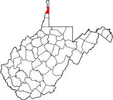
Location of Brooke County in West Virginia
This is a list of the National Register of Historic Places listings in Brooke County, West Virginia.
This is intended to be a complete list of the properties and districts on the National Register of Historic Places in Brooke County, West Virginia, United States. The locations of National Register properties and districts for which the latitude and longitude coordinates are included below, may be seen in a Google map.[1]
There are 23 properties and districts listed on the National Register in the county, 2 of which are National Historic Landmarks.
- This National Park Service list is complete through NPS recent listings posted December 2, 2016.[2]
Current listings
| [3] |
Name on the Register[4] |
Image |
Date listed[5] |
Location |
City or town |
Description |
|---|
| 1 |
Beallmore |
|
000000001986-05-16-0000May 16, 1986
(#86001069) |
1500 Pleasant Ave.
40°16′42″N 80°36′24″W / 40.278333°N 80.606667°W / 40.278333; -80.606667 (Beallmore) |
Wellsburg |
|
| 2 |
Bethany Historic District |
|
000000001982-04-01-0000April 1, 1982
(#82004311) |
West Virginia Route 67
40°12′22″N 80°33′16″W / 40.206111°N 80.554444°W / 40.206111; -80.554444 (Bethany Historic District) |
Bethany |
|
| 3 |
Brooke Cemetery |
|
000000001986-05-16-0000May 16, 1986
(#86001070) |
2200 Pleasant Ave.
40°17′15″N 80°36′17″W / 40.2875°N 80.604722°W / 40.2875; -80.604722 (Brooke Cemetery) |
Wellsburg |
|
| 4 |
Danforth Brown House |
|
000000001992-10-29-0000October 29, 1992
(#92001484) |
555 Washington Pike (West Virginia Route 27)
40°16′06″N 80°35′26″W / 40.268333°N 80.590556°W / 40.268333; -80.590556 (Danforth Brown House) |
Wellsburg |
|
| 5 |
Alexander Campbell Mansion |
|
000000001970-10-15-0000October 15, 1970
(#70000651) |
East of Bethany on West Virginia Route 67
40°12′27″N 80°32′51″W / 40.2075°N 80.5475°W / 40.2075; -80.5475 (Alexander Campbell Mansion) |
Bethany |
|
| 6 |
Delta Tau Delta Founders House |
|
000000001979-05-29-0000May 29, 1979
(#79002571) |
211 Main St.
40°12′19″N 80°33′27″W / 40.205278°N 80.5575°W / 40.205278; -80.5575 (Delta Tau Delta Founders House) |
Bethany |
|
| 7 |
Gen. I.H. Duval Mansion |
|
000000001986-05-16-0000May 16, 1986
(#86001071) |
1222 Pleasant Ave.
40°16′27″N 80°36′27″W / 40.274167°N 80.6075°W / 40.274167; -80.6075 (Gen. I.H. Duval Mansion) |
Wellsburg |
|
| 8 |
Elmhurst |
|
000000001986-05-16-0000May 16, 1986
(#86001072) |
1606 Pleasant Ave.
40°16′47″N 80°36′22″W / 40.279722°N 80.606111°W / 40.279722; -80.606111 (Elmhurst) |
Wellsburg |
|
| 9 |
David and Lucy Tarr Fleming Mansion |
|
000000001986-05-16-0000May 16, 1986
(#86001073) |
2000 Pleasant Ave.
40°16′55″N 80°36′20″W / 40.281944°N 80.605556°W / 40.281944; -80.605556 (David and Lucy Tarr Fleming Mansion) |
Wellsburg |
|
| 10 |
Lewis Hall Mansion |
|
000000001986-05-16-0000May 16, 1986
(#86001074) |
1300 Pleasant Ave.
40°16′31″N 80°36′27″W / 40.275278°N 80.6075°W / 40.275278; -80.6075 (Lewis Hall Mansion) |
Wellsburg |
|
| 11 |
Inn at Fowlerstown |
|
000000001992-10-29-0000October 29, 1992
(#92001483) |
1001 Washington Pike (West Virginia Route 27)
40°16′47″N 80°33′18″W / 40.279722°N 80.555°W / 40.279722; -80.555 (Inn at Fowlerstown) |
Wellsburg |
|
| 12 |
Kirker House |
|
000000001986-09-15-0000September 15, 1986
(#86002883) |
1520 Grand Ave.
40°16′43″N 80°36′20″W / 40.278611°N 80.605556°W / 40.278611; -80.605556 (Kirker House) |
Wellsburg |
|
| 13 |
Miller's Tavern |
|
000000001978-12-14-0000December 14, 1978
(#78002790) |
6th and Main Sts.
40°16′09″N 80°36′50″W / 40.269167°N 80.613889°W / 40.269167; -80.613889 (Miller's Tavern) |
Wellsburg |
|
| 14 |
Nicholls House and Woolen Mill Site |
|
000000001997-11-13-0000November 13, 1997
(#97001416) |
West Virginia Route 67, Wellsburg-Bethany Pike, overlooking Buffalo Creek
40°15′27″N 80°36′03″W / 40.2575°N 80.600833°W / 40.2575; -80.600833 (Nicholls House and Woolen Mill Site) |
Wellsburg |
|
| 15 |
Old Bethany Church |
|
000000001976-12-12-0000December 12, 1976
(#76001932) |
Main and Church Sts.
40°12′23″N 80°33′15″W / 40.206389°N 80.554167°W / 40.206389; -80.554167 (Old Bethany Church) |
Bethany |
|
| 16 |
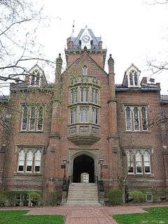
Old Main, Bethany College |
|
000000001970-08-25-0000August 25, 1970
(#70000652) |
Bethany College campus
40°12′21″N 80°33′37″W / 40.205833°N 80.560278°W / 40.205833; -80.560278 (Old Main, Bethany College) |
Bethany |
|
| 17 |
Harry and Louisiana Beall Paull Mansion |
|
000000001986-05-16-0000May 16, 1986
(#86001075) |
1312 Pleasant Ave.
40°16′29″N 80°36′23″W / 40.274722°N 80.606389°W / 40.274722; -80.606389 (Harry and Louisiana Beall Paull Mansion) |
Wellsburg |
|
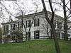
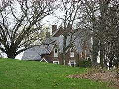
| 18 |
Pendleton Heights |
|
000000001975-06-26-0000June 26, 1975
(#75001882) |
Bethany College campus
40°12′24″N 80°33′35″W / 40.206667°N 80.559722°W / 40.206667; -80.559722 (Pendleton Heights) |
Bethany |
|
| 19 |
John C. Reeves House |
|
000000002006-09-28-0000September 28, 2006
(#06000903) |
100 Reeves Dr.
40°17′36″N 80°33′51″W / 40.293333°N 80.564167°W / 40.293333; -80.564167 (John C. Reeves House) |
Wellsburg |
|
| 20 |
Lucy Tarr Mansion |
|
000000001986-05-16-0000May 16, 1986
(#86001076) |
1456 Pleasant Ave.
40°16′40″N 80°36′24″W / 40.277778°N 80.606667°W / 40.277778; -80.606667 (Lucy Tarr Mansion) |
Wellsburg |
|
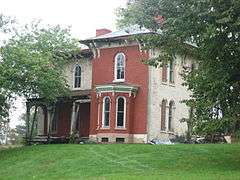
| 21 |
Vancroft |
|
000000001986-09-15-0000September 15, 1986
(#86002885) |
Brinker Rd.
40°17′07″N 80°35′51″W / 40.285278°N 80.5975°W / 40.285278; -80.5975 (Vancroft) |
Wellsburg |
|
| 22 |
Wellsburg Historic District |
|
000000001982-04-01-0000April 1, 1982
(#82004312) |
West Virginia Route 2
40°16′43″N 80°36′42″W / 40.278611°N 80.611667°W / 40.278611; -80.611667 (Wellsburg Historic District) |
Wellsburg |
|
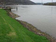
| 23 |
Wellsburg Wharf |
|
000000001979-11-27-0000November 27, 1979
(#79002572) |
6th and Main Sts.
40°16′09″N 80°36′52″W / 40.269167°N 80.614444°W / 40.269167; -80.614444 (Wellsburg Wharf) |
Wellsburg |
|
See also
References
- ↑ The latitude and longitude information provided in this table was derived originally from the National Register Information System, which has been found to be fairly accurate for about 99% of listings. For about 1% of NRIS original coordinates, experience has shown that one or both coordinates are typos or otherwise extremely far off; some corrections may have been made. A more subtle problem causes many locations to be off by up to 150 yards, depending on location in the country: most NRIS coordinates were derived from tracing out latitude and longitudes off of USGS topographical quadrant maps created under the North American Datum of 1927, which differs from the current, highly accurate WGS84 GPS system used by most on-line maps. Chicago is about right, but NRIS longitudes in Washington are higher by about 4.5 seconds, and are lower by about 2.0 seconds in Maine. Latitudes differ by about 1.0 second in Florida. Some locations in this table may have been corrected to current GPS standards.
- ↑ "National Register of Historic Places: Weekly List Actions". National Park Service, United States Department of the Interior. Retrieved on December 2, 2016.
- ↑ Numbers represent an ordering by significant words. Various colorings, defined here, differentiate National Historic Landmarks and historic districts from other NRHP buildings, structures, sites or objects.
- ↑ National Park Service (2008-04-24). "National Register Information System". National Register of Historic Places. National Park Service.
- ↑ The eight-digit number below each date is the number assigned to each location in the National Register Information System database, which can be viewed by clicking the number.
|
|---|
|
| Topics | | |
|---|
|
Lists by
county | |
|---|
|
| Other lists | |
|---|
|
-
 Category:National Register of Historic Places in West Virginia Category:National Register of Historic Places in West Virginia
-
 Portal:National Register of Historic Places Portal:National Register of Historic Places
|