National Register of Historic Places listings in Pocahontas County, West Virginia
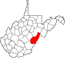
Location of Pocahontas County in West Virginia
This is a list of the National Register of Historic Places listings in Pocahontas County, West Virginia.
This is intended to be a complete list of the properties and districts on the National Register of Historic Places in Pocahontas County, West Virginia, United States. The locations of National Register properties and districts for which the latitude and longitude coordinates are included below, may be seen in a Google map.[1]
There are 21 properties and districts listed on the National Register in the county, 1 of which is a National Historic Landmark.
- This National Park Service list is complete through NPS recent listings posted December 2, 2016.[2]
Current listings
| [3] |
Name on the Register[4] |
Image |
Date listed[5] |
Location |
City or town |
Description |
|---|
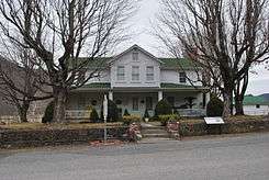
| 1 |
Richard Beard House |
Upload image |
000000002002-03-20-0000March 20, 2002
(#02000255) |
Off County Road 31 on Kyle Beard Rd.
38°05′16″N 80°14′15″W / 38.087778°N 80.2375°W / 38.087778; -80.2375 (Richard Beard House) |
Hillsboro |
|
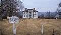
| 2 |
Pearl Buck House |
|
000000001970-06-15-0000June 15, 1970
(#70000663) |
Northeast of Hillsboro on U.S. Route 219
38°08′30″N 80°12′19″W / 38.141667°N 80.205278°W / 38.141667; -80.205278 (Pearl Buck House) |
Hillsboro |
|
| 3 |
Camp Allegheny |
|
000000001990-09-28-0000September 28, 1990
(#90001446) |
County Route 3, just east of County Route 5 at Top of Allegheny[6]
38°28′26″N 79°43′28″W / 38.473889°N 79.724444°W / 38.473889; -79.724444 (Camp Allegheny) |
Bartow |
|
| 4 |
Camp Bartow Historic District |
|
000000001996-05-10-0000May 10, 1996
(#95001325) |
Junction of U.S. Route 250 and West Virginia Routes 28 and 92
38°32′03″N 79°46′04″W / 38.534167°N 79.767778°W / 38.534167; -79.767778 (Camp Bartow Historic District) |
Bartow |
|
| 5 |
Cass Historic District |
|
000000001980-11-28-0000November 28, 1980
(#80004038) |
WV 66 and County Route 1
38°23′29″N 79°55′08″W / 38.391389°N 79.918889°W / 38.391389; -79.918889 (Cass Historic District) |
Cass |
|
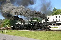
| 6 |
Cass Scenic Railroad |
|
000000001974-07-12-0000July 12, 1974
(#74002019) |
Along railroad tracks from Cass to Bald Knob
38°25′58″N 79°56′14″W / 38.432778°N 79.937222°W / 38.432778; -79.937222 (Cass Scenic Railroad) |
Cass |
|
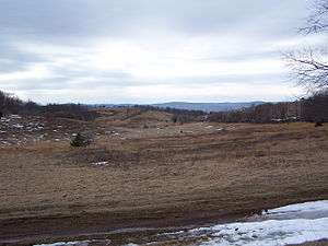
| 7 |
Droop Mountain Battlefield |
|
000000001970-01-26-0000January 26, 1970
(#70000664) |
About 14 miles south of Marlinton on U.S. Route 219
38°06′36″N 80°16′20″W / 38.11°N 80.272222°W / 38.11; -80.272222 (Droop Mountain Battlefield) |
Marlinton |
|
| 8 |
GW Jeep Site |
Upload image |
000000001993-12-23-0000December 23, 1993
(#93001443) |
Address Restricted
|
Greenbank |
Extends into Highland County, Virginia
|
| 9 |
Frank and Anna Hunter House |
Upload image |
000000001976-05-13-0000May 13, 1976
(#76001945) |
U.S. Route 219
38°13′14″N 80°06′03″W / 38.220556°N 80.100833°W / 38.220556; -80.100833 (Frank and Anna Hunter House) |
Marlinton |
|
| 10 |
Huntersville Presbyterian Church |
Upload image |
000000001978-10-04-0000October 4, 1978
(#78002809) |
County Route 21 at WV 39
38°11′23″N 80°01′06″W / 38.189722°N 80.018333°W / 38.189722; -80.018333 (Huntersville Presbyterian Church) |
Huntersville |
|
| 11 |
IOOF Lodge Building |
Upload image |
000000002000-03-24-0000March 24, 2000
(#00000249) |
Junction of 8th St. and Second Ave.
38°13′25″N 80°05′40″W / 38.223528°N 80.094444°W / 38.223528; -80.094444 (IOOF Lodge Building) |
Marlinton |
|
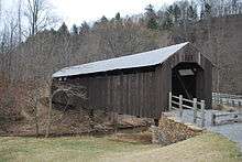
| 12 |
Locust Creek Covered Bridge |
|
000000001981-06-04-0000June 4, 1981
(#81000607) |
County Route 31 at County Route 20
38°04′46″N 80°15′01″W / 38.079444°N 80.250278°W / 38.079444; -80.250278 (Locust Creek Covered Bridge) |
Hillsboro |
|
| 13 |
Marlinton Chesapeake and Ohio Railroad Station |
|
000000001979-08-29-0000August 29, 1979
(#79002598) |
8th St. and 4th Ave.
38°13′21″N 80°05′34″W / 38.2225°N 80.092778°W / 38.2225; -80.092778 (Marlinton Chesapeake and Ohio Railroad Station) |
Marlinton |
Destroyed by fire[7]
|
| 14 |
Marlinton Opera House |
|
000000002000-03-24-0000March 24, 2000
(#00000253) |
Third Ave.
38°13′21″N 80°05′41″W / 38.2225°N 80.094722°W / 38.2225; -80.094722 (Marlinton Opera House) |
Marlinton |
|
| 15 |
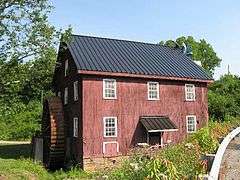
McNeel Mill |
|
000000001985-08-08-0000August 8, 1985
(#85001783) |
U.S. Route 219
38°09′26″N 80°10′55″W / 38.157222°N 80.181944°W / 38.157222; -80.181944 (McNeel Mill) |
Mill Point |
|
| 16 |
New Deal Resources in Watoga State Park Historic District |
Upload image |
000000002011-02-04-0000February 4, 2011
(#10001227) |
HC 82 (9 miles southwest of WV 39)
38°07′01″N 80°07′41″W / 38.116944°N 80.128056°W / 38.116944; -80.128056 (New Deal Resources in Watoga State Park Historic District) |
Marlinton vicinity |
|
| 17 |
Pleasant Green Methodist Episcopal Church |
Upload image |
000000002012-12-12-0000December 12, 2012
(#12001052) |
Seebert Rd.
38°08′30″N 80°11′23″W / 38.141805°N 80.189854°W / 38.141805; -80.189854 (Pleasant Green Methodist Episcopal Church) |
Seebert |
|
| 18 |
Pocahontas County Courthouse and Jail |
Upload image |
000000001994-07-15-0000July 15, 1994
(#94000724) |
900C Tenth Ave.
38°13′04″N 80°05′18″W / 38.217778°N 80.088333°W / 38.217778; -80.088333 (Pocahontas County Courthouse and Jail) |
Marlinton |
|
| 19 |
Pocahontas Times Print Shop |
Upload image |
000000001977-09-22-0000September 22, 1977
(#77001379) |
810 2nd Ave.
38°13′23″N 80°05′42″W / 38.223056°N 80.095°W / 38.223056; -80.095 (Pocahontas Times Print Shop) |
Marlinton |
|
| 20 |
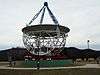
Reber Radio Telescope |
|
000000001972-11-09-0000November 9, 1972
(#72001291) |
National Radio Astronomy Observatory, northeast of Green Bank on WV 28/WV 92
38°25′49″N 79°49′04″W / 38.430278°N 79.817778°W / 38.430278; -79.817778 (Reber Radio Telescope) |
Green Bank |
|
| 21 |
Seebert Lane Colored School |
Upload image |
000000002012-12-12-0000December 12, 2012
(#12001053) |
Seebert Rd.
38°08′47″N 80°11′39″W / 38.146332°N 80.194049°W / 38.146332; -80.194049 (Seebert Lane Colored School) |
Seebert |
|
See also
References
- ↑ The latitude and longitude information provided in this table was derived originally from the National Register Information System, which has been found to be fairly accurate for about 99% of listings. For about 1% of NRIS original coordinates, experience has shown that one or both coordinates are typos or otherwise extremely far off; some corrections may have been made. A more subtle problem causes many locations to be off by up to 150 yards, depending on location in the country: most NRIS coordinates were derived from tracing out latitude and longitudes off of USGS topographical quadrant maps created under the North American Datum of 1927, which differs from the current, highly accurate WGS84 GPS system used by most on-line maps. Chicago is about right, but NRIS longitudes in Washington are higher by about 4.5 seconds, and are lower by about 2.0 seconds in Maine. Latitudes differ by about 1.0 second in Florida. Some locations in this table may have been corrected to current GPS standards.
- ↑ "National Register of Historic Places: Weekly List Actions". National Park Service, United States Department of the Interior. Retrieved on December 2, 2016.
- ↑ Numbers represent an ordering by significant words. Various colorings, defined here, differentiate National Historic Landmarks and historic districts from other NRHP buildings, structures, sites or objects.
- ↑ National Park Service (2008-04-24). "National Register Information System". National Register of Historic Places. National Park Service.
- ↑ The eight-digit number below each date is the number assigned to each location in the National Register Information System database, which can be viewed by clicking the number.
- ↑ Monongahela National Forest (Map). 1:126,720. Monongahela National Forest. 2007. ISBN 978-1-59351-857-8.
- ↑ Grimes, Cathy; Stewart, Suzanne (2008-03-29). "Fire Destroys Marlinton Depot". The Inter-Mountain. Archived from the original on 2009-01-18. Retrieved 2009-01-18.
|
|---|
|
| Topics | | |
|---|
|
Lists by
county | |
|---|
|
| Other lists | |
|---|
|
-
 Category:National Register of Historic Places in West Virginia Category:National Register of Historic Places in West Virginia
-
 Portal:National Register of Historic Places Portal:National Register of Historic Places
|