| [3] |
Name on the Register[4] |
Image |
Date listed[5] |
Location |
City or town |
Description |
|---|
| 1 |
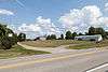
D.I.B. Anderson Farm |
|
000000001994-03-25-0000March 25, 1994
(#94000213) |
3333 Collins Ferry Rd.
39°39′36″N 79°58′27″W / 39.66°N 79.974167°W / 39.66; -79.974167 (D.I.B. Anderson Farm) |
Morgantown |
|
| 2 |
Brown Building |
|
000000001985-07-08-0000July 8, 1985
(#85001514) |
295 High St.
39°37′47″N 79°57′22″W / 39.629722°N 79.956111°W / 39.629722; -79.956111 (Brown Building) |
Morgantown |
|
| 3 |
Camp Rhododendron |
|
000000001991-05-15-0000May 15, 1991
(#91000545) |
Off Interstate 68 8 mi (13 km) east of Morgantown
39°38′18″N 79°48′56″W / 39.638333°N 79.815556°W / 39.638333; -79.815556 (Camp Rhododendron) |
Morgantown |
|
| 4 |
Chancery Hill Historic District |
|
000000001999-12-03-0000December 3, 1999
(#99001401) |
Roughly bounded by S. High St., Oak Grove Cemetery, Waitman, Allison, and Simpson Sts. and 256 Prairie Ave.
39°37′20″N 79°57′43″W / 39.622222°N 79.961944°W / 39.622222; -79.961944 (Chancery Hill Historic District) |
Morgantown |
The 2001 boundary increase added the Alexander Wade House to the district.
|
| 5 |
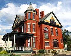
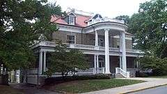
Judge Frank Cox House |
|
000000001984-01-12-0000January 12, 1984
(#84003626) |
206 Spruce St.
39°37′27″N 79°57′20″W / 39.624167°N 79.955556°W / 39.624167; -79.955556 (Judge Frank Cox House) |
Morgantown |
|
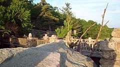
| 6 |
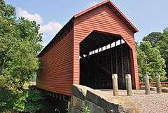
Dents Run Covered Bridge |
|
000000001981-06-04-0000June 4, 1981
(#81000604) |
County Route 43/4 near junction of County Route 43 crossing Dents Run
39°37′26″N 80°02′24″W / 39.623889°N 80.04°W / 39.623889; -80.04 (Dents Run Covered Bridge) |
Laurel Point |
|
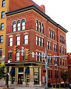
| 7 |
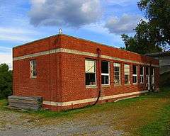
Dering Building |
|
000000001994-11-04-0000November 4, 1994
(#94001288) |
175-177 Walnut St.
39°37′49″N 79°57′25″W / 39.630278°N 79.956944°W / 39.630278; -79.956944 (Dering Building) |
Morgantown |
|
| 8 |
Downtown Morgantown Historic District |
|
000000001996-05-02-0000May 2, 1996
(#96000441) |
Roughly bounded by Chestnut and Spruce Sts. between Foundry and Willey Sts.
39°37′47″N 79°57′26″W / 39.629722°N 79.957222°W / 39.629722; -79.957222 (Downtown Morgantown Historic District) |
Morgantown |
|
| 9 |
Easton Roller Mill |
|
000000001978-12-19-0000December 19, 1978
(#78002806) |
Near Easton Hill on County Route 119/17
39°39′00″N 79°54′45″W / 39.65°N 79.9125°W / 39.65; -79.9125 (Easton Roller Mill) |
Morgantown |
|
| 10 |
Ford House |
|
000000001993-11-15-0000November 15, 1993
(#93001227) |
310 Ford St.
39°37′18″N 79°57′45″W / 39.621667°N 79.9625°W / 39.621667; -79.9625 (Ford House) |
Morgantown |
|
| 11 |
Fourth Ward School |
|
000000002004-08-25-0000August 25, 2004
(#04000914) |
287 Eureka Dr.
39°38′25″N 79°56′56″W / 39.640278°N 79.948889°W / 39.640278; -79.948889 (Fourth Ward School) |
Morgantown |
|
| 12 |
Greenmont Historic District |
|
000000002005-02-02-0000February 2, 2005
(#04001597) |
Roughly bounded by Arlington, Front, Conn, White Ave., Posten Ave., Kingwood St., and Decker Ave.
39°37′31″N 79°57′00″W / 39.625278°N 79.95°W / 39.625278; -79.95 (Greenmont Historic District) |
Morgantown |
|
| 13 |
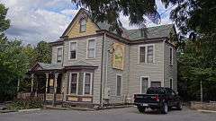
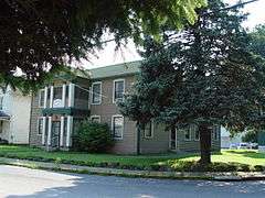
Hackney House |
|
000000001999-07-01-0000July 1, 1999
(#99000789) |
89 Kingwood St.
39°37′39″N 79°57′08″W / 39.6275°N 79.952222°W / 39.6275; -79.952222 (Hackney House) |
Morgantown |
|
| 14 |
Hamilton Farm Petroglyphs |
|
000000001974-08-07-0000August 7, 1974
(#74002015) |
Southeast of Ringgold on U.S. Route 119[6]
39°33′34″N 79°56′16″W / 39.5594°N 79.9378°W / 39.5594; -79.9378 (Hamilton Farm Petroglyphs) |
Ringgold |
|
| 15 |
Harmony Grove Meeting House |
|
000000001983-09-16-0000September 16, 1983
(#83003245) |
Off Interstate 79
39°36′12″N 79°59′25″W / 39.603333°N 79.990278°W / 39.603333; -79.990278 (Harmony Grove Meeting House) |
Harmony Grove |
|
| 16 |
Harner Homestead |
|
000000001984-01-12-0000January 12, 1984
(#84003629) |
1818 Listravia St.
39°37′26″N 79°55′14″W / 39.623889°N 79.920556°W / 39.623889; -79.920556 (Harner Homestead) |
Morgantown |
|
| 17 |
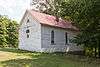
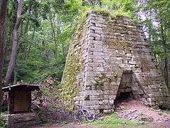
Henry Clay Furnace |
|
000000001970-01-26-0000January 26, 1970
(#70000658) |
Southeast of Cheat Neck in Coopers Rock State Forest
39°38′56″N 79°49′07″W / 39.648889°N 79.818611°W / 39.648889; -79.818611 (Henry Clay Furnace) |
Cheat Neck |
|
| 18 |
Kern's Fort |
|
000000001993-04-09-0000April 9, 1993
(#93000225) |
305 Dewey St.
39°37′31″N 79°56′59″W / 39.625278°N 79.949722°W / 39.625278; -79.949722 (Kern's Fort) |
Morgantown |
|
| 19 |
Kincaid and Arnett Feed and Flour Building |
|
000000001995-07-21-0000July 21, 1995
(#95000873) |
156 Clay St.
39°37′31″N 79°57′50″W / 39.625278°N 79.963889°W / 39.625278; -79.963889 (Kincaid and Arnett Feed and Flour Building) |
Morgantown |
|
| 20 |
Lynch Chapel United Methodist Church |
|
000000002006-11-15-0000November 15, 2006
(#06001046) |
Junction of County Routes 32 and 41
39°37′23″N 80°05′05″W / 39.623056°N 80.084722°W / 39.623056; -80.084722 (Lynch Chapel United Methodist Church) |
Morgantown |
|
| 21 |
Mason and Dixon Survey Terminal Point |
|
000000001973-06-25-0000June 25, 1973
(#73001922) |
2.25 mi (3.62 km) northeast of Pentress on County Route 39
39°43′16″N 80°07′07″W / 39.721111°N 80.118611°W / 39.721111; -80.118611 (Mason and Dixon Survey Terminal Point) |
Pentress |
Extends into Perry Township in Greene County, Pennsylvania
|
| 22 |
Men's Hall |
|
000000001990-02-05-0000February 5, 1990
(#89002309) |
Prospect and High Sts.
39°37′59″N 79°57′10″W / 39.633056°N 79.952778°W / 39.633056; -79.952778 (Men's Hall) |
Morgantown |
|
| 23 |
Metropolitan Theatre |
|
000000001984-01-12-0000January 12, 1984
(#84003631) |
371 S. High St.
39°37′51″N 79°57′20″W / 39.630833°N 79.955556°W / 39.630833; -79.955556 (Metropolitan Theatre) |
Morgantown |
|
| 24 |
Monongalia County Courthouse |
|
000000001985-07-08-0000July 8, 1985
(#85001525) |
243 High St.
39°37′47″N 79°57′26″W / 39.629722°N 79.957222°W / 39.629722; -79.957222 (Monongalia County Courthouse) |
Morgantown |
|
| 25 |
Elizabeth Moore Hall |
|
000000001985-12-19-0000December 19, 1985
(#85003208) |
University Ave.
39°38′06″N 79°57′20″W / 39.635°N 79.955556°W / 39.635; -79.955556 (Elizabeth Moore Hall) |
Morgantown |
|
| 26 |
Morgantown Wharf and Warehouse Historic District |
|
000000001998-12-16-0000December 16, 1998
(#98001466) |
Roughly along the Monongahela River from Warren St. to Walnut St.
39°37′42″N 79°57′39″W / 39.628333°N 79.960833°W / 39.628333; -79.960833 (Morgantown Wharf and Warehouse Historic District) |
Morgantown |
|
| 27 |
Oglebay Hall |
|
000000001985-12-19-0000December 19, 1985
(#85003207) |
University Ave.
39°38′14″N 79°57′16″W / 39.637222°N 79.954444°W / 39.637222; -79.954444 (Oglebay Hall) |
Morgantown |
|
| 28 |
Old Morgantown Post Office |
|
000000001979-03-28-0000March 28, 1979
(#79002593) |
107 High St.
39°37′41″N 79°57′29″W / 39.628056°N 79.958056°W / 39.628056; -79.958056 (Old Morgantown Post Office) |
Morgantown |
|
| 29 |
Old Stone House |
|
000000001972-12-27-0000December 27, 1972
(#72001290) |
Chestnut St.
39°37′49″N 79°57′26″W / 39.630278°N 79.957222°W / 39.630278; -79.957222 (Old Stone House) |
Morgantown |
|
| 30 |
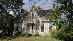
Old Watson Homestead House |
|
000000001984-12-07-0000December 7, 1984
(#84003871) |
County Route 73
39°31′46″N 80°02′38″W / 39.529444°N 80.043889°W / 39.529444; -80.043889 (Old Watson Homestead House) |
Smithtown |
|
| 31 |
Purinton House |
|
000000001985-12-19-0000December 19, 1985
(#85003206) |
University Ave.
39°38′05″N 79°57′20″W / 39.634722°N 79.955556°W / 39.634722; -79.955556 (Purinton House) |
Morgantown |
|
| 32 |
Rogers House |
|
000000001984-12-04-0000December 4, 1984
(#84000683) |
293 Willey St.
39°37′53″N 79°57′09″W / 39.631389°N 79.9525°W / 39.631389; -79.9525 (Rogers House) |
Morgantown |
|
| 33 |
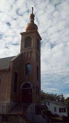
St. Mary's Orthodox Church |
|
000000001988-02-03-0000February 3, 1988
(#87002525) |
W. Park and Holland Aves.
39°38′03″N 79°57′43″W / 39.634167°N 79.961944°W / 39.634167; -79.961944 (St. Mary's Orthodox Church) |
Westover |
|
| 34 |
Second Ward Negro Elementary School |
|
000000001992-07-28-0000July 28, 1992
(#92000896) |
Junction of White and Posten Aves.
39°37′17″N 79°56′57″W / 39.621389°N 79.949167°W / 39.621389; -79.949167 (Second Ward Negro Elementary School) |
Morgantown |
|
| 35 |
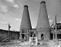
Seneca Glass Company Building |
|
000000001985-12-19-0000December 19, 1985
(#85003214) |
709 Beechurst Ave.
39°38′28″N 79°57′44″W / 39.641111°N 79.962222°W / 39.641111; -79.962222 (Seneca Glass Company Building) |
Morgantown |
|
| 36 |
South Park Historic District |
|
000000001990-07-23-0000July 23, 1990
(#90001054) |
Roughly bounded by Elgin St., Kingwood St., Cobun Ave., Prairie Ave., Jefferson St., Lincoln Ave., and Grand St.
39°37′21″N 79°57′08″W / 39.6225°N 79.952222°W / 39.6225; -79.952222 (South Park Historic District) |
Morgantown |
|
| 37 |
Stalnaker Hall |
|
000000001985-12-19-0000December 19, 1985
(#85003205) |
Maiden Ln.
39°38′08″N 79°57′11″W / 39.635556°N 79.953056°W / 39.635556; -79.953056 (Stalnaker Hall) |
Morgantown |
|
| 38 |
Stewart Hall |
|
000000001980-06-25-0000June 25, 1980
(#80004034) |
West Virginia University campus
39°38′03″N 79°57′16″W / 39.634167°N 79.954444°W / 39.634167; -79.954444 (Stewart Hall) |
Morgantown |
|
| 39 |
Vance Farmhouse |
|
000000001991-11-21-0000November 21, 1991
(#91001731) |
1535 Mileground, West Virginia University
39°38′23″N 79°56′13″W / 39.639722°N 79.936944°W / 39.639722; -79.936944 (Vance Farmhouse) |
Morgantown |
|
| 40 |
Alexander Wade House |
|
000000001966-10-15-0000October 15, 1966
(#66000752) |
256 Prairie St.
39°37′29″N 79°57′30″W / 39.624722°N 79.958333°W / 39.624722; -79.958333 (Alexander Wade House) |
Morgantown |
|
| 41 |
Walters House |
|
000000001983-08-18-0000August 18, 1983
(#83003246) |
221 Willey St.
39°37′55″N 79°57′13″W / 39.631944°N 79.953611°W / 39.631944; -79.953611 (Walters House) |
Morgantown |
|
| 42 |
Waitman T. Willey House |
|
000000001982-04-15-0000April 15, 1982
(#82004327) |
128 Wagner Rd.
39°37′30″N 79°57′34″W / 39.625°N 79.959444°W / 39.625; -79.959444 (Waitman T. Willey House) |
Morgantown |
|
| 43 |
Women's Christian Temperance Union Community Building |
|
000000001985-10-30-0000October 30, 1985
(#85003406) |
160 Fayette St.
39°37′52″N 79°57′22″W / 39.631111°N 79.956111°W / 39.631111; -79.956111 (Women's Christian Temperance Union Community Building) |
Morgantown |
|
| 44 |
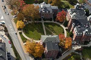
Woodburn Circle |
|
000000001974-12-04-0000December 4, 1974
(#74002014) |
University Ave., West Virginia University
39°38′09″N 79°57′35″W / 39.635833°N 79.959722°W / 39.635833; -79.959722 (Woodburn Circle) |
Morgantown |
|


_2.jpg)
.jpg)

_WVU_Morgantown_WV.jpg)

.jpg)

_Morgantown_WV.jpg)
_front.jpg)