| [3] |
Name on the Register |
Image |
Date listed[4] |
Location |
City or town |
Description |
|---|
| 1 |
Barton Hall |
|
000000001973-11-07-0000November 7, 1973
(#73000337) |
2.5 miles (4 km) west of Cherokee on U.S. Route 72
34°45′09″N 88°00′12″W / 34.7525°N 88.003333°W / 34.7525; -88.003333 (Barton Hall) |
Cherokee |
|
| 2 |
Belle Mont |
|
000000001982-02-23-0000February 23, 1982
(#82002003) |
Southeast of Tuscumbia
34°39′42″N 87°40′01″W / 34.661667°N 87.666944°W / 34.661667; -87.666944 (Belle Mont) |
Tuscumbia |
|
| 3 |
Buzzard Roost |
|
000000001976-11-07-0000November 7, 1976
(#76000157) |
3 miles west of Cherokee on U.S. Route 72
34°45′37″N 88°01′24″W / 34.760278°N 88.023333°W / 34.760278; -88.023333 (Buzzard Roost) |
Cherokee |
|
| 4 |
Clyde Carter House |
Upload image |
000000002004-06-02-0000June 2, 2004
(#04000559) |
300 Lime Kiln Rd.
34°47′27″N 87°31′36″W / 34.790833°N 87.526667°W / 34.790833; -87.526667 (Clyde Carter House) |
Ford City |
|
| 5 |
Chambers-Robinson House |
|
000000001993-05-14-0000May 14, 1993
(#93000419) |
910 Montgomery Ave.
34°46′04″N 87°41′53″W / 34.767639°N 87.698056°W / 34.767639; -87.698056 (Chambers-Robinson House) |
Sheffield |
|
| 6 |
John and Archibald Christian House |
|
000000001982-02-04-0000February 4, 1982
(#82002004) |
Off U.S. Route 72
34°43′05″N 87°42′14″W / 34.718056°N 87.703889°W / 34.718056; -87.703889 (John and Archibald Christian House) |
Tuscumbia |
|
| 7 |
Colbert County Courthouse Square Historic District |
|
000000001973-05-24-0000May 24, 1973
(#73000338) |
Roughly bounded by E. and W. 2nd, N. and S. Cave, E. and W. 6th, and N. and S. Indian Sts.
34°44′02″N 87°42′15″W / 34.733889°N 87.704167°W / 34.733889; -87.704167 (Colbert County Courthouse Square Historic District) |
Tuscumbia |
|
| 8 |
Ivy Green |
|
000000001970-08-25-0000August 25, 1970
(#70000101) |
300 W. North Common
34°44′21″N 87°42′23″W / 34.739167°N 87.706389°W / 34.739167; -87.706389 (Ivy Green) |
Tuscumbia |
|
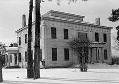
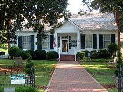
| 9 |
Johnson's Woods |
|
000000001988-05-04-0000May 4, 1988
(#88000511) |
801 E. North Commons
34°44′26″N 87°41′35″W / 34.740556°N 87.693056°W / 34.740556; -87.693056 (Johnson's Woods) |
Tuscumbia |
|
| 10 |
John Johnson House |
Upload image |
000000001986-07-09-0000July 9, 1986
(#86001537) |
Near the junction of Fosters Mill and River Rds.
34°46′04″N 87°27′15″W / 34.767778°N 87.454167°W / 34.767778; -87.454167 (John Johnson House) |
Leighton |
|
| 11 |
La Grange Rock Shelter |
Upload image |
000000001974-06-13-0000June 13, 1974
(#74000406) |
Address Restricted
|
Leighton |
|
| 12 |
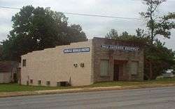
Muscle Shoals Sound Studio |
|
000000002006-06-02-0000June 2, 2006
(#06000437) |
3614 Jackson Highway
34°46′05″N 87°40′27″W / 34.767944°N 87.674167°W / 34.767944; -87.674167 (Muscle Shoals Sound Studio) |
Sheffield |
|
| 13 |
E.L. Newman Lustron House |
|
000000002000-02-24-0000February 24, 2000
(#00000134) |
1406 34th St.
34°46′14″N 87°40′49″W / 34.770556°N 87.680278°W / 34.770556; -87.680278 (E.L. Newman Lustron House) |
Sheffield |
|
| 14 |
Nitrate Village No. 1 Historic District |
Upload image |
000000001984-08-30-0000August 30, 1984
(#84000603) |
Roughly bounded by Wilson Dam Circle, Wheeler and Wilson Dam Aves., Fontana, and Pickwick Sts.
34°44′32″N 87°43′14″W / 34.742222°N 87.720556°W / 34.742222; -87.720556 (Nitrate Village No. 1 Historic District) |
Sheffield |
|
| 15 |
Felix Grundy Norman House |
|
000000001984-04-12-0000April 12, 1984
(#84000749) |
401 N. Main St.
34°44′08″N 87°42′14″W / 34.735556°N 87.703889°W / 34.735556; -87.703889 (Felix Grundy Norman House) |
Tuscumbia |
|
| 16 |
The Oaks |
|
000000001976-11-07-0000November 7, 1976
(#76000319) |
Southeast of Tuscumbia off State Route 157 on Ricks Lane
34°40′27″N 87°35′36″W / 34.674167°N 87.593333°W / 34.674167; -87.593333 (The Oaks) |
Tuscumbia |
|
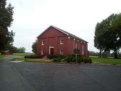
| 17 |
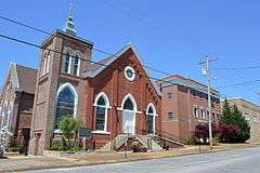
Old Brick Presbyterian Church |
|
000000001989-01-09-0000January 9, 1989
(#88003078) |
Old Brick Rd., north of Leighton
34°46′14″N 87°31′28″W / 34.770556°N 87.524444°W / 34.770556; -87.524444 (Old Brick Presbyterian Church) |
Leighton |
|
| 18 |
Preuit Oaks |
Upload image |
000000001986-05-08-0000May 8, 1986
(#86000997) |
Cotton Town Rd.
34°40′31″N 87°30′35″W / 34.675278°N 87.509722°W / 34.675278; -87.509722 (Preuit Oaks) |
Leighton |
|
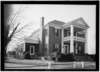
| 19 |
John Daniel Rather House |
|
000000001982-12-16-0000December 16, 1982
(#82001603) |
209 S. Cave St.
34°43′50″N 87°41′56″W / 34.730556°N 87.698889°W / 34.730556; -87.698889 (John Daniel Rather House) |
Tuscumbia |
|
| 20 |
Rock Creek Archeological District (ACt44,ACt45) |
Upload image |
000000001990-06-26-0000June 26, 1990
(#88003068) |
Address Restricted
|
Maud |
|
| 21 |
Seven Mile Island Archeological District |
Upload image |
000000001979-04-16-0000April 16, 1979
(#79003352) |
Address Restricted
|
Sheffield |
|
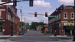
| 22 |
Sheffield Downtown Commercial Historic District |
|
000000002010-05-24-0000May 24, 2010
(#10000271) |
1st and 5th Sts. and Pittsburgh and Columbia Aves.
34°45′39″N 87°41′59″W / 34.760875°N 87.699719°W / 34.760875; -87.699719 (Sheffield Downtown Commercial Historic District) |
Sheffield |
|
| 23 |
Sheffield Residential Historic District |
|
000000002002-05-16-0000May 16, 2002
(#02000481) |
Roughly bounded by Riverside Pike, River Bluff Dr., Wood, 3rd, and 2nd Sts., 15th Ave., 27th St., and 19th Ave.
34°45′56″N 87°41′51″W / 34.765556°N 87.697500°W / 34.765556; -87.697500 (Sheffield Residential Historic District) |
Sheffield |
|
| 24 |
Tuscumbia Historic District |
|
000000001985-05-23-0000May 23, 1985
(#85001158) |
Roughly bounded by N. and E. Commons, 8th St. and Spring Rd., Hooks, W. 5th and S. Milton, including Steel Bridge
34°43′59″N 87°42′07″W / 34.733056°N 87.701944°W / 34.733056; -87.701944 (Tuscumbia Historic District) |
Tuscumbia |
|
| 25 |
Tuscumbia Landing Site |
Upload image |
000000001982-06-10-0000June 10, 1982
(#82002002) |
West of Sheffield
34°44′56″N 87°43′31″W / 34.748889°N 87.725278°W / 34.748889; -87.725278 (Tuscumbia Landing Site) |
Sheffield |
|
| 26 |
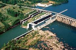
Wilson Dam |
|
000000001966-11-13-0000November 13, 1966
(#66000147) |
On the Tennessee River along State Route 133
34°48′04″N 87°37′38″W / 34.801111°N 87.627222°W / 34.801111; -87.627222 (Wilson Dam) |
Florence |
Extends into Lauderdale County
|
| 27 |
William Winston House |
|
000000001982-04-15-0000April 15, 1982
(#82002005) |
N. Commons St.
34°44′18″N 87°42′04″W / 34.738333°N 87.701111°W / 34.738333; -87.701111 (William Winston House) |
Tuscumbia |
|


_AND_EAST_SIDE_-_G._W._Carroll_House%2C_801_East_North_Commons%2C_Tuscumbia%2C_Colbert_County%2C_AL_HABS_ALA%2C17-TUSM%2C8-2.tif.jpg)


.jpg)
.jpg)

.jpg)