National Register of Historic Places listings in St. Clair County, Alabama
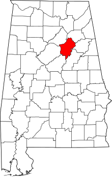
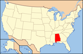
Location of St. Clair County in Alabama
This is a list of the National Register of Historic Places listings in St. Clair County, Alabama.
This is intended to be a complete list of the properties and districts on the National Register of Historic Places in St. Clair County, Alabama, United States. Latitude and longitude coordinates are provided for many National Register properties and districts; these locations may be seen together in a Google map.[1]
There are 15 properties and districts listed on the National Register in the county.
- This National Park Service list is complete through NPS recent listings posted December 16, 2016.[2]
Current listings
| [3] | Name on the Register | Image | Date listed[4] | Location | City or town | Description |
|---|---|---|---|---|---|---|
| 1 | John Ash House | Upload image | (#91001479) |
U.S. Route 411 west of its junction with U.S. Route 231 33°46′16″N 86°18′08″W / 33.771111°N 86.302222°W |
Ashville | |
| 2 | Ashville Historic District |  |
(#05000288) |
Bounded by State Route 23, Greensport Rd., 8th Ave., Waldrop Dr., State Route 231, and 5th St. 33°50′08″N 86°15′12″W / 33.835556°N 86.253333°W |
Ashville | |
| 3 | Avondale Mill Historic District | 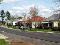 |
(#00001030) |
Roughly bounded by 25th St., N., 7th Ave., N., 30th St., N., and south of 4th Ave., N. 33°35′33″N 86°16′42″W / 33.5925°N 86.278333°W |
Pell City | |
| 4 | Dr. James J. Bothwell House | 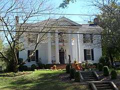 |
(#82004612) |
Hartford Ave. 33°50′06″N 86°15′16″W / 33.835°N 86.254444°W |
Ashville | |
| 5 | Fort Strother Site | Upload image | (#72001440) |
Off Lock 3 Road along the Coosa River 33°45′49″N 86°02′51″W / 33.763611°N 86.0475°W |
Ohatchee vicinity | |
| 6 | Jacob Green House | Upload image | (#80004238) |
East of Ashville on State Route 33 33°53′09″N 86°07′03″W / 33.885833°N 86.1175°W |
Ashville | |
| 7 | Inzer House | 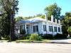 |
(#73002127) |
Hartford Ave. 33°50′08″N 86°15′19″W / 33.835556°N 86.255278°W |
Ashville | |
| 8 | Looney House | 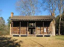 |
(#74002179) |
5 miles west of Ashville on Greenport Rd. 33°49′12″N 86°11′44″W / 33.82°N 86.195556°W |
Ashville | |
| 9 | Rev. Thomas Newton House | Upload image | (#91001480) |
South of U.S. Route 411, west of its junction with U.S. Route 231 33°45′15″N 86°18′51″W / 33.754167°N 86.314167°W |
Ashville | |
| 10 | Old Pell City Historic District | 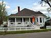 |
(#01001291) |
Roughly bounded by 16th St., N., 1st Ave., N., 22nd St., N., and 4th Ave., N. 33°35′17″N 86°17′10″W / 33.587954°N 86.286192°W |
Pell City | |
| 11 | Pell City Downtown Historic District | 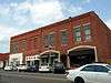 |
(#01001169) |
1900-2111 Cogwell Ave, 2008 1st Ave., S., 8 N. 21st St., and 10 S. 20th St. 33°35′11″N 86°17′04″W / 33.586389°N 86.284444°W |
Pell City | |
| 12 | Presley Store | 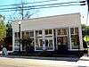 |
(#83002982) |
601 Main St. 33°46′29″N 86°28′17″W / 33.774722°N 86.471389°W |
Springville | |
| 13 | Judge Elisha Robinson House | 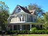 |
(#91000595) |
U.S. Route 231 south of its junction with State Route 23 33°50′05″N 86°15′19″W / 33.834628°N 86.255164°W |
Ashville | |
| 14 | St. Clair Springs | Upload image | (#76002140) |
State Route 23 33°45′51″N 86°24′17″W / 33.764167°N 86.404722°W |
St. Clair Springs | |
| 15 | Springville Historic District | 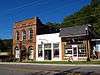 |
(#97000653) |
Roughly bounded by Academy, Wilson, and Cross Sts., the Norfolk Southern railroad tracks, Industrial Dr., and Sarusce St. 33°46′33″N 86°28′14″W / 33.775833°N 86.470556°W |
Springville |
See also
| Wikimedia Commons has media related to National Register of Historic Places in St. Clair County, Alabama. |
- List of National Historic Landmarks in Alabama
- National Register of Historic Places listings in Alabama
References
- ↑ The latitude and longitude information provided in this table was derived originally from the National Register Information System, which has been found to be fairly accurate for about 99% of listings. For about 1% of NRIS original coordinates, experience has shown that one or both coordinates are typos or otherwise extremely far off; some corrections may have been made. A more subtle problem causes many locations to be off by up to 150 yards, depending on location in the country: most NRIS coordinates were derived from tracing out latitude and longitudes off of USGS topographical quadrant maps created under the North American Datum of 1927, which differs from the current, highly accurate WGS84 GPS system used by most on-line maps. Chicago is about right, but NRIS longitudes in Washington are higher by about 4.5 seconds, and are lower by about 2.0 seconds in Maine. Latitudes differ by about 1.0 second in Florida. Some locations in this table may have been corrected to current GPS standards.
- ↑ "National Register of Historic Places: Weekly List Actions". National Park Service, United States Department of the Interior. Retrieved on December 16, 2016.
- ↑ Numbers represent an ordering by significant words. Various colorings, defined here, differentiate National Historic Landmarks and historic districts from other NRHP buildings, structures, sites or objects.
- ↑ The eight-digit number below each date is the number assigned to each location in the National Register Information System database, which can be viewed by clicking the number.

Municipalities and communities of St. Clair County, Alabama, United States | ||
|---|---|---|
| Cities | | |
| Towns | ||
| Unincorporated communities | ||
| Former towns | ||
| Footnotes | ‡This populated place also has portions in an adjacent county or counties | |
This article is issued from Wikipedia - version of the 1/16/2016. The text is available under the Creative Commons Attribution/Share Alike but additional terms may apply for the media files.