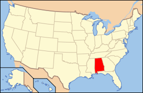
| [3] |
Name on the Register |
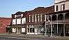
Image |
Date listed[4] |
Location |
City or town |
Description |
|---|
| 1 |
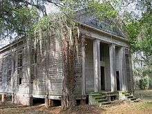
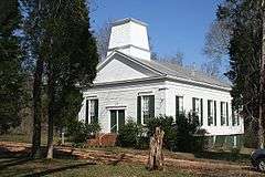
Adams Grove Presbyterian Church |
|
000000001986-06-05-0000June 5, 1986
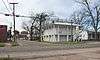
(#86001239) |
Southern side of Cahaba-Greenville Rd.
32°16′20″N 87°01′51″W / 32.272222°N 87.030833°W / 32.272222; -87.030833 (Adams Grove Presbyterian Church) |
Sardis |
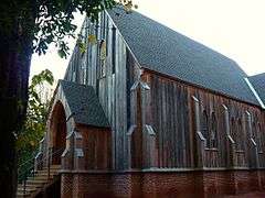
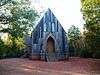
Wooden-framed Presbyterian church, built in the Greek Revival style in 1853.
|
| 2 |
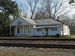
Antique Store |
|
000000001987-01-29-0000January 29, 1987
(#86003662) |
Off State Route 22
32°39′32″N 86°55′24″W / 32.659023°N 86.923292°W / 32.659023; -86.923292 (Antique Store) |
Plantersville |
|
| 3 |
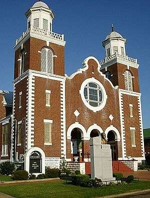
Brown Chapel African Methodist Episcopal Church |
|
000000001982-02-04-0000February 4, 1982
(#82002009) |
410 Martin Luther King, Jr. St.
32°24′45″N 87°00′58″W / 32.4125°N 87.016111°W / 32.4125; -87.016111 (Brown Chapel African Methodist Episcopal Church) |
Selma |
Brick African Methodist Episcopal church, built in 1908. Known for its association with the Civil Rights Movement and Selma to Montgomery marches.
|
| 4 |
Cahaba |
|
000000001973-05-08-0000May 8, 1973
(#73000341) |
11 miles (18 km) southwest of Selma at the junction of the Cahaba and Alabama Rivers
32°19′07″N 87°05′57″W / 32.318546°N 87.099266°W / 32.318546; -87.099266 (Cahaba) |
Cahaba |
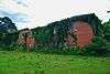
First permanent state capital of Alabama (1820–1825); today a ghost town.
|
| 5 |
Carlowville Historic District |
|
000000001978-01-18-0000January 18, 1978
(#78000487) |
17 miles (27 km) south of Selma on State Route 89
32°05′15″N 87°02′01″W / 32.087392°N 87.033691°W / 32.087392; -87.033691 (Carlowville Historic District) |
Carlowville |
|
| 6 |
Christian Church and Parsonage |
|
000000001987-01-29-0000January 29, 1987
(#86003664) |
Off State Route 22
32°39′24″N 86°55′29″W / 32.656667°N 86.924722°W / 32.656667; -86.924722 (Christian Church and Parsonage) |
Plantersville |
|
| 7 |
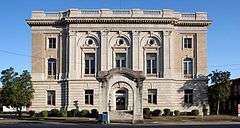
Dallas County Courthouse |
|
000000001975-06-20-0000June 20, 1975
(#75000310) |
109 Union St.
32°24′18″N 87°01′33″W / 32.405°N 87.025833°W / 32.405; -87.025833 (Dallas County Courthouse) |
Selma |
Three-story brick building in the Greek Revival style, built as the Central Masonic Institute in 1847. It later served as the county courthouse and as a hospital.
|
| 8 |
Doctor's Office |
Upload image |
000000001987-01-29-0000January 29, 1987
(#86003663) |
Junction of 1st Ave. north of Oak St. and 1st Ave.
32°41′03″N 86°55′24″W / 32.684167°N 86.923333°W / 32.684167; -86.923333 (Doctor's Office) |
Plantersville |
|
| 9 |
Driskell-Martin House |
|
000000001987-01-29-0000January 29, 1987
(#86003661) |
Northwestern corner of the junction of Cherry St. and 1st Ave.
32°39′36″N 86°55′26″W / 32.66°N 86.923889°W / 32.66; -86.923889 (Driskell-Martin House) |
Plantersville |
|
| 10 |
First Baptist Church |
|
000000001979-09-20-0000September 20, 1979
(#79000383) |
709 Martin Luther King, Jr. St.
32°24′51″N 87°01′04″W / 32.414167°N 87.017778°W / 32.414167; -87.017778 (First Baptist Church) |
Selma |
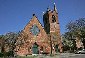
Historically African American Baptist church, built in the Gothic Revival style in 1894. Known for its association with the Civil Rights Movement.
|
| 11 |
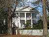
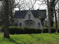
J. Bruce Hain House |
|
000000002001-11-30-0000November 30, 2001
(#01001295) |
5826 State Route 41
32°17′17″N 86°59′14″W / 32.288056°N 86.987222°W / 32.288056; -86.987222 (J. Bruce Hain House) |
Sardis |
|
| 12 |
Icehouse Historic District |
|
000000001990-06-28-0000June 28, 1990
(#90000886) |
Roughly bounded by Jefferson Davis and Dallas Aves., Union and Lapsley Sts., and Valley Creek
32°24′39″N 87°01′54″W / 32.410889°N 87.031653°W / 32.410889; -87.031653 (Icehouse Historic District) |
Selma |
|
| 13 |
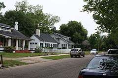
Sullivan and Richie Jean Jackson House |
Upload image |
000000002014-01-18-0000January 18, 2014
(#13001033) |
1416 Lapsley Ave.
32°25′09″N 87°01′52″W / 32.419070°N 87.031244°W / 32.419070; -87.031244 (Sullivan and Richie Jean Jackson House) |
Selma |
|
| 14 |
Marshall's Grove |
|
000000001982-02-04-0000February 4, 1982
(#82002010) |
State Route 22
32°27′58″N 87°00′23″W / 32.466111°N 87.006389°W / 32.466111; -87.006389 (Marshall's Grove) |
Selma |
|
| 15 |
John Tyler Morgan House |
|
000000001972-09-27-0000September 27, 1972
(#72000159) |
719 Tremont St.
32°24′49″N 87°01′39″W / 32.413611°N 87.0275°W / 32.413611; -87.0275 (John Tyler Morgan House) |
Selma |
|
| 16 |
Old Town Historic District |
|
000000001978-05-03-0000May 3, 1978
(#78000486) |
Roughly bounded by the Alabama River, Jefferson Davis Ave., Pettus, Broad, and Franklin Sts.; also Jefferson Davis Ave.; an area roughly bounded by Broad, Dallas, U.S. Route 80, and Franklin; Selma Ave.; and Franklin St.
32°24′37″N 87°01′31″W / 32.410201°N 87.025323°W / 32.410201; -87.025323 (Old Town Historic District) |
Selma |
Boundaries after the "also" represent a boundary increase of 000000002003-12-15-0000December 15, 2003
|
| 17 |
Edmund Pettus Bridge |
|
000000002013-02-27-0000February 27, 2013
(#13000281) |
U.S. Route 80 across the Alabama River
32°24′20″N 87°01′07″W / 32.4056°N 87.0186°W / 32.4056; -87.0186 (Edmund Pettus Bridge) |
Selma |
|
| 18 |
Wesley Plattenburg House |
|
000000001993-02-03-0000February 3, 1993
(#92001827) |
601 Washington St.
32°24′50″N 87°01′20″W / 32.413889°N 87.022222°W / 32.413889; -87.022222 (Wesley Plattenburg House) |
Selma |
|
| 19 |
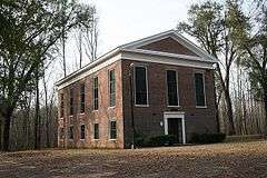
Pleasant Hill Presbyterian Church |
|
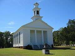
000000001999-04-22-0000April 22, 1999
(#99000465) |
0.2 miles (0.32 km) east of the junction of County Roads 7 and 12
32°09′53″N 86°54′30″W / 32.164722°N 86.908333°W / 32.164722; -86.908333 (Pleasant Hill Presbyterian Church) |
Pleasant Hill |
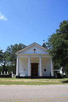
Wooden-framed Presbyterian church, built in the Greek Revival style in 1851.
|
| 20 |
Riverdale |
|
000000001979-09-10-0000September 10, 1979
(#79000384) |
Northeast of Selma on River Rd.
32°26′02″N 86°52′11″W / 32.433889°N 86.869722°W / 32.433889; -86.869722 (Riverdale) |
Selma |
|
| 21 |
Riverview Historic District |
|
000000001990-06-28-0000June 28, 1990
(#90000887) |
Roughly bounded by Selma Ave., Satterfield and Lapsley Sts., and the Alabama River
32°24′11″N 87°01′50″W / 32.403063°N 87.030666°W / 32.403063; -87.030666 (Riverview Historic District) |
Selma |
|
| 22 |
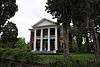
St. Luke's Episcopal Church |
|
000000001982-03-25-0000March 25, 1982
(#82002008) |
Beech St. (Cahaba Rd.) near intersection with Capitol Ave.
32°19′09″N 87°06′19″W / 32.319167°N 87.105278°W / 32.319167; -87.105278 (St. Luke's Episcopal Church) |
Cahaba |
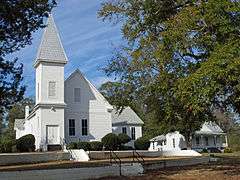
Wooden-framed Episcopal church, built in the Carpenter Gothic style in 1854.
|
| 23 |
St. Paul's Episcopal Church |
|
000000001975-03-25-0000March 25, 1975
(#75000311) |
210 Lauderdale St.
32°24′31″N 87°01′18″W / 32.408611°N 87.021667°W / 32.408611; -87.021667 (St. Paul's Episcopal Church) |
Selma |
Brick Episcopal church, built in the Gothic Revival style in 1875.
|
| 24 |
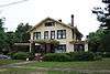
Marcus Meyer Skinner House |
|
000000001987-08-27-0000August 27, 1987
(#87001418) |
2612 Summerfield Rd.
32°26′15″N 87°02′01″W / 32.437431°N 87.033540°W / 32.437431; -87.033540 (Marcus Meyer Skinner House) |
Selma |
|
| 25 |
Street Manual Training School |
|
000000001999-07-28-0000July 28, 1999
(#99000891) |
263 County Road 38
32°06′49″N 87°03′34″W / 32.113657°N 87.059557°W / 32.113657; -87.059557 (Street Manual Training School) |
Richmond and Minter |
|
| 26 |
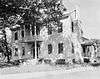
Sturdivant Hall |
|
000000001973-01-18-0000January 18, 1973
(#73000340) |
713 Mabry St.
32°24′47″N 87°01′44″W / 32.413056°N 87.028889°W / 32.413056; -87.028889 (Sturdivant Hall) |
Selma |
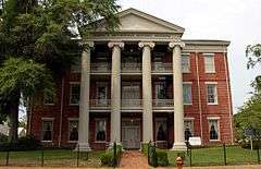
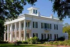
Greek Revival style mansion designed by Thomas Helm Lee and completed in 1856.
|
| 27 |
Summerfield District |
|
000000001982-03-01-0000March 1, 1982
(#82002011) |
Selma-Summerfield and Marion Rds., Centenary and College Sts.
32°31′03″N 87°02′45″W / 32.517434°N 87.045751°W / 32.517434; -87.045751 (Summerfield District) |
Summerfield |
|
| 28 |
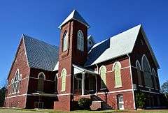
Tabernacle Baptist Church |
Upload image |
000000002013-07-10-0000July 10, 2013
(#13000469) |
1431 Broad St.
32°25′10″N 87°01′28″W / 32.419575°N 87.024486°W / 32.419575; -87.024486 (Tabernacle Baptist Church) |
Selma |
Part of the Civil Rights Movement in Selma, Alabama MPS
|
| 29 |
Todd House |
|
000000001987-01-29-0000January 29, 1987
(#86003665) |
Southern side of Oak St. west of 1st Ave.
32°39′21″N 86°55′52″W / 32.655833°N 86.931111°W / 32.655833; -86.931111 (Todd House) |
Plantersville |
|
| 30 |
U.S. Post Office Building |
|
000000001976-03-26-0000March 26, 1976
(#76000322) |
908 Alabama Ave.
32°24′27″N 87°01′15″W / 32.4075°N 87.020833°W / 32.4075; -87.020833 (U.S. Post Office Building) |
Selma |
Beaux-Arts style Federal Government building designed by James Knox Taylor and completed in 1909.
|
| 31 |
Valley Creek Presbyterian Church |
|
000000001976-05-28-0000May 28, 1976
(#76000323) |
North of Selma on Valley Creek Rd.
32°28′14″N 87°01′28″W / 32.470556°N 87.024444°W / 32.470556; -87.024444 (Valley Creek Presbyterian Church) |
Valley Grande |
Brick Presbyterian church, built in the Greek Revival style in 1857.
|
| 32 |
Water Avenue Historic District |
|
000000001972-12-26-0000December 26, 1972
(#72000160) |
Water Ave.; also Water Ave. bounded by Lauderdale, MLK Boulevard, Beech Creek, and the Alabama River
32°24′27″N 87°01′00″W / 32.40752°N 87.016783°W / 32.40752; -87.016783 (Water Avenue Historic District) |
Selma |
Second set of boundaries represents a boundary increase of 000000002005-07-07-0000July 7, 2005 |