| [2] |
Name on the Register |
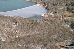
Image |
Date listed[3] |
Location |
City or town |
Description |
|---|
| 1 |
Beachbend |
Upload image |
000000001993-08-09-0000August 9, 1993
(#93000698) |
Smith Lane
40°54′10″N 73°11′03″W / 40.902778°N 73.184167°W / 40.902778; -73.184167 (Beachbend) |
Nissequogue |
|
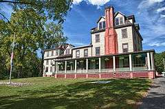
| 2 |
Blydenburgh Park Historic District |
|
000000001983-08-11-0000August 11, 1983
(#83001807) |
Blydenburgh County Park
40°50′36″N 73°13′34″W / 40.843333°N 73.226111°W / 40.843333; -73.226111 (Blydenburgh Park Historic District) |
Smithtown |
|
| 3 |
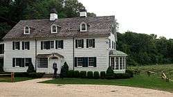
Box Hill Estate |
Upload image |
000000001973-12-04-0000December 4, 1973
(#73001276) |
Northwest of St. James on Moriches Road
40°53′22″N 73°10′36″W / 40.889444°N 73.176667°W / 40.889444; -73.176667 (Box Hill Estate) |
St. James |
|
| 4 |
By-the-Harbor |
Upload image |
000000001993-08-09-0000August 9, 1993
(#93000699) |
Moriches Road
40°53′30″N 73°10′51″W / 40.891667°N 73.180833°W / 40.891667; -73.180833 (By-the-Harbor) |
Nissequogue |
|
| 5 |
East Farm |
|
000000001993-08-09-0000August 9, 1993
(#93000700) |
Harbor Road, North side, at Shep Jones Lane
40°54′48″N 73°09′17″W / 40.913333°N 73.154722°W / 40.913333; -73.154722 (East Farm) |
Head of the Harbor |
|
| 6 |
First Presbyterian Church |
|
000000001977-12-23-0000December 23, 1977
(#77000983) |
175 East Main Street
40°51′24″N 73°11′18″W / 40.856667°N 73.188333°W / 40.856667; -73.188333 (First Presbyterian Church) |
Branch |
|
| 7 |
Fort Salonga |
Upload image |
000000001982-05-21-0000May 21, 1982
(#82003406) |
Address Restricted
|
Fort Salonga |
|
| 8 |
Halliock Inn |
|
000000001974-08-07-0000August 7, 1974
(#74001310) |
263 East Main Street
40°51′20″N 73°10′50″W / 40.855556°N 73.180556°W / 40.855556; -73.180556 (Halliock Inn) |
Branch |
|
| 9 |
Harbor House |
Upload image |
000000001993-08-09-0000August 9, 1993
(#93000701) |
Spring Hollow Road
40°53′48″N 73°10′44″W / 40.896667°N 73.178889°W / 40.896667; -73.178889 (Harbor House) |
Nissequogue |
|
| 10 |
Land of Clover |
Upload image |
000000001993-08-09-0000August 9, 1993
(#93000702) |
Long Beach Road, South side
40°54′48″N 73°11′12″W / 40.913333°N 73.186667°W / 40.913333; -73.186667 (Land of Clover) |
Nissequogue |
|
| 11 |
The Mallows |
Upload image |
000000001993-08-09-0000August 9, 1993
(#93000703) |
Emmet Way
40°54′59″N 73°09′07″W / 40.916389°N 73.151944°W / 40.916389; -73.151944 (The Mallows) |
Head of the Harbor |
|
| 12 |
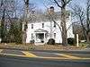
Mills Pond District |
|
000000001973-08-01-0000August 1, 1973
(#73001277) |
East of St. James on NY 25A
40°54′02″N 73°08′58″W / 40.900556°N 73.149444°W / 40.900556; -73.149444 (Mills Pond District) |
St. James |
|
| 13 |
James W. and Anne Smith Phyfe Estate |
Upload image |
000000001993-08-09-0000August 9, 1993
(#93000704) |
87 Stillwater Road
40°54′34″N 73°11′04″W / 40.909444°N 73.184444°W / 40.909444; -73.184444 (James W. and Anne Smith Phyfe Estate) |
Nissequogue |
|
| 14 |
Rassapeague |
Upload image |
000000001993-08-09-0000August 9, 1993
(#93000705) |
Long Beach Road, South side
40°54′58″N 73°10′55″W / 40.916111°N 73.181944°W / 40.916111; -73.181944 (Rassapeague) |
Nissequogue |
|
| 15 |
William J. Ryan Estate |
Upload image |
000000001993-08-09-0000August 9, 1993
(#93000706) |
Moriches Road
40°54′07″N 73°11′20″W / 40.901944°N 73.188889°W / 40.901944; -73.188889 (William J. Ryan Estate) |
Nissequogue |
|
| 16 |
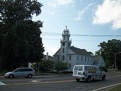
Saint James District |
|
000000001973-07-20-0000July 20, 1973
(#73001275) |
On NY 25A
40°53′02″N 73°09′46″W / 40.883889°N 73.162778°W / 40.883889; -73.162778 (Saint James District) |
Saint James |
|
| 17 |
Shore Cottage |
Upload image |
000000001993-08-09-0000August 9, 1993
(#93000707) |
Harbor Road, East side
40°53′39″N 73°10′23″W / 40.894167°N 73.173056°W / 40.894167; -73.173056 (Shore Cottage) |
Head of the Harbor |
|
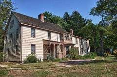
| 18 |
Obadiah Smith House |
|
000000001996-12-06-0000December 6, 1996
(#96001422) |
853 Saint Johnland Road
40°53′38″N 73°13′47″W / 40.893889°N 73.229722°W / 40.893889; -73.229722 (Obadiah Smith House) |
Kings Park |
|
| 19 |
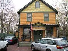
Village of Branch Historic District |
Upload image |
000000001986-09-11-0000September 11, 1986
(#86002514) |
Along north side of Middle Country Road
40°51′56″N 73°10′59″W / 40.865556°N 73.183056°W / 40.865556; -73.183056 (Village of Branch Historic District) |
Branch |
|
| 20 |
Kate Annette Wetherill Estate |
|
000000001993-08-09-0000August 9, 1993
(#93000708) |
Harbor Hill Road, South side
40°53′32″N 73°10′11″W / 40.892222°N 73.169722°W / 40.892222; -73.169722 (Kate Annette Wetherill Estate) |
Head of the Harbor |
|
| 21 |
Woodcrest |
Upload image |
000000001993-08-09-0000August 9, 1993
(#93000709) |
Moriches Road
40°54′00″N 73°10′59″W / 40.9°N 73.183056°W / 40.9; -73.183056 (Woodcrest) |
Nissequogue |
|
| 22 |
Wyandanch Club Historic District |
|
000000001990-08-03-0000August 3, 1990
(#90001143) |
Jericho Turnpike, southwest of its junction with Meadow Road
40°51′03″N 73°13′40″W / 40.850833°N 73.227778°W / 40.850833; -73.227778 (Wyandanch Club Historic District) |
Smithtown |
|
%2C_Saint_James%2C_Suffolk_County%2C_NY_HABS_NY%2C52-STJAM.V%2C1-6.tif.jpg)
.jpg)