National Register of Historic Places listings in Poughkeepsie, New York

Location of Poughkeepsie in New York
List of the National Register of Historic Places listings in Poughkeepsie, New York
This is intended to be a complete list of properties and districts listed on the National Register of Historic Places in the city and town of Poughkeepsie, New York, including the hamlet of New Hamburg. The locations of National Register properties and districts (at least for all showing latitude and longitude coordinates below) may be seen in a Google map by clicking on "Map of all coordinates".[1]
- This National Park Service list is complete through NPS recent listings posted December 2, 2016.[2]
| Albany (Albany) – Allegany – Bronx – Broome – Cattaraugus – Cayuga – Chautauqua – Chemung – Chenango – Clinton – Columbia – Cortland – Delaware – Dutchess (Poughkeepsie, Rhinebeck) – Erie (Buffalo) – Essex – Franklin – Fulton – Genesee – Greene – Hamilton – Herkimer – Jefferson – Kings – Lewis – Livingston – Madison – Monroe (Rochester) – Montgomery – Nassau – New York (Below 14th Street, 14th to 59th Streets, 59th to 110th Streets, Above 110th Street, Islands) – Niagara – Oneida – Onondaga (Syracuse) – Ontario – Orange – Orleans – Oswego – Otsego – Putnam – Queens – Rensselaer – Richmond – Rockland – St. Lawrence – Saratoga – Schenectady – Schoharie – Schuyler – Seneca – Steuben – Suffolk – Sullivan – Tioga – Tompkins – Ulster – Warren – Washington – Wayne – Westchester (Northern, Southern, New Rochelle, Peekskill, Yonkers) – Wyoming – Yates |
Current listings
| [3] | Name on the Register | Image | Date listed[4] | Location | City or town | Description |
|---|---|---|---|---|---|---|
| 1 | Academy Street Historic District | 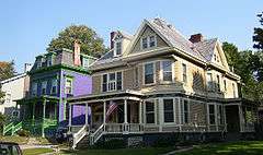 |
(#82001117) |
Academy St. between Livingston and Montgomery Sts. 41°41′44″N 73°55′44″W / 41.695556°N 73.928889°W |
Poughkeepsie | First planned neighborhood in city; many Victorian-era homes. |
| 2 | Adriance Memorial Library |  |
(#82001118) |
93 Market St. 41°42′01″N 73°55′52″W / 41.700278°N 73.931111°W |
Poughkeepsie | City's first library building in 1897 |
| 3 | Amrita Club | 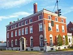 |
(#82001119) |
170 Church St. 41°42′06″N 73°55′48″W / 41.701667°N 73.93°W |
Poughkeepsie | Home of city's most prestigious club, built in 1922, is one of only two brick Colonial Revival non-residential buildings in city |
| 4 | F.R. Bain House | Upload image | (#15001023) |
57 Montgomery St. Coordinates missing |
Poughkeepsie | Intact Queen Anne house built for local developer in 1888 |
| 5 | Balding Avenue Historic District | 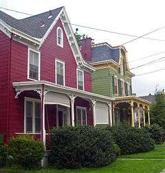 |
(#82001120) |
Balding Ave. between Mansion and Marshall Sts. 41°42′29″N 73°55′37″W / 41.708056°N 73.926944°W |
Poughkeepsie | Late 19th century middle-class neighborhood just north of downtown |
| 6 | Barrett House | 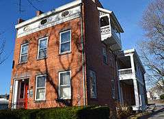 |
(#82001122) |
55 Noxon St. 41°42′02″N 73°55′41″W / 41.700556°N 73.928056°W |
Poughkeepsie | 1835 Greek Revival home which belonged to local artist, Thomas Barrett. Now a local arts center bearing his name. |
| 7 | O. H. Booth Hose Company | 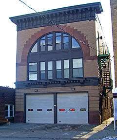 |
(#82001123) |
532 Main St. 41°42′04″N 73°55′04″W / 41.701111°N 73.917778°W |
Poughkeepsie | Second-story arched window is unusual in 1908 firehouse |
| 8 | Boughton/Haight House | 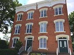 |
(#82001124) |
73-75 S. Hamilton St. 41°41′53″N 73°55′34″W / 41.698056°N 73.926111°W |
Poughkeepsie | |
| 9 | Abraham Brower House | 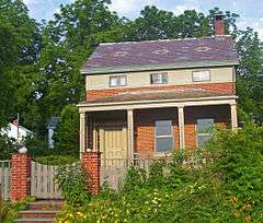 |
(#87000116) |
2 Water St. 41°35′21″N 73°57′00″W / 41.589167°N 73.95°W |
New Hamburg | Intact vernacular Greek Revival mid-19th century home of early resident |
| 10 | Adolph Brower House | 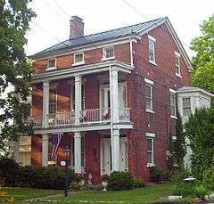 |
(#87000114) |
1 Water St. 41°35′22″N 73°57′01″W / 41.589444°N 73.950278°W |
New Hamburg | Intact vernacular Greek Revival mid-19th century home of early lime quarry owner |
| 11 | Building at 73 Mansion St. | 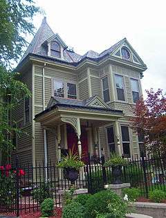 |
(#97000531) |
73 Mansion St. 41°42′25″N 73°55′39″W / 41.706944°N 73.9275°W |
Poughkeepsie | 1890 Queen Anne built by local real estate attorney |
| 12 | Cedarcliff Gatehouse | 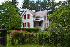 |
(#82001125) |
66 Ferris Lane 41°41′03″N 73°55′13″W / 41.684167°N 73.920278°W |
Poughkeepsie | Historic gatehouse built about 1845 |
| 13 | Church of the Holy Comforter |  |
(#72000831) |
13 Davies St. 41°42′22″N 73°56′13″W / 41.706111°N 73.936944°W |
Poughkeepsie | Richard Upjohn-designed church; landmark of city to traffic on US 9 |
| 14 | Church Street Row |  |
(#82001126) |
Church St. from Academy to Hamilton St. 41°42′02″N 73°55′34″W / 41.700556°N 73.926111°W |
Poughkeepsie | Largest group of 19th-century brick residences in city |
| 15 | Clark House | Upload image | (#82001127) |
85 Cedar Ave. 41°40′26″N 73°54′19″W / 41.673889°N 73.905278°W |
Poughkeepsie | |
| 16 | CLEARWATER (Sloop) |  |
(#04000376) |
Main St. on the Hudson River 41°42′26″N 73°56′28″W / 41.707222°N 73.941111°W |
Poughkeepsie | Dutch-style sloop started pioneering environmental organization in 1970s |
| 17 | Clinton House |  |
(#82001128) |
547 Main St. 41°42′01″N 73°54′58″W / 41.700192°N 73.916206°W |
Poughkeepsie | 1765 stone house mistakenly believed to have been home at one time to George Clinton; now home to Dutchess County Historical Society |
| 18 | Collingwood Opera House and Office Building | 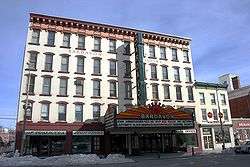 |
(#77000939) |
31-37 Market St. 41°42′11″N 73°55′45″W / 41.703056°N 73.929167°W |
Poughkeepsie | Now Bardavon Theatre. Built in 1869 and still a popular venue for bands, movies, and comedians. |
| 19 | Corlies–Hart–Ritter House | 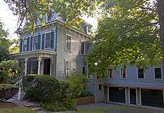 |
(#14000486) |
103 S. Hamilton St. 41°41′42″N 73°55′42″W / 41.695045°N 73.9282747°W |
Poughkeepsie | 1872 Second Empire house that was home to three successive families important in local musical history |
| 20 | Dixon House | Upload image | (#82001129) |
49 N. Clinton St. 41°42′18″N 73°55′12″W / 41.705°N 73.92°W |
Poughkeepsie | |
| 21 | Dutchess County Court House | 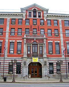 |
(#82001130) |
10 Market St. 41°42′14″N 73°55′47″W / 41.703889°N 73.929722°W |
Poughkeepsie | 1903 courthouse is third building on site of original 1721 courthouse |
| 22 | Dwight-Hooker Avenue Historic District |  |
(#82001132) |
Dwight St. from Hamilton to Hooker, and 79-85 Hooker Ave. 41°41′39″N 73°55′26″W / 41.694167°N 73.923889°W |
Poughkeepsie | |
| 23 | Eastman Terrace |  |
(#82001133) |
1-10 Eastman Terr. 41°41′48″N 73°55′54″W / 41.696667°N 73.931667°W |
Poughkeepsie | Historic rowhouse block built in 1872 |
| 24 | Ethol House |  |
(#82001134) |
171 Hooker Ave. 41°41′18″N 73°54′59″W / 41.688333°N 73.916389°W |
Poughkeepsie | Built about 1910 and is a 1 1⁄2-story, three-bay-wide frame Bungalow–style dwelling. |
| 25 | Farmer's and Manufacturer's Bank | 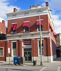 |
(#82001135) |
43 Market St. 41°42′10″N 73°55′46″W / 41.702778°N 73.929444°W |
Poughkeepsie | Only remaining non-residential Greek Revival building in city |
| 26 | First Baptist Church | 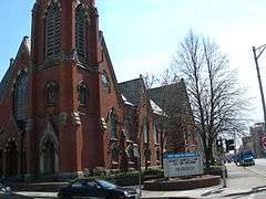 |
(#01000774) |
260 Mill St. 41°42′19″N 73°55′43″W / 41.705278°N 73.928611°W |
Poughkeepsie | |
| 27 | First Presbyterian Church | 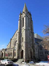 |
(#82001136) |
25 S. Hamilton St. 41°42′04″N 73°55′29″W / 41.701111°N 73.924722°W |
Poughkeepsie | |
| 28 | First Presbyterian Church Rectory |  |
(#82001137) |
98 Cannon St. 41°42′04″N 73°55′31″W / 41.701111°N 73.925278°W |
Poughkeepsie | |
| 29 | Freer House | 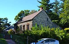 |
(#82001138) |
70 Wilbur Boulevard 41°40′46″N 73°54′38″W / 41.679444°N 73.910556°W |
Poughkeepsie | Farmers cottage built about 1728 and is the oldest extant structure in the City of Poughkeepsie |
| 30 | Garfield Place Historic District | 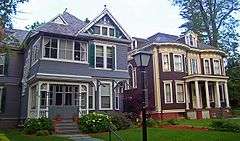 |
(#72000832) |
Both sides of Garfield Pl. 41°41′52″N 73°55′49″W / 41.697778°N 73.930278°W |
Poughkeepsie | Mid-19th century neighborhood homes for those who became wealthy from early industrialization. Renamed in memory of James A. Garfield after his assassination. |
| 31 | Glebe House | 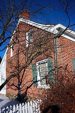 |
(#82001139) |
635 Main St. 41°41′54″N 73°54′44″W / 41.698333°N 73.912222°W |
Poughkeepsie | 1767 home for local minister |
| 32 | Gregory House | 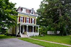 |
(#82001140) |
140 S. Cherry St. 41°41′45″N 73°55′05″W / 41.695833°N 73.918056°W |
Poughkeepsie | Built in 1869, is an historic Second Empire style building. |
| 33 | Grey Hook | 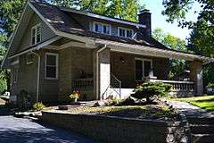 |
(#82001141) |
5 Ferris Lane 41°41′18″N 73°55′03″W / 41.688333°N 73.9175°W |
Poughkeepsie | Built in 1911 and is a 1 1⁄2-story, two-bay-wide concrete block Bungalow-style dwelling. |
| 34 | Harlow Row | 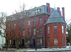 |
(#82001142) |
100-106 Market St. 41°42′00″N 73°55′53″W / 41.7°N 73.931389°W |
Poughkeepsie | Built by former mayor William Harlow as affordable townhouses in 1874 |
| 35 | Hasbrouck House | 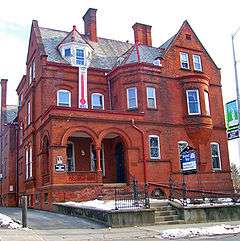 |
(#82001143) |
75-77 Market St. 41°42′05″N 73°55′48″W / 41.701389°N 73.93°W |
Poughkeepsie | Unusually large Romanesque Revival house for a city Poughkeepsie's size; today headquarters of county United Way |
| 36 | Hershkind House | 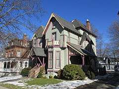 |
(#82001144) |
30 Hooker Ave. 41°41′51″N 73°55′26″W / 41.6975°N 73.923889°W |
Poughkeepsie | |
| 37 | Hoffman House | Upload image | (#07000669) |
N. Water St. Coordinates missing |
Poughkeepsie | |
| 38 | Hudson River State Hospital, Main Building | 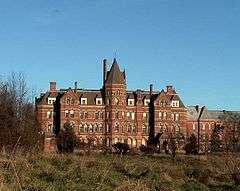 |
(#89001166) |
Off U.S. Route 9 41°43′57″N 73°55′44″W / 41.7325°N 73.928889°W |
Town of Poughkeepsie | Frederick Clarke Withers-designed High Victorian Gothic building was part of a new way to treat mental illness |
| 39 | Italian Center |  |
(#72000833) |
225-227 Mill St. 41°42′23″N 73°55′47″W / 41.706389°N 73.929722°W |
Poughkeepsie | 1860s townhouse for wealthy family on west edge of downtown |
| 40 | Kimlin Cider Mill |  |
(#03000020) |
Cedar Ave. 41°40′02″N 73°54′17″W / 41.667222°N 73.904722°W |
Poughkeepsie | Mid-19th Century barn converted to a cider mill that became a popular local attraction for much of the 20th Century |
| 41 | Lady Washington Hose Company | 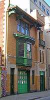 |
(#82001145) |
20 Academy St. 41°42′08″N 73°55′35″W / 41.702222°N 73.926389°W |
Poughkeepsie | Unusual combination of Gothic Revival and Japanese-inspired architecture |
| 42 | Locust Grove | 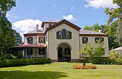 |
(#66000515) |
370 South St. 41°40′27″N 73°56′07″W / 41.674167°N 73.935278°W |
Town of Poughkeepsie | Alexander Jackson Davis-designed Italian villa-style estate of Samuel F.B. Morse; preserved as it was by later owners |
| 43 | Luckey, Platt & Company Department Store | 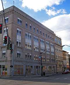 |
(#82001146) |
332-346 Main Mall 41°42′10″N 73°55′35″W / 41.702778°N 73.926389°W |
Poughkeepsie | Early department store was at one point the only one in Hudson Valley between Yonkers and Albany; major draw to city's downtown. |
| 44 | Mader House | 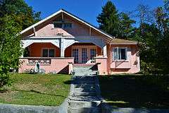 |
(#82001147) |
101 Corlies Ave. 41°42′14″N 73°54′27″W / 41.703889°N 73.9075°W |
Poughkeepsie | Built about 1925 and is a 1 1⁄2-story, bungalow-style dwelling sheathed in pink stucco |
| 45 | Main Building, Vassar College | 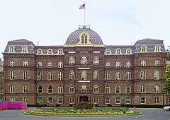 |
(#73001183) |
Vassar College campus 41°41′12″N 73°53′45″W / 41.686667°N 73.895833°W |
Town of Poughkeepsie | 1861 Second Empire building was beginning of pioneering American women's college |
| 46 | Main Mall Row | 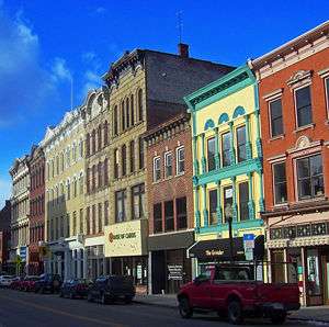 |
(#82001148) |
315 Main Mall to 11 Garden St. 41°42′13″N 73°55′38″W / 41.703611°N 73.927222°W |
Poughkeepsie | Well-preserved stretch of 19th-century commercial buildings; was centerpiece of former Main Mall |
| 47 | Main Street Historic District |  |
(#87000122) |
Main St. roughly bounded by Stone and Bridge Sts. 41°35′15″N 73°56′56″W / 41.5875°N 73.948889°W |
New Hamburg | Small core of hamlet with intact mid-19th century houses |
| 48 | Maple Grove |  |
(#01000293) |
301 S. Rd., U.S. Route 9 41°40′52″N 73°55′39″W / 41.681111°N 73.9275°W |
Poughkeepsie | Historic estate circa 1850 |
| 49 | Market Street Row | 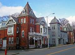 |
(#82001149) |
88-94 Market St. 41°42′05″N 73°55′51″W / 41.701389°N 73.930833°W |
Poughkeepsie | Group of three houses across from Adriance Library and Hasbrouck House includes oldest frame house in city. |
| 50 | Peter and Karen McComb House | Upload image | (#08000098) |
27 Hornbeck Ridge 41°40′02″N 73°53′15″W / 41.667242°N 73.887481°W |
Poughkeepsie | |
| 51 | Mill Street-North Clover Street Historic District | 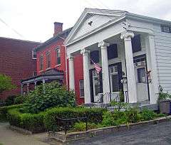 |
(#72000834) |
Mill, Mansion, Vassar, and N. Clover Sts., Davies and Lafayette Pl.; also 101-115 Main and 25, 27, 29, and 32 N. Bridge Sts. 41°42′24″N 73°56′01″W / 41.706667°N 73.933611°W |
Poughkeepsie | Mid-19th century neighborhood not demolished during urban renewal; second set of boundaries represents a boundary increase of May 21, 1987 |
| 52 | Moore House | 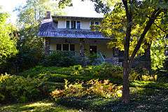 |
(#82001150) |
37 Adriance Ave. 41°41′27″N 73°55′28″W / 41.690833°N 73.924444°W |
Poughkeepsie | 1½-story, bungalow-style dwelling with slate roof built about 1910 |
| 53 | Charles Morschauser House | 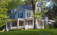 |
(#14000487) |
115 Hooker Ave. 41°41′25″N 73°55′19″W / 41.6903982°N 73.9220537°W |
Poughkeepsie | 1902 Queen Anne home of prominent local lawyer |
| 54 | Mulrien House | 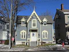 |
(#82001153) |
64 Montgomery St. 41°41′59″N 73°55′34″W / 41.699722°N 73.926111°W |
Poughkeepsie | |
| 55 | New York State Armory | 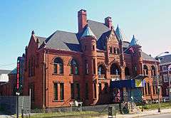 |
(#82001154) |
61-65 Market St. 41°42′07″N 73°55′47″W / 41.701944°N 73.929722°W |
Poughkeepsie | Isaac G. Perry-designed Romanesque Revival building |
| 56 | Niagara Engine House | 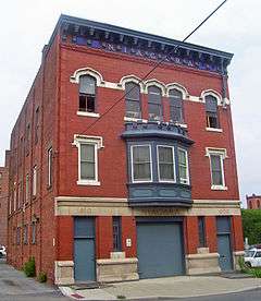 |
(#82001155) |
8 N. Hamilton St. 41°42′09″N 73°55′26″W / 41.7025°N 73.923889°W |
Poughkeepsie | 1909 Late Gothic Revival firehouse by local architect Percival M. Lloyd. Only one of the city's six engine company firehouses remaining. |
| 57 | Pelton Mill | 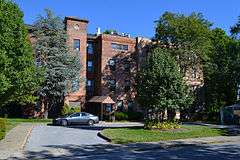 |
(#82001156) |
110 Mill St. 41°42′30″N 73°56′11″W / 41.708333°N 73.936389°W |
Poughkeepsie | Historic carpet mill now re-purposed as apartments |
| 58 | Phillips House | 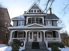 |
(#82001157) |
18 Barclay St. 41°41′51″N 73°55′37″W / 41.6975°N 73.926944°W |
Poughkeepsie | |
| 59 | Post-Williams House | 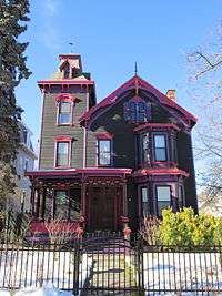 |
(#82001158) |
44 S. Clinton St. 41°41′53″N 73°55′23″W / 41.698056°N 73.923056°W |
Poughkeepsie | |
| 60 | Poughkeepsie Almshouse and City Infirmary | Upload image | (#78001849) |
20 Maple St. 41°42′02″N 73°54′45″W / 41.700556°N 73.9125°W |
Poughkeepsie | |
| 61 | Poughkeepsie City Hall | 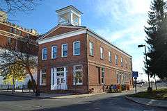 |
(#72000835) |
228 Main St. 41°42′14″N 73°55′48″W / 41.703889°N 73.93°W |
Poughkeepsie | Former city hall constructed in 1831 in the Greek Revival Style. Now used as the Commissioner of Jurors Office. |
| 62 | Poughkeepsie Meeting House (Hooker Avenue) | 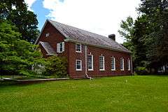 |
(#89000306) |
249 Hooker Ave. 41°41′10″N 73°54′42″W / 41.6861°N 73.9118°W |
Poughkeepsie | Historic Quaker (Society of Friends) meeting house built in 1927. |
| 63 | Poughkeepsie Meeting House (Montgomery Street) | 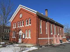 |
(#89000304) |
112 Montgomery St. 41°41′57″N 73°55′35″W / 41.699167°N 73.926389°W |
Poughkeepsie | |
| 64 | Poughkeepsie Railroad Bridge | 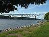 |
(#79001577) |
Spans the Hudson River 41°42′38″N 73°57′15″W / 41.710556°N 73.954167°W |
Poughkeepsie | 1889 trestle bridge built by New Haven Railroad; abandoned in 1974, the bridge was opened in October, 2009 as Walkway Over The Hudson, a New York State Park. Extends into Highland in Ulster County |
| 65 | Poughkeepsie Railroad Station |  |
(#76001214) |
Main St. 41°42′26″N 73°56′18″W / 41.707222°N 73.938333°W |
Poughkeepsie | 1918 station is small-scale model of Grand Central Terminal building |
| 66 | Poughkeepsie Savings Bank | 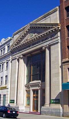 |
(#98001445) |
21 Market St. 41°42′13″N 73°55′47″W / 41.703611°N 73.929722°W |
Poughkeepsie | Well-preserved 1912 neoclassical building; still in use by TD Bank |
| 67 | Poughkeepsie Trust Company | 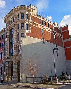 |
(#82001159) |
236 Main St. 41°42′15″N 73°55′47″W / 41.704167°N 73.929722°W |
Poughkeepsie | Beaux Arts building completed in 1906 was Hudson Valley's first skyscraper and had the city's first elevator. Today used as Dutchess County District Attorney's offices. |
| 68 | Poughkeepsie Underwear Factory | 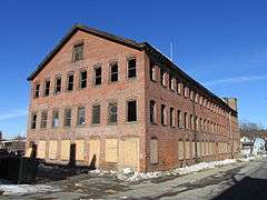 |
(#82001160) |
6-1 N. Cherry St. 41°42′06″N 73°55′06″W / 41.701667°N 73.918333°W |
Poughkeepsie | |
| 69 | Reformed Dutch Church of Poughkeepsie | 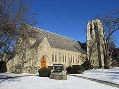 |
(#08000099) |
70 Hooker Ave. 41°41′48″N 73°55′19″W / 41.696667°N 73.921944°W |
Poughkeepsie | |
| 70 | Reynolds House | Upload image | (#82001161) |
107 S. Hamilton St. 41°41′41″N 73°55′35″W / 41.694722°N 73.926389°W |
Poughkeepsie | |
| 71 | Rombout House | 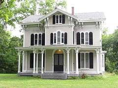 |
(#82001162) |
New Hackensack Rd. 41°40′47″N 73°53′39″W / 41.679722°N 73.894167°W |
Poughkeepsie | |
| 72 | Sague House | 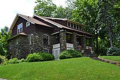 |
(#82001164) |
167 Hooker Ave. 41°41′19″N 73°55′00″W / 41.688611°N 73.916667°W |
Poughkeepsie | Built about 1910 and is a 1½-story, three-bay-wide, bungalow-style dwelling. |
| 73 | St. Paul's Episcopal Church | 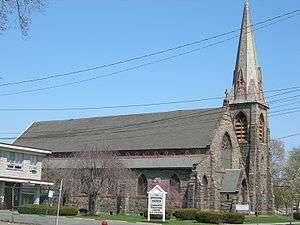 |
(#82001163) |
161 Mansion Street 41°42′24″N 73°55′20″W / 41.706667°N 73.922222°W |
Poughkeepsie | 1870 Norman-Gothic Revival-styled church |
| 74 | Second Baptist Church | 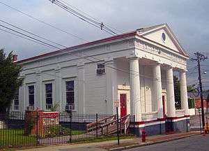 |
(#72000836) |
36 Vassar St. 41°42′23″N 73°55′53″W / 41.706389°N 73.931389°W |
Poughkeepsie | Only Greek Revival church left in city |
| 75 | Shay's Warehouse and Stable |  |
(#87000123) |
Rear of 32 Point St. 41°35′14″N 73°56′58″W / 41.587222°N 73.949444°W |
New Hamburg | 1865 industrial building with Picturesque touches; one of the few industrial buildings remaining in New Hamburg |
| 76 | William Shay Double House | 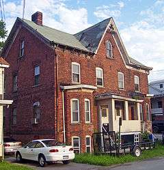 |
(#87000121) |
18 Point St. 41°35′13″N 73°57′00″W / 41.586944°N 73.95°W |
New Hamburg | 1870 duplex is unusually well-decorated and stylish for utilitarian housing in the area |
| 77 | Smith Metropolitan AME Zion Church | 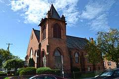 |
(#91001724) |
Junction of Smith and Cottage Sts. 41°42′23″N 73°54′58″W / 41.706389°N 73.916111°W |
Poughkeepsie | Late Gothic Revival church built in 1910 |
| 78 | South Hamilton Street Row |  |
(#82001165) |
81-87 S. Hamilton St. 41°41′48″N 73°55′34″W / 41.696667°N 73.926111°W |
Poughkeepsie | |
| 79 | Stone Street Historic District |  |
(#87000120) |
Stone St. from Division St. to Bridge St. 41°35′19″N 73°56′55″W / 41.588611°N 73.948611°W |
New Hamburg | Short block of intact 19th-century homes |
| 80 | Thompson House | 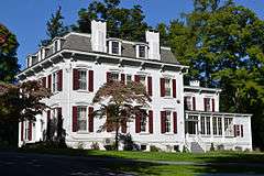 |
(#82001166) |
100 S. Randolph Ave. 41°40′53″N 73°55′14″W / 41.681389°N 73.920556°W |
Poughkeepsie | Second Empire style house built about 1880 |
| 81 | Travis House | 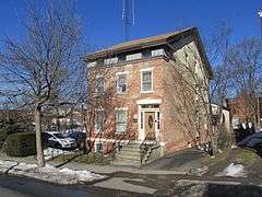 |
(#82001167) |
131 Cannon St. 41°42′03″N 73°55′20″W / 41.700833°N 73.922222°W |
Poughkeepsie | |
| 82 | Trinity Methodist Episcopal Church and Rectory | Upload image | (#82001168) |
1-3 Hooker Ave. 41°41′54″N 73°55′31″W / 41.698333°N 73.925278°W |
Poughkeepsie | Demolished after a fire in 2008 |
| 83 | Union Free School | 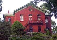 |
(#87000117) |
Academy St. 41°35′21″N 73°56′44″W / 41.589167°N 73.945556°W |
New Hamburg | 1875 school, used until 1940, was only public building in hamlet |
| 84 | Union Street Historic District | 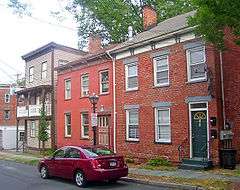 |
(#71000537) |
About 8 blocks in downtown Poughkeepsie centered around Union St. 41°42′14″N 73°56′04″W / 41.703889°N 73.934444°W |
Poughkeepsie | Oldest section of city |
| 85 | Upper-Mill Street Historic District | Upload image | (#82001169) |
Roughly Mill St. from Center Plaza to Catherine St. 41°42′17″N 73°55′34″W / 41.704722°N 73.926111°W |
Poughkeepsie | |
| 86 | US Post Office-Poughkeepsie | 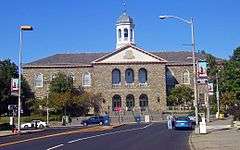 |
(#88002413) |
55 Mansion St.[5] 41°42′26″N 73°55′41″W / 41.707222°N 73.928056°W |
Poughkeepsie | Dedicated in 1937 by President Franklin D. Roosevelt, a Hyde Park native who insisted on preserving the Dutch heritage of the area through the use of fieldstone and was heavily involved in the design process. |
| 87 | Vassar College Observatory |  |
(#91002051) |
Raymond Ave. 41°41′18″N 73°53′36″W / 41.6883°N 73.8933°W |
Poughkeepsie | Workplace and classroom of Maria Mitchell, pioneering American female astronomer |
| 88 | Vassar Home for Aged Men | 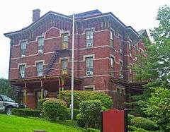 |
(#72000837) |
1 Vassar St. 41°42′19″N 73°55′53″W / 41.705278°N 73.931389°W |
Poughkeepsie | Senior-citizens' home built in 1880 served that purpose for almost a century. Now used by Cunneen-Hackett Arts Center and offices of local non-profit organizations. |
| 89 | Vassar Institute | 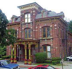 |
(#72001540) |
12 Vassar St. 41°42′20″N 73°55′55″W / 41.705556°N 73.931944°W |
Poughkeepsie | 1882 building is best example of Victorian Italianate Gothic in city. Now used by Cunneen-Hackett Arts Center |
| 90 | Matthew Vassar Estate | 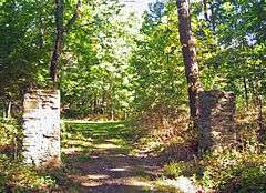 |
(#69000141) |
East off Academy St. below Livingston 41°41′15″N 73°55′41″W / 41.6875°N 73.928056°W |
Poughkeepsie | Known as "Springside". Landscape by Andrew Jackson Downing is his only known surviving work largely as he designed it. |
| 91 | Vassar-Warner Row | 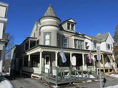 |
(#82001170) |
S. Hamilton from Montgomery to 40 Hamilton St. 41°41′58″N 73°55′30″W / 41.699444°N 73.925°W |
Poughkeepsie | |
| 92 | Violet Avenue School | 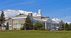 |
(#14000488) |
191 Violet Ave. 41°43′40″N 73°54′43″W / 41.72787°N 73.91185°W |
Poughkeepsie | 1940 stone Colonial Revival elementary school built in close consultation with Franklin D. Roosevelt |
| 93 | Young Men's Christian Association | 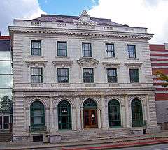 |
(#82001171) |
58 Market St. 41°42′08″N 73°55′49″W / 41.702222°N 73.930278°W |
Poughkeepsie | 1908 building is only glazed terra cotta building in city (only the facade remains). |
| 94 | Zion Memorial Chapel | 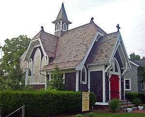 |
(#87000119) |
37 Point St. 41°35′18″N 73°57′00″W / 41.588333°N 73.95°W |
New Hamburg | 1902 chapel is late-stage example of wooden Gothic Revival church |
See also
| Wikimedia Commons has media related to National Register of Historic Places in Poughkeepsie, New York. |
- National Register of Historic Places listings in Dutchess County, New York
- National Register of Historic Places listings in New York
- List of armories and arsenals in New York City and surrounding counties
References
- ↑ The latitude and longitude information provided in this table was derived originally from the National Register Information System, which has been found to be fairly accurate for about 99% of listings. For about 1% of NRIS original coordinates, experience has shown that one or both coordinates are typos or otherwise extremely far off; some corrections may have been made. A more subtle problem causes many locations to be off by up to 150 yards, depending on location in the country: most NRIS coordinates were derived from tracing out latitude and longitudes off of USGS topographical quadrant maps created under the North American Datum of 1927, which differs from the current, highly accurate WGS84 GPS system used by most on-line maps. Chicago is about right, but NRIS longitudes in Washington are higher by about 4.5 seconds, and are lower by about 2.0 seconds in Maine. Latitudes differ by about 1.0 second in Florida. Some locations in this table may have been corrected to current GPS standards.
- ↑ "National Register of Historic Places: Weekly List Actions". National Park Service, United States Department of the Interior. Retrieved on December 2, 2016.
- ↑ Numbers represent an ordering by significant words. Various colorings, defined here, differentiate National Historic Landmarks and historic districts from other NRHP buildings, structures, sites or objects.
- ↑ The eight-digit number below each date is the number assigned to each location in the National Register Information System database, which can be viewed by clicking the number.
- ↑ Address based on USPS website. Accessed March 31, 2016.
| Topics |  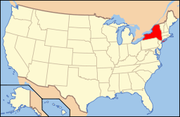 | |
|---|---|---|
| Lists by county |
| |
| Lists by city | ||
| Other lists | ||
| ||
This article is issued from Wikipedia - version of the 10/26/2016. The text is available under the Creative Commons Attribution/Share Alike but additional terms may apply for the media files.