Nerchinsk
| Nerchinsk (English) Нерчинск (Russian) | |
|---|---|
| - Town[1] - | |
|
| |
.svg.png) Location of Zabaykalsky Krai in Russia | |
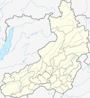 Nerchinsk | |
|
| |
_(1790).png) |
|
|
| |
| Administrative status (as of January 2014) | |
| Country | Russia |
| Federal subject | Zabaykalsky Krai[1] |
| Administrative district | Nerchinsky District[1] |
| Administrative center of | Nerchinsky District[1] |
| Municipal status (as of December 2012) | |
| Municipal district | Nerchinsky Municipal District[2] |
| Urban settlement | Nerchinskoye Urban Settlement[2] |
| Administrative center of | Nerchinsky Municipal District,[3] Nerchinskoye Urban Settlement[4] |
| Statistics | |
| Population (2010 Census) | 14,959 inhabitants[5] |
| Population (January 2014 est.) | 14,775 inhabitants[1] |
| Time zone | YAKT (UTC+09:00)[6] |
| Postal code(s)[7] | 673400, 673402, 673403, 673429, 673840 |
|
| |
| Nerchinsk on Wikimedia Commons | |
Nerchinsk (Russian: Не́рчинск) is a town and the administrative center of Nerchinsky District in Zabaykalsky Krai, Russia, located on the left bank of the Nercha River, 7 kilometers (4.3 mi) above its confluence with the Shilka River, 644 kilometers (400 mi) east of Lake Baikal, about 225 kilometers (140 mi) west of the Chinese border, and 305 kilometers (190 mi) east of Chita, the administrative center of the krai. Population: 14,959 (2010 Census);[5] 15,748 (2002 Census);[8] 16,961 (1989 Census);[9] 6,713 (1897).
Town name in other languages
Two important treaties between the Russian Empire and Manchu China mention Nerchinsk: the 1689 Treaty of Nerchinsk and the 1727 Treaty of Kyakhta. Non-Russian comments on these treaties or on the history of the town may mention other names:
- Latin: Nipchou or Nipcha (however, the Treaty of Kyakhta called the town Nipkoa)
- Manchu: Nibcu hoton
- Chinese: 尼布楚; Pinyin: Níbùchǔ
History
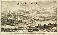
The fort of Nerchinsk dates from 1654. Afanasy Pashkov founded the town four years later; in that year he opened direct communication between the Russian settlements in Transbaikalia and those on the Amur River which had been founded by Cossacks and fur-traders from the Yakutsk region. In 1689 Russia and China signed the Treaty of Nerchinsk, which stopped the farther advance of the Russians into the basin of the Amur for two centuries (see Sino-Russian border conflicts).
After that, Nerchinsk became the chief center for Russian trade with China. The opening of the western route through Mongolia, via Urga, and the establishment of a custom-house at Kyakhta in 1728 diverted this trade into a new channel. But Nerchinsk acquired fresh importance from the influx of immigrants, mostly exiles, into eastern Dauria, from the discovery of rich mines and from the arrival of great numbers of convicts to the Nerchinsk katorga. Ultimately Nerchinsk became the chief town of Transbaikalia.
The famous English adventurer and engineer Samuel Bentham visited Nerchinsk in 1782. Bentham had seen a potential for Nerchinsk as a base for access to the Sea of Okhotsk, provided the Chinese would authorize navigation on the Amur River. Such a venture would have opened up the possibility of fur trade with the Pacific Ocean, as far as the Chinese port of Canton.
In 1812, Nerchinsk was transferred from the banks of the Shilka to its present site, on account of floods. The town relinquished its supremacy to Chita in the late 19th century, when the Trans-Siberian Railway bypassed it.
According to George Kennan, "a few of the Decembrist conspirators of 1825" and "thousands of Polish insurgents" from their unsuccessful insurrection of 1863" were transported to the Nerchinsk silver-mining district.[10]
20th century
In the early 20th century, Nerchinsk was built of wood, and its lower areas frequently suffered from inundations. The inhabitants supported themselves mainly by agriculture, tobacco-growing and cattle-breeding; a few merchants traded in furs and cattle, in brick-tea from China, and in manufactured wares from Russia. Gold-mines in the vicinity were owned and developed by the Butin family of merchants, whose Neo-Moorish palace now stands in disrepair.
Nerchinsk today
As of 2016 Nerchinsk is home to some small electromechanical and food-processing industries. It has a small museum, established in 1884. Among its sights are the Resurrection Cathedral, built in the Neoclassical style in 1825 to commemorate the city's relocation, its belltower destroyed by the Communists. The site of old Nerchinsk is marked by the Assumption Monastery, the oldest in Dauria, founded in 1664. Its cathedral, consecrated in 1712, is the easternmost building in the Muscovite Baroque style.
Administrative and municipal status
Within the framework of administrative divisions, Nerchinsk serves as the administrative center of Nerchinsky District, to which it is directly subordinated.[1] As a municipal division, the town of Nerchinsk, together with one rural locality (the selo of Makeyevka), is incorporated within Nerchinsky Municipal District as Nerchinskoye Urban Settlement.[2]
Transportation
| Nerchinsk | |||||||||||
|---|---|---|---|---|---|---|---|---|---|---|---|
| IATA: none – ICAO: none | |||||||||||
| Summary | |||||||||||
| Airport type | Military | ||||||||||
| Operator | Russian Air Force | ||||||||||
| Location | Nerchinsk | ||||||||||
| Elevation AMSL | 1,575 ft / 480 m | ||||||||||
| Coordinates | 52°0′0″N 116°32′0″E / 52.00000°N 116.53333°E | ||||||||||
| Runways | |||||||||||
| |||||||||||
The Nerchinsk Airport is a former air-base located 2 kilometers (1.2 mi) northwest of the town. It appears to be abandoned. The substandard runway length suggests a 1950s design.
References
Notes
- 1 2 3 4 5 6 Registry of the Administrative-Territorial Units and the Inhabited Localities of Zabaykalsky Krai
- 1 2 3 Law #317-ZZK
- ↑ Law #316-ZZK
- ↑ Федеральная служба государственной статистики. Федеральное агентство по технологическому регулированию и метрологии. №ОК 033-2013 1 января 2014 г. «Общероссийский классификатор территорий муниципальных образований. Код 76 628 101». (Federal State Statistics Service. Federal Agency on Technological Regulation and Metrology. #OK 033-2013 January 1, 2014 Russian Classification of Territories of Municipal Formations. Code 76 628 101. ).
- 1 2 Russian Federal State Statistics Service (2011). "Всероссийская перепись населения 2010 года. Том 1" [2010 All-Russian Population Census, vol. 1]. Всероссийская перепись населения 2010 года (2010 All-Russia Population Census) (in Russian). Federal State Statistics Service. Retrieved June 29, 2012.
- ↑ Правительство Российской Федерации. Федеральный закон №107-ФЗ от 3 июня 2011 г. «Об исчислении времени», в ред. Федерального закона №271-ФЗ от 03 июля 2016 г. «О внесении изменений в Федеральный закон "Об исчислении времени"». Вступил в силу по истечении шестидесяти дней после дня официального опубликования (6 августа 2011 г.). Опубликован: "Российская газета", №120, 6 июня 2011 г. (Government of the Russian Federation. Federal Law #107-FZ of June 31, 2011 On Calculating Time, as amended by the Federal Law #271-FZ of July 03, 2016 On Amending Federal Law "On Calculating Time". Effective as of after sixty days following the day of the official publication.).
- ↑ Почта России. Информационно-вычислительный центр ОАСУ РПО. (Russian Post). Поиск объектов почтовой связи (Postal Objects Search) (Russian)
- ↑ Russian Federal State Statistics Service (May 21, 2004). "Численность населения России, субъектов Российской Федерации в составе федеральных округов, районов, городских поселений, сельских населённых пунктов – районных центров и сельских населённых пунктов с населением 3 тысячи и более человек" [Population of Russia, Its Federal Districts, Federal Subjects, Districts, Urban Localities, Rural Localities—Administrative Centers, and Rural Localities with Population of Over 3,000] (XLS). Всероссийская перепись населения 2002 года [All-Russia Population Census of 2002] (in Russian). Retrieved August 9, 2014.
- ↑ Demoscope Weekly (1989). "Всесоюзная перепись населения 1989 г. Численность наличного населения союзных и автономных республик, автономных областей и округов, краёв, областей, районов, городских поселений и сёл-райцентров" [All Union Population Census of 1989: Present Population of Union and Autonomous Republics, Autonomous Oblasts and Okrugs, Krais, Oblasts, Districts, Urban Settlements, and Villages Serving as District Administrative Centers]. Всесоюзная перепись населения 1989 года [All-Union Population Census of 1989] (in Russian). Институт демографии Национального исследовательского университета: Высшая школа экономики [Institute of Demography at the National Research University: Higher School of Economics]. Retrieved August 9, 2014.
- ↑ Kennan, George (1891). Siberia and the Exile System. London: James R. Osgood, McIlvaine & Co. p. 280.
Sources
- Министерство территориального развития Забайкальского края. 1 января 2014 г. «Реестр административно-территориальных единиц и населённых пунктов Забайкальского края», в ред. Распоряжения №209-р от 10 июня 2014 г.. (Ministry of the Territorial Development of Zabaykalsky Krai. January 1, 2014 Registry of the Administrative-Territorial Units and the Inhabited Localities of Zabaykalsky Krai, as amended by the Directive #209-r of June 10, 2014. ).
- Законодательное Собрание Забайкальского края. Закон №317-ЗЗК от 18 декабря 2009 г. «О границах сельских и городских поселений Забайкальского края», в ред. Закона №1070-ЗЗК от 31 октября 2014 г. «О внесении изменений в Закон Забайкальского края "О границах сельских и городских поселений Забайкальского края"». Вступил в силу через десять дней после дня официального опубликования. Опубликован: "Забайкальский рабочий", №239–242, 21 декабря 2009 г. (Legislative Assembly of Zabaykalsky Krai. Law #317-ZZK of December 18, 2009 On the Borders of the Rural and Urban Settlements of Zabaykalsky Krai, as amended by the Law #1070-ZZK of October 31, 2014 On Amending the Law of Zabaykalsky Krai "On the Borders of the Rural and Urban Settlements of Zabaykalsky Krai". Effective as of the day which is ten days after the day of the official publication.).
- Законодательное Собрание Забайкальского края. Закон №316-ЗЗК от 18 декабря 2009 г. «О границах муниципальных районов и городских округов Забайкальского края», в ред. Закона №770-ЗЗК от 26 декабря 2012 г. «О внесении изменений в Закон Забайкальского края "О границах муниципальных районов и городских округов Забайкальского края"». Вступил в силу через десять дней после дня официального опубликования. Опубликован: "Забайкальский рабочий", №239–242, 21 декабря 2009 г. (Legislative Assembly of Zabaykalsky Krai. Law #316-ZZK of December 18, 2009 On the Borders of the Municipal Districts and Urban Okrugs of Zabaykalsky Krai, as amended by the Law #770-ZZK of December 26, 2012 On Amending the Law of Zabaykalsky Krai "On the Borders of the Municipal Districts and Urban Okrugs of Zabaykalsky Krai". Effective as of the day which is ten days after the day of the official publication.).
 This article incorporates text from a publication now in the public domain: Chisholm, Hugh, ed. (1911). "article name needed". Encyclopædia Britannica (11th ed.). Cambridge University Press.