Chita, Zabaykalsky Krai
| Chita (English) Чита (Russian) | |
|---|---|
| - City[1] - | |
.JPG) Lenin Square | |
.svg.png) Location of Zabaykalsky Krai in Russia | |
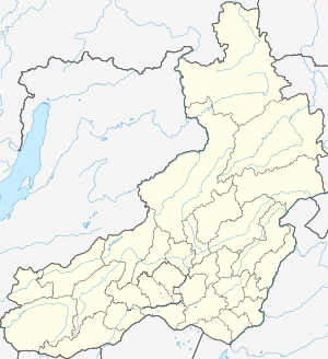 Chita | |
|
| |
.png) |
|
|
| |
| Administrative status (as of January 2012) | |
| Country | Russia |
| Federal subject | Zabaykalsky Krai[1] |
| Administrative district | Chitinsky District[1] |
| Administrative center of | Zabaykalsky Krai,[1] Chitinsky District[1] |
| Municipal status (as of December 2009) | |
| Urban okrug | Chita Urban Okrug[2] |
| Administrative center of | Chita Urban Okrug[2] |
| Mayor | Anatoly Mikhalyov |
| Statistics | |
| Population (2010 Census) | 324,444 inhabitants[3] |
| - Rank in 2010 | 56th |
| Time zone | YAKT (UTC+09:00)[4] |
| Founded | 1653[5] |
| City status since | July 11, 1851 |
| Postal code(s)[6] | 672000–672051 |
| Dialing code(s) | +7 3022 |
|
| |
| Chita on Wikimedia Commons | |
Chita (Russian: Чита; IPA: [tɕɪˈta]) is a city and the administrative center of Zabaykalsky Krai, Russia, located at the confluence of the Chita and Ingoda Rivers and on the Trans-Siberian Railway,[7] 900 kilometers (560 mi) east of Irkutsk. Population: 324,444 (2010 Census);[3] 316,643 (2002 Census);[8] 365,754 (1989 Census).[9]
History
Before 1825
For several centuries before the Russians arrived, local Mongolic and Turkic tribes inhabited the Chita region, along with various Chinese traders.
Pyotr Beketov's Cossacks founded Chita in 1653.[5][10]
1825 to 1918
After 1825, several of the Decembrists suffered exile to Chita;[7] thus, Chita is on occasion called the "City of Exiles". Many of the Decembrists were intellectuals and members of the middle class, and consequently their arrival had a positive effect.
According to George Kennan, "Among the exiles in Chita were some of the brightest, most cultivated, most sympathetic men and women that we had met in Eastern Siberia."[11]
Chita was granted town status on July 11, 1851.
When Richard Maack visited the city in 1855, he saw a wooden town, with one, also wooden, church. He estimated Chita's population at under 1,000, but predicted that the city would soon experience fast growth, due to the upcoming annexation of the Amur valley by Russia. [12]
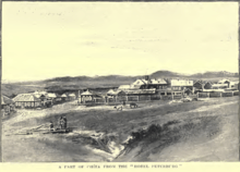
By 1885, Chita's population had reached 5,728, and by 1897 it increased to 11,500.[10]
At the end of the 19th century, many Muslims settled in Chita, attracted by its trading potential. These Muslims were mainly of Tatar origin. They settled down near the Jewish quarter and built a mosque. Many Tatars living in Chita descend from these immigrants.

1918 to 1945

Chita was occupied by the Japanese between 1918 and 1920. From 1920 to 1922, Chita served as the capital of the Far Eastern Republic. From the 1930s to the dissolution of the Soviet Union, Chita was a closed city. During this period, foreigners were prohibited from traveling to Chita, as were many Russians.
Post-1945
In 1945, Puyi, the last Emperor of China, and some of his associates were held prisoner in the city, in a former sanatorium for officers.[13]
Administrative and municipal status
Chita is the administrative center of Zabaykalsky Krai, and, within the framework of administrative divisions, it also serves as the administrative center of Chitinsky District, to which it is also subordinated.[1] As a municipal division, the city of Chita together with one rural locality in Chitinsky District is incorporated as Chita Urban Okrug.[14]
City districts
The city is subdivided into four administrative districts: Chernovsky (named after the Chernovskiye coal mines and colloquially known as "Chernovskiye"[15]), Ingodinsky (named after the Ingoda River), Tsentralny, and Zheleznodorozhny.
Chernovsky Administrative District used to be a mining settlement, which was incorporated into Chita in 1941.[16] Chernovskiye mines themselves are a geological nature monument of international status.[17]
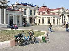
Transportation
The Trans-Siberian Highway passes through Chita. Two sections of the highway connect in Chita: the M55 Baikal Highway, which goes from Chita to Irkutsk, and the M58 Amur Highway, which goes from Chita to Khabarovsk.
Chita is served by Kadala Airport, situated 15km to the west.[18]
Education
Chita is home to several facilities of higher education:
- Transbaikal State University (formerly Chita State University)
- Chita State Academy of Medicine
Military
Chita Northwest air base is located nearby, as well as the 101st (Hub) Communications Brigade and the 53rd Material Support Regiment.
Sports
FC Chita is Chita's association football club.
An indoor arena for speed skating is planned.[19]
Climate
Chita experiences a borderline subarctic climate/humid continental climate (Köppen Dwc/Dwb) with very cold, very dry winters and warm, wet summers.
| Climate data for Chita (1981–2010) | |||||||||||||
|---|---|---|---|---|---|---|---|---|---|---|---|---|---|
| Month | Jan | Feb | Mar | Apr | May | Jun | Jul | Aug | Sep | Oct | Nov | Dec | Year |
| Record high °C (°F) | 0.4 (32.7) |
7.4 (45.3) |
18.3 (64.9) |
29.3 (84.7) |
36.9 (98.4) |
43.2 (109.8) |
43.0 (109.4) |
40.9 (105.6) |
35.0 (95) |
26.0 (78.8) |
12.7 (54.9) |
5.0 (41) |
43.2 (109.8) |
| Average high °C (°F) | −17.6 (0.3) |
−10.0 (14) |
−0.7 (30.7) |
9.1 (48.4) |
17.8 (64) |
24.3 (75.7) |
25.9 (78.6) |
23.0 (73.4) |
16.4 (61.5) |
6.8 (44.2) |
−6.0 (21.2) |
−15.4 (4.3) |
6.1 (43) |
| Daily mean °C (°F) | −25.2 (−13.4) |
−19.2 (−2.6) |
−9 (16) |
1.6 (34.9) |
9.7 (49.5) |
16.4 (61.5) |
18.7 (65.7) |
16.0 (60.8) |
8.7 (47.7) |
−0.4 (31.3) |
−12.6 (9.3) |
−21.9 (−7.4) |
−1.4 (29.5) |
| Average low °C (°F) | −31.2 (−24.2) |
−27.1 (−16.8) |
−16.9 (1.6) |
−5.5 (22.1) |
1.6 (34.9) |
8.7 (47.7) |
12.3 (54.1) |
10.1 (50.2) |
2.3 (36.1) |
−6.2 (20.8) |
−18.3 (−0.9) |
−27.3 (−17.1) |
−8.1 (17.4) |
| Record low °C (°F) | −49.6 (−57.3) |
−48.0 (−54.4) |
−45.3 (−49.5) |
−29.6 (−21.3) |
−13.3 (8.1) |
−5.4 (22.3) |
0.1 (32.2) |
−3.0 (26.6) |
−10.8 (12.6) |
−33.1 (−27.6) |
−41.1 (−42) |
−47.8 (−54) |
−49.6 (−57.3) |
| Average precipitation mm (inches) | 3 (0.12) |
2 (0.08) |
3 (0.12) |
12 (0.47) |
26 (1.02) |
63 (2.48) |
90 (3.54) |
89 (3.5) |
41 (1.61) |
9 (0.35) |
6 (0.24) |
5 (0.2) |
349 (13.74) |
| Average rainy days | 0 | 0 | 1 | 5 | 11 | 16 | 18 | 17 | 13 | 5 | 0.2 | 0 | 86 |
| Average snowy days | 15 | 9 | 8 | 7 | 3 | 0.03 | 0 | 0 | 1 | 7 | 11 | 15 | 76 |
| Average relative humidity (%) | 76 | 72 | 59 | 47 | 46 | 58 | 68 | 73 | 66 | 61 | 70 | 77 | 64 |
| Mean monthly sunshine hours | 139 | 179 | 239 | 242 | 277 | 279 | 247 | 226 | 212 | 190 | 134 | 108 | 2,472 |
| Source #1: Pogoda.ru.net[20] | |||||||||||||
| Source #2: NOAA (sun, 1961–1990)[21] | |||||||||||||
Twin towns and sister cities
Chita is twinned with:
 Boise, Idaho, United States
 Ulan-Ude, Russia; from 2011[22]
 Manzhouli, China; from 1999[23]
- Abilene, Texas,[24] United States; from 1996
 Choibalsan, Mongolia; from 1995
 Chita, Japan; from 1994
- Hailar District, China; from 1992
Notable people
- Aleksandra Samusenko (1922-1945), Soviet Tank Captain, Sole female tankman in 1st Guards Tank Army
- Yevgeni Alkhimov (born 1977), Russian professional footballer
- Oleg Lundstrem (1916–2005), Soviet and Russian jazz composer
- Igor Mirnov (born 1984), Russian professional ice hockey player
- Ivan Nagibin (born 1986), Russian professional football player
- Lev Okhotin (1911–1948), member of the Supreme Council of the Russian Fascist Party
- Aleksandr Perfilyev (1895–1973), Russian journalist, poet and writer
- Anastasia Pivovarova (born 1990), Russian professional tennis player
- Boris Polevoy (1918–2002), Russian historian
- Volodymyr Shkidchenko (born 1948), Ukrainian military, General of Army of Ukraine
- Sergei Smirnov (born 1950), Russian security services official
- Anatoly Sobchak (1937–2000), Russian politician
- Vitaly Solomin (1941–2002), Soviet and Russian actor, director and screenwriter
- Yury Solomin (born 1935), Soviet and Russian actor and director
- Alina Stadnik (born 1991), Ukrainian female wrestler
- Alexander Stranichkin (born 1955), Abkhazian politician
- Lyudmila Titova (born 1946), Russian speed skater
- Dmytro Tymchuk (born 1972), Ukrainian military expert and blogger
- Yemelyan Yaroslavsky (1878–1943), Russian revolutionary, Soviet politician, communist party organizer
References
Notes
- 1 2 3 4 5 6 Registry of the Administrative-Territorial Units and the Inhabited Localities of Zabaykalsky Krai
- 1 2 Law #316-ZZK
- 1 2 Russian Federal State Statistics Service (2011). "Всероссийская перепись населения 2010 года. Том 1" [2010 All-Russian Population Census, vol. 1]. Всероссийская перепись населения 2010 года (2010 All-Russia Population Census) (in Russian). Federal State Statistics Service. Retrieved June 29, 2012.
- ↑ "Current local time in Chita, Russia". Time and Date. Retrieved 18 January 2015.
- 1 2 Howard Amos (March 3, 2013). "Chita: China's Back Door to Russia". The Moscow Times. Retrieved December 15, 2013.
- ↑ Почта России. Информационно-вычислительный центр ОАСУ РПО. (Russian Post). Поиск объектов почтовой связи (Postal Objects Search) (Russian)
- 1 2
 Chisholm, Hugh, ed. (1911). "Chita". Encyclopædia Britannica. 6 (11th ed.). Cambridge University Press. p. 247.
 - ↑ Russian Federal State Statistics Service (May 21, 2004). "Численность населения России, субъектов Российской Федерации в составе федеральных округов, районов, городских поселений, сельских населённых пунктов – районных центров и сельских населённых пунктов с населением 3 тысячи и более человек" [Population of Russia, Its Federal Districts, Federal Subjects, Districts, Urban Localities, Rural Localities—Administrative Centers, and Rural Localities with Population of Over 3,000] (XLS). Всероссийская перепись населения 2002 года [All-Russia Population Census of 2002] (in Russian). Retrieved August 9, 2014.
- ↑ Demoscope Weekly (1989). "Всесоюзная перепись населения 1989 г. Численность наличного населения союзных и автономных республик, автономных областей и округов, краёв, областей, районов, городских поселений и сёл-райцентров" [All Union Population Census of 1989: Present Population of Union and Autonomous Republics, Autonomous Oblasts and Okrugs, Krais, Oblasts, Districts, Urban Settlements, and Villages Serving as District Administrative Centers]. Всесоюзная перепись населения 1989 года [All-Union Population Census of 1989] (in Russian). Институт демографии Национального исследовательского университета: Высшая школа экономики [Institute of Demography at the National Research University: Higher School of Economics]. Retrieved August 9, 2014.
- 1 2 Энциклопедия Города России. Moscow: Большая Российская Энциклопедия. 2003. p. 519. ISBN 5-7107-7399-9.
- ↑ Kennan, George (1891). Siberia and the Exile System. London: James R. Osgood, McIlvaine & Co. p. 336.
- ↑ Maack, Richard Karlovich (Ричард Карлович Маак) (1859), Путешествие на Амур, совершенное по распоряжению Сибирскаго Отдѣла Императорскаго Русскаго Географическаго Общества, в 1855 году: Один том, с портретом графа Муравьева-Амурскаго и с отдѣлельным собранием рисунков, карт и планов (The travel to the Amur, carried out on orders of the Siberian Division of the Russian Imperial Georgraphic Society in 1855...), Изд. члена-соревнователя Сибирскаго отдѣла С. Ф. Соловьева, p. 23
- ↑ S. I. Kuznetsov and S. V. Karasov, "The Last Emperor of China: Internment in the Soviet Union", The Journal of Slavic Military Studies 18(2), 207-226 (2005). doi:10.1080/13518040590944430
- ↑ The Registry of the Administrative-Territorial Units and the Inhabited Localities lists one city, three urban-type settlements, and fifty-four rural localities in Chitinsky District. The city of Chita and one rural locality are listed as a part of Chita Urban Okrug in Law #316-ZZK.
- ↑ Как развивался и приходил в упадок Черновский район Читы
- ↑ "Государственный архив Забайкальского края. Фонд: Черновский райисполком"
- ↑ "Черновские Копи"
- ↑ "Chita: Flights". Lonely Planet. Retrieved 18 December 2015.
- ↑ https://translate.google.com/translate?hl=en&sl=ru&u=http://news.chita.ru/44490/&prev=search
- ↑ "Weather and Climate-The Climate of Chita" (in Russian). Weather and Climate (Погода и климат). Retrieved 11 April 2016.
- ↑ "Cita/Kadala (Chita) Climate Normals 1961–1990". National Oceanic and Atmospheric Administration. Retrieved 11 April 2016.
- ↑ Zabinfo: CHITA and ULAN UDE is twin towns
- ↑ Encyclopedia of Transbaikal Region. Twinning towns
- ↑ Coe, Andre (April 25, 2000). "Abilene gives Western farewell to delegates from new sister city". Abilene Reporter-News. Archived from the original on February 26, 2005. Retrieved September 21, 2013.
Sources
- Министерство территориального развития Забайкальского края. 1 января 2014 г. «Реестр административно-территориальных единиц и населённых пунктов Забайкальского края», в ред. Распоряжения №209-р от 10 июня 2014 г.. (Ministry of the Territorial Development of Zabaykalsky Krai. January 1, 2014 Registry of the Administrative-Territorial Units and the Inhabited Localities of Zabaykalsky Krai, as amended by the Directive #209-r of June 10, 2014. ).
- Законодательное Собрание Забайкальского края. Закон №316-ЗЗК от 18 декабря 2009 г. «О границах муниципальных районов и городских округов Забайкальского края», в ред. Закона №770-ЗЗК от 26 декабря 2012 г. «О внесении изменений в Закон Забайкальского края "О границах муниципальных районов и городских округов Забайкальского края"». Вступил в силу через десять дней после дня официального опубликования. Опубликован: "Забайкальский рабочий", №239–242, 21 декабря 2009 г. (Legislative Assembly of Zabaykalsky Krai. Law #316-ZZK of December 18, 2009 On the Borders of the Municipal Districts and Urban Okrugs of Zabaykalsky Krai, as amended by the Law #770-ZZK of December 26, 2012 On Amending the Law of Zabaykalsky Krai "On the Borders of the Municipal Districts and Urban Okrugs of Zabaykalsky Krai". Effective as of the day which is ten days after the day of the official publication.).
- This article incorporates text from a publication now in the public domain: Chisholm, Hugh, ed. (1911). "Chita". Encyclopædia Britannica. 6 (11th ed.). Cambridge University Press. p. 247.
External links
- Official website of Chita (Russian)
- Account of Englishman's life in Chita, 2005-2006
- Old Chita, website of local history (Russian)