Nerul
| Nerul नेरूळ | |
|---|---|
| Node /Locale | |
|
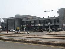
Buildings in Nerul,Mumbai as seen from the Palm beach road | |
| Coordinates: 19°01′59″N 73°01′12″E / 19.033°N 73.020°ECoordinates: 19°01′59″N 73°01′12″E / 19.033°N 73.020°E | |
| Country |
|
| State | Maharashtra |
| District | Mumbai |
| Metro | Mumbai |
| Languages | |
| • Official | Marathi |
| Vidhan Sabha constituency | Navi Mumbai |
| Airport | BOM CSIA, Mumbai |
Nerul is a residential and commercial node of the city of Mumbai. It consists of more than 50 sectors. Nerul East houses odd sectors while Nerul West includes even sectors. It is one of the biggest, and most populated residential nodes of the city.
Nerul along with Seawoods is the second most developed zone of New Mumbai after Vashi. Nerul along with Seawoods-Dharave is one of the most expensive, promising and developing realty locales in the satellite city. Nerul has a huge floating and residential population moving in from South Mumbai and the western suburbs, making it more upmarket by the day.
Nerul however still has parts with an intrinsic rustic feel about it. The estimated population of Nerul is around 10,00,000. Nerul is the only node that has two railway stations namely Nerul railway station and Seawoods–Dharave railway station. About one lakh people travel from Nerul and 50,000 from Seawoods–Dharave railway station.
Educational institutions
- DAV Public School Nerul
- Ramrao Adik Institute of Technology
- Terna Engineering College
- St. Xavier's High School and Junior College of Science
- St. Augustines High School, Nerul
- SIES College of Arts, Science & Commerce
- Apeejay School Nerul
- MGM High School Nerul
- Delhi Public School, Nerul|Delhi Public School
- SBOA Public school Nerul (the best in the east)
Transport

A major part of the Palm Beach Road and Sion - Panvel Highway passes through Nerul.
The township like the rest of Navi Mumbai is divided into sectors, which are further divided into plots. As such, the address system is more organized and the township easy to navigate compared to central Mumbai, hence minimizing traffic. Nerul, being a planned township, features roads that intersect at right angles.
Auto rickshaws provide the primary means of personal local transportation. Travelling to other nodes by auto rickshaw usually entails the payment of one-and-a-half times the regular meter fare, or some other negotiated fare hike. AC bus facility has been made available by NMMT bus service. BEST and NMMT buses serve as a much cheaper means of transport. Buses starting from or passing through Nerul allow passengers direct and fast passage to destinations across Mumbai.
Nerul is connected by rail on the harbour line, part of the Mumbai Suburban Railway. Travelling to destinations across Mumbai by rail often involves taking a train to the Chhatrapati Shivaji Terminus (CST). Services from Nerul to Thane has been started some years ago to reduce the crowd at Kurla.
Infrastructure
The water supply is near constant for 10–11 months annually and the month of May has peak shortages. Occasional shut downs are often short enough to be borne through by the overhead water tanks in many apartments and the central water tower system.
Road maintenance is carried out by the NMMC. Roads in the township are generally of good quality, but often get damaged by the monsoons, as potholes are simply patched up. Maintenance of open spaces too is sadly lacking, with most open spaces resembling piles of rubble.
Sports

Nerul is famous for its various sports complexes. The DY Patil Stadium is one such complex which includes a world-class cricket stadium. Some of the DLF IPL matches were held here in the year 2010. There is also Nerul Gymkhana with a lot of facilities for sports. A Golf course is coming up soon in Nerul. It is also known as DYPSA (D Y Patil Sports Academy).
Places to visit
Nerul has many places to visit both for children as well as the adults. There are a number of gardens among which The Rock Garden [1] in Nerul (East) is a very popular spot for all age group of people. Also there is a small amusement park called the Wonders Park [2] in Nerul (East) close to the Uran road. There is Parsik Hills.
in Nerul (West) is a hill with temples and church. Also there is the D Y Patil Stadium in Nerul(East) near the Sion-Panvel Express Highway.
References
External links
| Wikimedia Commons has media related to Nerul. |
-
 Navi Mumbai travel guide from Wikivoyage
 - Nerul Information
