Nevada State Route 374
| ||||
|---|---|---|---|---|
| Death Valley Road | ||||
| Route information | ||||
| Maintained by NDOT | ||||
| Length: | 8.840 mi[1] (14.227 km) | |||
| Existed: | 1976 – present | |||
| Major junctions | ||||
| South end: | Death Valley Nat'l Park boundary | |||
| North end: |
| |||
| Highway system | ||||
| ||||

State Route 374 (SR 374) is a state highway in Nye County, Nevada, United States. It serves as Nevada's gateway to Death Valley National Park, connecting the park to Beatty. The highway was known as State Route 58 prior to 1976.
Route description
_in_Beatty%2C_Nevada.jpg)
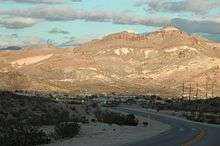
SR 374 begins at the boundary to the Nevada portion of Death Valley National Park in Nye County. From there, it runs due northeast across the open desert. The route curves eastward as it passes through the mountains southwest of Beatty. The road becomes Main Street as it enters the town's southern limits. The route ends at US 95, where Main Street intersects Second Street. The route terminates in the northwest regions of the Amargosa Desert, and Amargosa Valley.
History

The highway first appeared on Nevada state highway maps as State Route 58 in 1937.[2]
In the 1976 renumbering of Nevada's state highways, the route was reassigned to SR 374.[3] The number change was first seen on state maps in 1978.[4]
Major intersections
The entire route is in Nye County.
| Location | mi[5] | km | Destinations | Notes | |
|---|---|---|---|---|---|
| | 0.00 | 0.00 | Death Valley Road | Continuation beyond terminus; Death Valley National Park boundary | |
| Beatty | 8.84 | 14.23 | |||
| 1.000 mi = 1.609 km; 1.000 km = 0.621 mi | |||||
See also
 Nevada portal
 U.S. Roads portal
References
- ↑ Nevada Department of Transportation (January 2008). "Nevada State Maintained Highways: Descriptions, Index and Maps". Retrieved 2008-12-17.
- ↑ Official Road Map of the State of Nevada (Map). Nevada State Highway Department. 1937. Retrieved 2008-12-17.
- ↑ Nevada State Maintained Highways: Descriptions, Index and Maps. Nevada Department of Transportation. January 2001. p. 112.
- ↑ Official Highway Map of Nevada (Map) (1978-79 ed.). Nevada Department of Highways. 1978. § F4. Retrieved 2009-01-14.
- ↑ Nevada Department of Transportation (May 2008). "Maps of Milepost Location on Nevada's Federal and State Highway System by County" (PDF). Retrieved 2009-01-14.
External links
 Media related to Nevada State Route 374 at Wikimedia Commons
- AARoads: Nevada 374