Death Valley Junction, California
| Death Valley Junction | |
|---|---|
| Unincorporated community | |
|
Old buildings in the Historic District | |
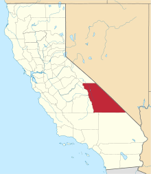
 Death Valley Junction Location in California | |
| Coordinates: 36°18′08″N 116°24′49″W / 36.30222°N 116.41361°WCoordinates: 36°18′08″N 116°24′49″W / 36.30222°N 116.41361°W | |
| Country | United States |
| State | California |
| County | Inyo County |
| Elevation[1] | 2,041 ft (622 m) |
| FIPS code | 06-18212 |
| GNIS feature ID | 1656477 |
|
Death Valley Junction Historic District | |
|
| |
  | |
| Location | CA 127 and CA 190, Death Valley Junction, California |
| Built | 1923 |
| Architect | Alexander H. McCulloch |
| Architectural style | Mission/Spanish Revival |
| NRHP Reference # | 80000802[2] |
| Added to NRHP | December 10, 1980 |
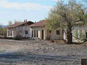
Death Valley Junction (formerly, Amargosa[1] and Death Valley[3]) is a tiny Mojave Desert community in unincorporated community Inyo County, California, at the intersection of SR 190 and SR 127, just east of Death Valley National Park. The zip code is 92328, the elevation is 2,041 ft (622 m), and the population fewer than 20. The city limits sign reports a population of 4. The U.S. Geological Survey lists a historic variant name of Amargosa for the community which is shown as the primary name on an official State of Nevada map from 1971. The default format for wired phone numbers in this community is (760) 852-xxxx.
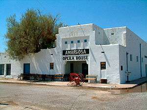
Death Valley Junction is home to the Amargosa Opera House and Hotel, where resident Marta Becket staged dance and mime shows from the late 1960s until her last show in February 2012.[4] The hotel is still operating next to the opera house, but beyond these maintained areas, the town is in a state of disrepair. There are no gas stations, and only one restaurant. The single restaurant, T&T Cafe, is part of the Amargosa Opera House and Hotel, but is not run by the hotel staff.
The community's location, 27 miles (43 km) east-southeast of Furnace Creek Inn,[3] on the east side of Death Valley is south of Nevada's Amargosa Valley and near Ash Meadows National Wildlife Refuge. East/South East, 27 miles, is Pahrump, Nevada. South on SR127 is the town of Shoshone, California. The closest straight-line distance to the Nevada state line is roughly five miles northeast.
Government documents show an effort by the Timbisha Shoshone tribal government to acquire about 7,200 acres (29 km2) in the area during 1999 to 2000. This includes areas for residences and the official federal sanction to use some government lands for traditional ceremonies. It's unclear if these efforts, which were documented in the Congressional Record, succeeded.
History
In 1914, the Death Valley Railroad started operating between Ryan, California and Death Valley Junction. It carried borax until 1928, when operations ceased. The name of the town was changed to Death Valley Junction from Amargosa (bitter in Spanish, most likely meaning "bitter water", as the Spanish words agua and amargosa are feminine). From 1923 to 1925 the Pacific Coast Borax Company constructed buildings in the town, hiring architect Alexander Hamilton McCulloch to design a Spanish Colonial Revival whistle stop centered at the hotel, theater and office complex building, now known as the Amargosa Opera House and Hotel.
The town began to decline in the mid-20th century. However, in 1967 dancer and actress Marta Becket happened to visit due to an automobile repair.[5] She became enamored with the theater, and with help from benefactors, she leased, then purchased, the hotel and theater complex. The Amargosa is now owned by a non-profit organization.
The Death Valley post office opened in 1908 and transferred to Furnace Creek Ranch in 1961.[3] The Amargosa post office opened in 1962, changed its name to Death Valley Junction in 1968.[3]
In 1980 the town was included in the National Register of Historic Places as the "Death Valley Junction Historic District."
When the Death Valley Railroad was established in 1914, it used 3.19 miles (5.13 km) of tracks belonging to the Tonopah and Tidewater Railroad east-southeast of Death Valley Junction to Horton.[3]
Telephone history
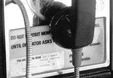
Local wired telephones were manual telephone service until the 1980s. To reach a phone in Death Valley Junction when the area was under manual service required dialing the operator and asking for "Death Valley Junction, California, Toll Station" (and the one-digit number). Placing an outbound call required lifting the receiver and waiting for an operator. The operator who answered was in Los Angeles (over 150 miles away). Death Valley Junction is now in area codes 442 and 760.
Politics
In the state legislature, Death Valley Junction is in the 18th Senate District, represented by Democrat Robert Hertzberg,[6] and the 26th Assembly District, represented by Republican Devon Mathis.[7]
Federally, Death Valley Junction is in California's 8th congressional district, represented by Republican Paul Cook.[8]
Notable people
- Marta Becket - retired actress, dancer, choreographer and painter
- The Undertaker - WWE wrestler is billed from here
References
- 1 2 U.S. Geological Survey Geographic Names Information System: Death Valley Junction, California
- ↑ National Park Service (2008-04-15). "National Register Information System". National Register of Historic Places. National Park Service.
- 1 2 3 4 5 Durham, David L. (1998). California's Geographic Names: A Gazetteer of Historic and Modern Names of the State. Clovis, Calif.: Word Dancer Press. p. 1159. ISBN 1-884995-14-4.
- ↑ Charlene Dean (10 February 2012). "Soiree Planned for Becket's Final Stage Performance". Pahrump Valley Times. Pahrump Valley Times. Retrieved 15 April 2012.
- ↑ "S.Y. Valley to help preserve theater". Santa Maria Times. Retrieved 2008-07-03.
- ↑ "Senators". State of California. Retrieved April 11, 2013.
- ↑ "Members Assembly". State of California. Retrieved April 11, 2013.
- ↑ "California's 8th Congressional District - Representatives & District Map". Civic Impulse, LLC. Retrieved April 11, 2013.
External links
| Wikimedia Commons has media related to Death Valley Junction, California. |
- The town that Zane Grey helped build
- The Amargosa Opera House and Hotel
- The Amargosa Opera House Museum Fund
- Ghost Towns of Death Valley: Death Valley Junction
| Topics | |
|---|---|
| Lists by states |
|
| Lists by insular areas | |
| Lists by associated states | |
| Other areas | |
| |