Racetrack Playa
| Racetrack Playa | |
|---|---|
 | |
| Location |
Death Valley National Park Inyo County, California |
| Coordinates | 36°40′53″N 117°33′46″W / 36.6813°N 117.5627°WCoordinates: 36°40′53″N 117°33′46″W / 36.6813°N 117.5627°W |
| Lake type | Endorheic basin |
| Primary outflows | Terminal (evaporation) |
| Basin countries | United States |
| Max. length | 4.5 km (2.8 mi) |
| Max. width | 2 km (1.2 mi) |
| Surface area | 7 km2 (2.7 sq mi) |
| Shore length1 | 12 km (7.5 mi) |
| Surface elevation | 1,132 m (3,714 ft) |
| References | U.S. Geological Survey Geographic Names Information System: The Racetrack |
| 1 Shore length is not a well-defined measure. | |
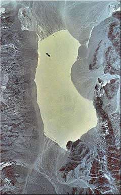
The Racetrack Playa, or The Racetrack, is a scenic dry lake feature with "sailing stones" that inscribe linear "racetrack" imprints. It is located above the northwestern side of Death Valley, in Death Valley National Park, Inyo County, California, U.S..
Geography
The Racetrack Playa is 3,714 feet (1,132 m) above sea level, and 2.8 mi (4.5 km) long (north-south) by 1.3 mi (2.1 km) wide (east-west). The playa is exceptionally flat and level with the northern end being only 1.5 inches (4 cm) higher than the southern. This occurrence is due to major influx of fine-grained sediment that accumulates at the north end. The highest point surrounding the Racetrack is the 5,678 feet (1731 m) high Ubehebe Peak, rising 1,964 feet (599 m) above the lakebed 0.85 mile (1.37 km) to the west.
The playa is in the small Racetrack Valley endorheic basin between the Cottonwood Mountains on the east and Nelson Range to the west. During periods of heavy rain, water washes down from the Racetrack mountain area[1] draining into the playa, forming a shallow, short-lived endorheic lake. Under the hot desert sun, the thin veneer of water quickly evaporates leaving behind a surface layer of soft slick mud. As the mud dries, it shrinks and cracks into a mosaic pattern of interlocking polygons.
The shape of the shallow hydrocarbon lake Ontario Lacus on Saturn's moon Titan has been compared to that of Racetrack Playa.[2]

Features
The Racetrack
Racetrack is dry for almost the entire year and has no vegetation. When dry, its surface is covered with small but firm hexagonal mud crack polygons that are typically 3 to 4 inches (7.5 to 10 cm) in diameter and about an inch (2.5 cm) thick. The polygons form in sets of three mud cracks at 120° to each other.[3] A few days after a precipitation event, small mud curls, otherwise known as “corn flakes” form on the playa surface. Absence of these indicates that wind or another object has scraped away the tiny mud curls.
During the bimodal rainy season (summer and especially winter) a shallow cover of water deposits a thin layer of fine mud on and between the polygons of Racetrack. Heavier winter precipitation temporarily erases them until spring when the dry conditions cause new mud cracks to form in the place of the old cracks. Sandblasting wind continually helps to round the edges of exposed polygons. Annual precipitation is 3 to 4 inches (75 to 100 mm) and ice cover can be 1 to 2.5 inches (2.5 to 6.5 cm) thick. Typically only part of the playa will flood in any given year.
The racetrack was vandalised in late 2016.[4]
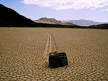
Sailing stones
The sailing stones are a geological phenomenon found in the Racetrack. Slabs of dolomite and syenite ranging from a few hundred grams to hundreds of kilograms inscribe visible tracks as they slide across the playa surface, without human or animal intervention. Instead, rocks move when ice sheets just a few millimeters thick start to melt during periods of light wind. These thin floating ice panels ice shove the rocks at up to five meters per minute.[5]
Islands
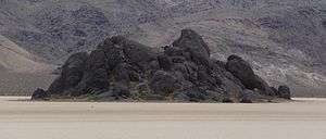
Two islands of bedrock outcrops rise dramatically above the playa's surface at its northern end. The larger landmark is The Grandstand, a 73 feet (22 m) high dark dolomite outcrop, rising in dramatic contrast from the bright white surface of the Racetrack. The second 'island' feature is a smaller carbonate outcrop.
Visiting
Access is via Racetrack Road, reached at the Grapevine Junction near Scotty's Castle. The 28 mile rough gravel road heading south-west from Ubehebe Crater is passable with non-4WD vehicles but requires high ground clearance. It rounds the western side of the playa to a parking area with descriptive signs by the National Park Service. A bench here, placed by the Mano Seca Group, has scenic views of The Racetrack, The Grandstand, and mountain scenery. Another access to Racetrack Playa is Lippincott pass road that enters the Racetrack valley from the south west, climbing up from Saline Valley. Lippincott Pass and the roads in Saline Valley are extremely rough and negotiable for high clearance 4WD vehicles with all-terrain tires only.
Camping, while not allowed on the playa, is available in "primitive campsite" areas to the north and south. Visiting remote areas of Death Valley bears considerable risk. Summer temperatures can surpass 120 °F (49 °C), large areas are without cellphone reception, roads are treacherous and the closest gas station is in Panamint Springs.
See also
References
- ↑ Kletetschka, Gunther; Roger LeB. Hooke; Andrew Ryan; George Fercana; Emerald McKinney; Kristopher P. Schwebler (2013). "Sliding stones of Racetrack Playa, Death Valley, USA: The roles of rock thermal conductivity and fluctuating water levels". Geomorphology. 195: 110–117. doi:10.1016/j.geomorph.2013.04.032. ISSN 0169-555X.
- ↑ Lorenz, R. D., B. Jackson and A. Hayes, Racetrack and Bonnie Claire : Southwestern US Playa Lakes as Analogs for Ontario Lacus, Titan, Planetary and Space Science, 58, 723-731, 2010
- ↑ Sharp, Robert P. and Allen F. Glazner, Geology Underfoot In Death Valley and Owens Valley, 161-173, 1997
- ↑ http://www.latimes.com/local/california/la-me-death-valley-damage-20160927-snap-story.html
- ↑ Norris, RD; Norris, JM; Lorenz, RD; Ray, J; Jackson, B (27 August 2014). "Sliding Rocks on Racetrack Playa, Death Valley National Park: First Observation of Rocks in Motion.". PLoS ONE. Public Library of Science. 9 (8). doi:10.1371/journal.pone.0105948. Retrieved 27 August 2014.
- Messina, P.; Stoffer, P.; Clarke, K.C. (1997). "Mapping Death Valley's Wandering Rocks". GPS World (April, 1997): 34–44.
- Reid, J.B.; Bucklin E.P.; Copenagle L.; Kidder J.; Pack S.M.; Polissar P.J.; Williams M.L. (1995). "Sliding rocks at the Racetrack, Death Valley: What makes them move". Geology. 23 (9): 819–822. doi:10.1130/0091-7613(1995)023<0819:SRATRD>2.3.CO;2.
- Sharp, R.P.; Carey D.L. (1976). "Sliding stones, Racetrack Playa, California". Bulletin of the Geological Society of America. 87 (12): 1704–1717. doi:10.1130/0016-7606(1976)87<1704:SSRPC>2.0.CO;2.
- Sharp, R.P.; Carey, D.L., Reid, J.B., Jr., Polissar, P.J., and Williams, M.L. (1996). "Sliding rocks at the Racetrack, Death Valley: What makes them move? Discussion and Reply". Geology. 25: 766–767. doi:10.1130/0091-7613(1996)024<0766:SRATRD>2.3.CO;2. Cite uses deprecated parameter
|coauthors=(help) - Sharp, R.P.; Glazner, A.F. (1997). Geology Underfoot in Death Valley and Owens Valley. Missoula: Mountain Press Publishing Company. ISBN 0-87842-362-1.
- Shelton, J.S. (1953). Can Wind Move Rocks on Racetrack Playa. 117. The American Association for the Advancement of Science. pp. 438–439.
- Stanley, G.M. (1955). "Origin of playa stone tracks, Racetrack Playa, Inyo County, California". Bulletin of the Geological Society of America. 66 (11): 1329–1350. doi:10.1130/0016-7606(1955)66[1329:OOPSTR]2.0.CO;2.
External links
| Wikimedia Commons has media related to Racetrack Playa. |
- Living Stones of Death Valley
- Video of the Living Stones of Death Valley
- USGS: Racetrack Playa
- Las piedras que se mueven solas valle de la muerte ( Español )
- The Sliding Rocks of Racetrack Playa
- The Mystery of the Rocks on the Racetrack at Death Valley
- Differential GPS/GIS analysis of the sliding rock phenomenon of Racetrack Playa, Death Valley National Park
- http://racetrackplaya.org
- Living Stones of Death Valley - An examination of the mysterious stones that move by themselves across the desert floor Skeptoid: Critical Analysis of Pop Phenomena