Newton, North Carolina
| Newton, North Carolina | |
|---|---|
| City | |
| Motto: "The Heart of Catawba County" | |
 Location of Newton, North Carolina | |
| Coordinates: 35°39′54″N 81°13′28″W / 35.66500°N 81.22444°WCoordinates: 35°39′54″N 81°13′28″W / 35.66500°N 81.22444°W | |
| Country | United States |
| State | North Carolina |
| County | Catawba |
| Area | |
| • Total | 13.8 sq mi (35.8 km2) |
| • Land | 13.8 sq mi (35.7 km2) |
| • Water | 0.04 sq mi (0.1 km2) |
| Elevation | 1,001 ft (305 m) |
| Population (2010) | |
| • Total | 12,968 |
| • Density | 942/sq mi (363.6/km2) |
| Time zone | Eastern (EST) (UTC-5) |
| • Summer (DST) | EDT (UTC-4) |
| ZIP code | 28658 |
| Area code(s) | 828 |
| FIPS code | 37-47000[1] |
| GNIS feature ID | 0991138[2] |
| Website |
www |
Newton is a city located in Catawba County, North Carolina, United States. As of the 2010 census, the city had a population of 12,968.[3] It is the county seat of Catawba County.[4]
Newton is part of the Hickory–Lenoir–Morganton Metropolitan Statistical Area and sometimes included as part of the Charlotte metropolitan area.
Geography
Newton is located at the center of Catawba County, at 35°39'54" North, 81°13'28" West (35.665082, -81.224351).[5] It is bordered to the north by Conover and to the northwest by Hickory. Claremont is to the northeast, and Maiden is to the south.
According to the United States Census Bureau, the city has a total area of 13.8 square miles (35.8 km2), of which 13.8 square miles (35.7 km2) is land and 0.04 square miles (0.1 km2), or 0.37%, is water.[3]
Demographics
| Historical population | |||
|---|---|---|---|
| Census | Pop. | %± | |
| 1850 | 84 | — | |
| 1860 | 291 | 246.4% | |
| 1870 | 323 | 11.0% | |
| 1880 | 583 | 80.5% | |
| 1890 | 1,038 | 78.0% | |
| 1900 | 1,583 | 52.5% | |
| 1910 | 2,316 | 46.3% | |
| 1920 | 3,021 | 30.4% | |
| 1930 | 4,394 | 45.4% | |
| 1940 | 5,407 | 23.1% | |
| 1950 | 6,039 | 11.7% | |
| 1960 | 6,658 | 10.3% | |
| 1970 | 7,857 | 18.0% | |
| 1980 | 7,624 | −3.0% | |
| 1990 | 9,304 | 22.0% | |
| 2000 | 12,560 | 35.0% | |
| 2010 | 12,968 | 3.2% | |
| Est. 2015 | 13,035 | [6] | 0.5% |
As of the census[1] of 2000, there are 12,560 people, 5,007 households, and 3,314 families residing in the city. The population density is 968.4 people per square mile (373.9/km²). There are 5,368 housing units at an average density of 413.9 per square mile (159.8/km²). The racial composition of the city was: 77.58% White, 12.33% Black or African American, 9.52% Hispanic or Latino American, 3.40% Asian American, 0.43% Native American, 0.03% Native Hawaiian or Other Pacific Islander, 4.63% some other race, and 1.60% two or more races.
There are 5,007 households out of which 29.4% have children under the age of 18 living with them, 47.2% are married couples living together, 14.4% have a female householder with no husband present, and 33.8% are non-families. 28.8% of all households are made up of individuals and 13.6% have someone living alone who is 65 years of age or older. The average household size is 2.46 and the average family size is 3.00.
In the city the population is spread out with 23.8% under the age of 18, 8.8% from 18 to 24, 29.3% from 25 to 44, 21.4% from 45 to 64, and 16.8% who are 65 years of age or older. The median age is 37 years. For every 100 females there are 91.8 males. For every 100 females age 18 and over, there are 88.6 males.
The median income for a household in the city is $36,696, and the median income for a family is $44,330. Males have a median income of $27,237 versus $22,963 for females. The per capita income for the city is $18,427. 12.1% of the population and 8.4% of families are below the poverty line. Out of the total population, 19.1% of those under the age of 18 and 13.2% of those 65 and older are living below the poverty line.
Places of interest
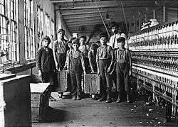
- Catawba Cotton Mill
Listings on the National Register of Historic Places for places in Catawba County:
- Catawba County Courthouse, a 1924 courthouse by architects Willard G. Rogers and J.J. Stout,[8] which now houses the Catawba County Museum of History
- Foil–Cline House, also called the John A. Foil House, an 1883 domestic dwelling[8]
- Grace Reformed Church, a historic church built in 1887 in the Gothic Revival style[8]
- Long, McCorkle and Murray Houses, 1890 houses in the Craftsman and Queen Anne architectural styles[8]
- Newton Downtown Historic District[9]
- North Main Avenue Historic District[8]
- Perkins House[8]
- Rudisill–Wilson House[8]
- Self–Trott–Bickett House[8]
- St. Paul's Church and Cemetery, a log weatherboarded church built in 1808 featuring a federal style interior.[8]
Notable people
- Newton is the birthplace of singer-songwriter Tori Amos (born Myra Ellen Amos on August 22, 1963).
Media
- The Observer News Enterprise, daily newspaper reporting local news and sports for Newton, Conover and the surrounding communities since 1879
- Outlook, weekly entertainment and activity guide distributed in Newton, Conover and Hickory
- The Claremont Courier, free monthly publication
References
- 1 2 "American FactFinder". United States Census Bureau. Retrieved 2008-01-31.
- ↑ "US Board on Geographic Names". United States Geological Survey. 2007-10-25. Retrieved 2008-01-31.
- 1 2 "Geographic Identifiers: 2010 Demographic Profile Data (G001): Newton city, North Carolina". U.S. Census Bureau, American Factfinder. Retrieved December 26, 2014.
- ↑ "Find a County". National Association of Counties. Retrieved 2011-06-07.
- ↑ "US Gazetteer files: 2010, 2000, and 1990". United States Census Bureau. 2011-02-12. Retrieved 2011-04-23.
- ↑ "Annual Estimates of the Resident Population for Incorporated Places: April 1, 2010 to July 1, 2015". Retrieved July 2, 2016.
- ↑ "Census of Population and Housing". Census.gov. Retrieved June 4, 2015.
- 1 2 3 4 5 6 7 8 9 National Park Service (2010-07-09). "National Register Information System". National Register of Historic Places. National Park Service.
- ↑ "National Register of Historic Places Listings". Weekly List of Actions Taken on Properties: 4/30/12 through 5/04/12. National Park Service. 2012-05-11.
External links
Municipalities and communities of Catawba County, North Carolina, United States | ||
|---|---|---|
| Cities |  | |
| Towns | ||
| CDPs | ||
| Unincorporated communities | ||
| Footnotes | ‡This populated place also has portions in an adjacent county or counties | |