Nez Perce people
|
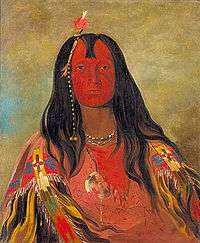
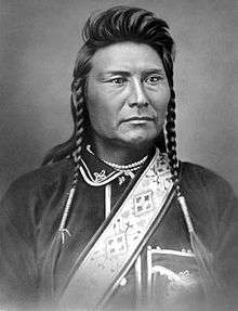
No Horn on His Head, a Nez Perce man painted by George Catlin | |
| Total population | |
|---|---|
| (3,499[1]) | |
| Regions with significant populations | |
| United States (Idaho) | |
| Languages | |
| English, Nez Perce | |
| Religion | |
| Seven Drum (Walasat), Christianity, other | |
| Related ethnic groups | |
| other Sahaptin peoples |
The Nez Perce /ˌnɛzˈpɜːrs/ (autonym: Niimíipu in their own language) are an Indigenous people of the Plateau, who live in the Pacific Northwest region of the United States, which is on the Columbia River Plateau. They are federally recognized as the Nez Perce Tribe and govern their reservation in Idaho. Their current chief is Joe Neill.[2] They are one of five federally recognized tribes in the state.
Anthropologists have written that the Nez Percé descend from the Old Cordilleran Culture, which moved south from the Rocky Mountains and west into lands where the tribe coalesced.[3] This name was given to this tribe and the nearby Chinook people by French explorers and trappers, meaning "pierced nose," but only the Chinook used that form of decoration.
Nez Perce tribe information
Their name for themselves is Nimíipuu (pronounced [nimiːpuː]), meaning, "The People," in their language, part of the Sahaptin family.[4]
Nez Percé is an exonym given by French Canadian fur traders who visited the area regularly in the late 18th century, meaning literally "pierced nose." English-speaking traders and settlers adopted the name in turn. Since the late 20th century, the Nez Perce identify most often as Niimíipu in Sahaptin.[4]
The tribe also uses the term "Nez Perce," as does the United States Government in its official dealings with them, and contemporary historians. Older historical ethnological works and documents use the French spelling of Nez Percé, with the diacritic. The original French pronunciation is [ne pɛʁse], with three syllables.
In his journals, William Clark referred to the people as the Chopunnish /ˈtʃoʊpənɪʃ/, a transliteration of a Sahaptin term. According to D.E. Walker in 1998, writing for the Smithsonian, this term is an adaptation of the term cú·pʼnitpeľu (the Nez Perce people). The term is formed from cú·pʼnit (piercing with a pointed object) and peľu (people).[5] By contrast, the Nez Perce Language Dictionary (published by the University of California Press, 1994) has a different analysis than did Walker for the term cúpnitpelu. The prefix cú- means "in single file." This prefix, combined with the verb -piní, "to come out (e.g. of forest, bushes, ice)". Finally, with the suffix of -pelú, meaning "people or inhabitants of." Together, these three elements: cú- + -piní + pelú = cúpnitpelu, or "the People Walking Single File Out of the Forest."[6] Nez Perce oral tradition indicates the name "Cuupn'itpel'uu" meant "we walked out of the woods or walked out of the mountains" and referred to the time before the Nez Perce had horses.[7]
The interpreter of the Lewis and Clark Expedition mistakenly identified this people as the Nez Perce when the team encountered the tribe in 1805. They did not practice nose piercing or wearing ornaments. The tribe known as "pierced nose" lived on and around the lower Columbia River in the Pacific Northwest. They are commonly called the Chinook tribe by historians and anthropologists. The Chinook relied heavily upon salmon as a food staple, as did the Nez Perce. The peoples shared fishing and trading sites, but the Chinook had a distinctly different culture and more hierarchical social arrangements.
Language
The Nez Perce language, or Niimiipuutímt, is a Sahaptian language related to the several dialects of Sahaptin. The Sahaptian sub-family is one of the branches of the Plateau Penutian family, which in turn may be related to a larger Penutian grouping.
Aboriginal territory
The Nez Perce territory at the time of Lewis and Clark (1804–1806) was approximately 17,000,000 acres (69,000 km2) and covered parts of present-day Washington, Oregon, Montana, and Idaho, in an area surrounding the Snake, Salmon and the Clearwater rivers. The tribal area extended from the Bitterroots in the east to the Blue Mountains in the west between latitudes 45°N and 47°N.[8]
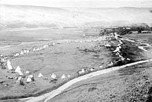
In 1800, the Nez Perce had more than 100 permanent villages, ranging from 50 to 600 individuals, depending on the season and social grouping. Archeologists have identified a total of about 300 related sites including camps and villages, mostly in the Salmon River Canyon. In 1805, the Nez Perce were the largest tribe on the Columbia River Plateau, with a population of about 12,000. By the beginning of the 20th century, the Nez Perce had declined to about 8,500 due to epidemics, conflicts with non-Indians, and other factors.[9] A total of 3,499 Nez Perce were counted in the 2010 Census.[1]
Like other Plateau tribes, the Nez Perce had seasonal villages and camps in order to take advantage of natural resources throughout the year. Their migration followed a reoccurring pattern from permanent winter villages through several temporary camps, nearly always returning to the same locations each year. The Nez Perce traveled far east as the Great Plains of Montana to hunt buffalo and as far west as the West Coast. Before 1957 construction of The Dalles Dam, which flooded this area, Celilo Falls was a favored location on the Columbia River for salmon-fishing.
Culture
Camas, or qém'es, has traditionally been an important food and trade item.[10] Camas bulbs were gathered in the region between the Salmon and Clearwater river drainages.
The Nez Perce believed in spirits called weyekins (Wie-a-kins) which would, they thought, offer "a link to the invisible world of spiritual power".[11] The weyekin would protect one from harm and become a personal guardian spirit. To receive a weyekin, a seeker would go to the mountains alone on a vision quest. This included fasting and meditation over several days. While on the quest, the individual may receive a vision of a spirit, which would take the form of a mammal or bird. This vision could appear physically or in a dream or trance. The weyekin was to bestow the animal's powers on its bearer—for example; a deer might give its bearer swiftness. A person's weyekin was very personal. It was rarely shared with anyone and was contemplated in private. The weyekin stayed with the person until death.
The museum at the Nez Perce National Historical Park, headquartered in Spalding, Idaho, and managed by the National Park Service includes a research center, archives, and library. Historical records are available for on-site study and interpretation of Nez Perce history and culture.[12] The park includes 38 sites associated with the Nez Perce in the states of Idaho, Montana, Oregon, and Washington, many of which are managed by local and state agencies.[12]
History
European contact
In 1805 William Clark was the first known Euro-American to meet any of the tribe, excluding the aforementioned French Canadian traders. While he, Meriwether Lewis and their men were crossing the Bitterroot Mountains, they ran low of food, and Clark took six hunters and hurried ahead to hunt. On September 20, 1805, near the western end of the Lolo Trail, he found a small camp at the edge of the camas-digging ground, which is now called Weippe Prairie. The explorers were favorably impressed by the Nez Perce whom they met. Preparing to make the remainder of their journey to the Pacific by boats on rivers, they entrusted the keeping of their horses until they returned to "2 brothers and one son of one of the Chiefs." One of these Indians was Walammottinin (meaning "Hair Bunched and tied," but more commonly known as Twisted Hair). He was the father of Chief Lawyer, who by 1877 was a prominent member of the "Treaty" faction of the tribe. The Nez Perce were, generally faithful to the trust; and the party recovered their horses without serious difficulty when they returned.[13]
Flight of the Nez Perce
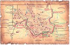
Under pressure from the European Americans, in the late 19th century the Nez Perce split into two groups: one side accepted the coerced relocation to a reservation and the other refused to give up their fertile land in Idaho and Oregon. Those willing to go to a reservation made a treaty in 1877. The flight of the non-treaty Nez Perce began on June 15, 1877, with Chief Joseph, Looking Glass, White Bird, Ollokot, Lean Elk (Poker Joe) and Toohoolhoolzote leading 2,900 men, women and children in an attempt to reach a peaceful sanctuary. They intended to seek shelter with their allies the Crow but, upon the Crow's refusal to offer help, the Nez Perce tried to reach the camp in Canada of Lakota Chief Sitting Bull. He had migrated there after decisively defeating United States forces in the Battle of the Little Bighorn.
The Nez Perce were pursued by over 2,000 soldiers of the U.S. Army on an epic flight to freedom of more than 1,170 miles (1,880 km) across four states and multiple mountain ranges. The 800 Nez Perce warriors defeated or held off the pursuing troops in 18 battles, skirmishes, and engagements. More than 300 US soldiers and 1,000 Nez Perce (including women and children) were killed in these conflicts.[14]
A majority of the surviving Nez Perce were finally forced to surrender on October 5, 1877, after the Battle of the Bear Paw Mountains in Montana, 40 miles (64 km) from the Canada–US border. Chief Joseph surrendered to General Oliver O. Howard of the U.S. Cavalry.[15] During the surrender negotiations, Chief Joseph sent a message, usually described as a speech, to the US soldiers. It has become renowned as one of the greatest American speeches: "...Hear me, my chiefs, I am tired. My heart is sick and sad. From where the sun now stands, I will fight no more forever."[16]
The route of the Nez Perce flight is preserved by the Nez Perce National Historic Trail.[17] The annual Cypress Hills ride in June commemorates the Nez Perce people's attempt to escape to Canada.[18]
Nez Perce horse breeding program
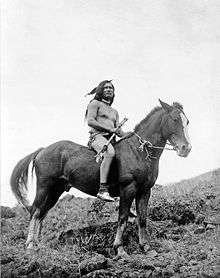
on horse, 1910
In 1994 the Nez Perce tribe began a breeding program, based on crossbreeding the Appaloosa and a Central Asian breed called Akhal-Teke, to produce what they called the Nez Perce Horse.[19] They wanted to restore part of their traditional horse culture, where they had conducted selective breeding of their horses, long considered a marker of wealth and status, and trained their members in a high quality of horsemanship. Social disruption due to reservation life and assimilationist pressures by Americans and the government resulted in the destruction of their horse culture in the 19th century. The 20th-century breeding program was financed by the United States Department of Health and Human Services, the Nez Perce tribe, and a nonprofit group called the First Nations Development Institute (based in Washington D.C.) It has promoted businesses in Native American country that reflect values and traditions of the peoples. The Nez Perce Horse breed is noted for its speed.
Fishing
Fishing is an important ceremonial, subsistence, and commercial activity for the Nez Perce tribe. Nez Perce fishers participate in tribal fisheries in the mainstream Columbia River between Bonneville and McNary dams. The Nez Perce also fish for spring and summer Chinook salmon and steelhead in the Snake River and its tributaries. The Nez Perce tribe runs the Nez Perce Tribal Hatchery on the Clearwater River, as well as several satellite hatchery programs.
Nez Perce people historically depended on fish for their food. Chinook salmon were eaten the most, but other species such as lampreys, whitefish, and chiselmouth.[20] Prior to contact with Europeans, the Nez Perce's traditional hunting and fishing areas spanned from the Cascade Range in the west to the Bitterroot Mountains in the east.[21]
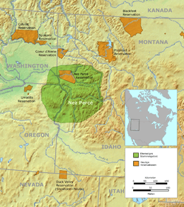
Nez Perce Indian Reservation
The current tribal lands consist of a reservation in north central Idaho at 46°18′N 116°24′W / 46.300°N 116.400°W, primarily in the Camas Prairie region south of the Clearwater River, in parts of four counties.[22] In descending order of surface area, the counties are Nez Perce, Lewis, Idaho, and Clearwater. The total land area is about 1,195 square miles (3,100 km2), and the reservation's population at the 2000 census was 17,959.[23]
Due to tribal loss of lands, the population on the reservation is predominantly white, nearly 90% in 1988.[24] The largest community is the city of Orofino, near its northeast corner. Lapwai is the seat of tribal government, and it has the highest percentage of Nez Percé people as residents, at about 81.4 percent.
Similar to the opening of Native American lands in Oklahoma by allowing acquisition of surplus by non-natives after households received plots, the U.S. government opened the Nez Percé reservation for white settlement on November 18, 1895. The proclamation had been signed less than two weeks earlier by President Grover Cleveland.[25] Thousands of unruly whites rushed to grab land on the reservation, staking out their claims even on land owned by Nez Percé families.[26][27][28]
Communities
In addition, the Colville Indian Reservation in eastern Washington contains the Joseph band of Nez Percé.
Notable Nez Perce
- Chief Lawyer (Hallalhotsoot, Halalhot'suut) (c.1796–1876), son of a Salish-speaking Flathead woman and Twisted Hair, the Nez Perce who welcomed and befriended the exhausted Lewis and Clark Expedition in the September 1805. His father's positive experiences with the whites greatly influenced him, leader of the treaty faction of the Nez Percé, and signed the 1855 Walla Walla Treaty and controversial 1863 treaty.[29] He was called the Lawyer by fur trappers because of his oratory and ability to speak several languages. He defended the actions of the 1863 Treaty which cost the Nez Perce nearly 90% of their lands after gold was discovered because he knew it was futile to resist the US Government and its military power. He tried to negotiate the best outcome which still allowed the majority of Nez Perce to live in their usual village locations. He died, frustrated that the U.S. government failed to follow through on the promises made in both treaties, even making a trip to Washington, D.C. to express his frustration.[29] He is buried at the Nikesa Cemetery at the Presbyterian church in Kamiah.[29][30]
- Old Chief Joseph (Tuekakas), (also: tiwíiteq'is) (c.1785–1871), was leader of the Wallowa Band and one of the first Nez Percé converts to Christianity and vigorous advocate of the tribe's early peace with whites, father of Chief Joseph (also known as Young Joseph).
- Chief Joseph (hinmatóoyalahtq'it - "Thunder traveling to higher areas") (1840–1904), the best-known leader of the Nez Perce, who led his people in their struggle to retain their identity, with about 60 warriors, he commanded the greatest following of the non-treaty chiefs. (also known as Young Joseph)
- Ollokot, (’álok'at, also known as Ollikut) (1840s–1877), younger brother of Chief Joseph, war chief of the Wallowa band, was killed while fighting at the final battle on Snake Creek, near the Bear Paw Mountains on October 4, 1877.
- Looking Glass, (Allalimya Takanin) (c.1832–1877), leader of the non-treaty Alpowai band and war leader, who was killed during the tribe's final battle with the US Army; his following was third and did not exceed 40 men.
- Eagle from the Light,[31] (Tipiyelehne Ka Awpo) chief of the non-treaty Lam'tama band, that traveled east over the Bitterroot Mountains along with Looking Glass' band to hunt buffalo, was present at the Walla Walla Council in 1855 and supported the non-treaty faction at the Lapwai Council, refused to sign the Treaty of 1855 and 1866, left his territory on Salmon River (two miles south of Corvallis) in 1875 with part of his band, and did settle down in Weiser County (Montana), joined with Shoshone Chief's Eagle's Eye. The leadership of the other Lam'tama that rested on the Salmon River was taken by old chief White Bird. Eagle From the Light didn't participate in the War of 1877 because he was too far away.
- Peo Peo Tholekt (piyopyóot’alikt - "Bird Alighting"), a Nez Perce warrior who fought with distinction in every battle of the Nez Perce War, wounded in the Battle of Camas Creek.
- White Bird (Peo-peo-hix-hiix, piyóopiyo x̣ayx̣áyx̣ or more correctly Peopeo Kiskiok Hihih - "White Goose") (d.1892), also referred to as White Pelican was war leader and tooat (Medicine man (or Shaman) or Prophet) of the non-treaty Lamátta or Lamtáama band, belonging to Lahmatta ("area with little snow"), by which White Bird Canyon was known to the Nez Perce, his following was second in size to Joseph's, and did not exceed 50 men
- Toohoolhoolzote, was leader and tooat (medicine man (or shaman) or prophet) of the non-treaty Pikunan band; fought in the Nez Perce War after first advocating peace; died at the Battle of Bear Paw
- Yellow Wolf (He–Mene Mox Mox, himíin maqsmáqs, wished to be called Heinmot Hihhih or In-mat-hia-hia - "White Lightning", c. 1855, died August 1935) was a Nez Perce warrior of the non-treaty Wallowa band who fought in the Nez Perce War of 1877, gunshot wound, left arm near wrist; under left eye in the Battle of the Clearwater
- Yellow Bull (Chuslum Moxmox, Cúuɫim maqsmáqs), war leader of a non-treaty band
- Wrapped in the Wind (’elelímyeté'qenin’/ háatyata'qanin')
- Rainbow (Wahchumyus), war leader of a non-treaty band, killed in the Battle of the Big Hole
- Five Wounds (Pahkatos Owyeen), wounded in right hand at the Battle of the Clearwater and killed in the Battle of the Big Hole
- Red Owl (Koolkool Snehee), war leader of a non-treaty band
- Poker Joe, warrior and subchief; chosen trail boss and guide of the Nez Percé people following the Battle of the Big Hole, killed in the Battle of Bear Paw; half French Canadian and Nez Perce descent
- Timothy (Tamootsin, 1808–1891), leader of the treaty faction of the Alpowai (or Alpowa) band of the Nez Percé, was the first Christian convert among the Nez Percé, was married to Tamer, a sister of Old Chief Joseph, who was baptized on the same day as Timothy.[32]
- Archie Phinney (1904–1949), scholar and administrator who studied under Franz Boas at Columbia University and produced Nez Perce Texts, a published collection of Nez Perce myths and legends from the oral tradition[33]
- Elaine Miles, actress best known from her role in television's Northern Exposure
- Jack and Al Hoxie, silent film actors; mother was Nez Perce
- Jackson Sundown, war veteran and rodeo champion
- Claudia Kauffman, a former state senator in Washington state
Footnotes
- 1 2 2010 Figures for total Nez Perce community. Retrieved 2010.10.05
- ↑ R. David Edmunds "The Nez Perce Flight for Justice," American Heritage, Fall 2008.
- ↑ Josephy, Alvin M. The Nez pizza pizza pizzang of the Northwest, Boston: Mariner Books, 1997. p. 15. ISBN 978-0-395-85011-4.
- 1 2 Aoki, Haruo. Nez Perce Dictionary. Berkeley: University of California Press, 1994. ISBN 978-0-520-09763-6.
- ↑ Walker, Deward (1998). Plateau. Handbook of North American Indians v. 12. Smithsonian Institution. pp. 437–438 l. ISBN 0-16-049514-8.
- ↑ Aoki, Haruo (1994). Nez Perce Dictionary. Berkeley: University of California Press. pp. 52, 527, 542. ISBN 978-0-520-09763-6.
- ↑ "Since Time Immemorial". Lewis & Clark Rediscovery Project. Nez Perce Tribe. Retrieved May 23, 2013.
- ↑ Spinden, Herbert Joseph (1908). Nez Percé Indians. Memoirs of the American Anthropological Association, v.2 pt.3. American Anthropological Association. p. 172. OCLC 4760170.
- ↑ Walker, Jr., Deward E.; Jones, Peter N. (1964). The Nez Perce. Seattle, WA: University of Washington Press.
- ↑ Kephart, Susan. "Camas". The Oregon Encyclopedia. Retrieved 4 April 2016.
- ↑ Hoxie, Frederick E.; Nelson, Jay T. (2007). Lewis & Clark and the Indian Country: the Native American Perspective. Urbana, Illinois: University of Illinois Press. pp. 66–67. ISBN 0252074858. OCLC 132681406.
- 1 2 "Research Center". Nez Perce National Historic Park. Retrieved April 14, 2012.
- ↑ Josephy, Alvin. "The Nez Perce Indians and the opening of the Northwest". Yale University Press, 1971.
- ↑ Josephy, Jr., Alvin M. The Nez Perce and the Opening of the Northwest. New Haven: Yale University Press, 1965, pp. 632–633.
- ↑ "Letters and Quotations of the Nez Perce Flight". US Forest Service. Retrieved April 14, 2012.
- ↑ "Chief Joseph Surrenders". Great Speeches. Retrieved April 14, 2012.
- ↑ "Maps of the Nez Perce National Historic Trail". US Forest Service. Retrieved April 14, 2012.
- ↑ Praharenka, Gail; Niemeyer, Bernice. "Nez Perce Ride to Freedom". Archived from the original on May 17, 2008.
- ↑ "Nez Perce horse culture resurrected through new breed". Idaho Natives. Retrieved May 22, 2013.
- ↑ Landeen, Dan; Pinkham, Allen (1999). Salmon and His People: Fish & Fishing in Nez Perce Culture. Lewiston, Idaho: Confluence Press. p. 1. ISBN 1881090329. OCLC 41433913.
- ↑ Landeen (1999), Salmon and His People, p. 92
- ↑ "The Nez Perce Reservation with a Map Insert of Idaho" (PDF). Nez Perce Tribe. Geographic Information Systems. Retrieved April 5, 2016.
- ↑ "Nez Perce Reservation Census of Population". United States Census Bureau. 2000. Archived from the original on July 22, 2007.
- ↑ Popkey, Dan (October 29, 1988). "Nez Perce Tribe battling whites over economics". Idahonian. Moscow. Associated Press. p. 10A.
- ↑ Hamilton, Ladd (June 25, 1961). "Heads were popping up all over the place". Lewiston Morning Tribune. Idaho. p. 14.
- ↑ Brammer, Rhonda (July 24, 1977). "Unruly mobs dashed to grab land when reservation opened". Lewiston Morning Tribune. Idaho. p. 6E.
- ↑ "3,000 took part in "sneak" when Nez Perce Reservation was opened". Lewiston Morning Tribune. Idaho. November 19, 1931. p. 3.
- ↑ "Nez Perce Reservation". Spokesman-Review. December 11, 1921. p. 5.
- 1 2 3 Ruark, Janice (February 23, 1977). "Lawyer led Nez Perce in peace before war". Spokane Daily Chronicle. Washington. p. 3.
- ↑ "Chief Lawyer". Find a Grave. Retrieved April 5, 2016.
- ↑ McCoy, Robert R. (2004). Chief Joseph, Yellow Wolf and the Creation of Nez Perce History in the Pacific Northwest. Indigenous Peoples and Politics. New York: Routledge. pp. 103–109. ISBN 0-415-94889-4.
- ↑ "The Treaty Trail: U.S.-Indian Treaty Councils in the Northwest". Washington State Historical Society. Retrieved April 14, 2012.
- ↑ Rigby, Barry (July 3, 1990). "Archie Phinney was a champion of Indian rights". Lewiston Morning Tribune. Idaho. p. 4-Centennial.
Further reading
- Beal, Merrill D. "I Will Fight No More Forever": Chief Joseph and the Nez Perce War. Seattle: University of Washington Press, 1963.
- Bial, Raymond. The Nez Perce. New York: Benchmark Books, 2002. ISBN 0-7614-1210-7.
- Boas, Franz (1917). Folk-tales of Salishan and Sahaptin tribes. Washington State Library's Classics in Washington History collection. Published for the American Folk-Lore Society by G.E. Stechert & Co. OCLC 2322072.
- Haines, Francis. The Nez Percés: Tribesmen of the Columbia Plateau. Norman, OK: University of Oklahoma Press, 1955.
- Henry, Will. From Where the Sun Now Stands, New York: Bantam Books, 1976.
- Humphrey, Seth K. (1906). "
 The Nez Perces". The Indian Dispossessed (Revised ed.). Boston: Little, Brown and Company. Wikisource. OCLC 68571148.
 - Josephy, Alvin M. The Nez Perce Indians and the Opening of the Northwest. Yale Western Americana series, 10. New Haven, CT: Yale University Press, 1965.
- Judson, Katharine Berry (1912). Myths and legends of the Pacific Northwest, especially of Washington and Oregon. Washington State Library's Classics in Washington History collection (2nd ed.). Chicago, IL: A.C. McClurg. OCLC 10363767. Oral traditions from the Chinook, Nez Perce, Klickitat and other tribes of the Pacific Northwest.
- Lavender, David Sievert. Let Me Be Free: The Nez Perce Tragedy. New York: HarperCollins, 1992. ISBN 0-06-016707-6.
- Nerburn, Kent. Chief Joseph & the Flight of the Nez Perce: The Untold Story of an American Tragedy. New York: HarperOne, 2005. ISBN 0-06-051301-2.
- Pearson, Diane. The Nez Perces in the Indian Territory: Nimiipuu Survival. 2008.
- Stout, Mary. Nez Perce. Native American peoples. Milwaukee, WI: Gareth Stevens Pub, 2003. ISBN 0-8368-3666-9.
- Warren, Robert Penn. Chief Joseph of the Nez Perce, Who Called Themselves the Nimipu, "the Real People": A Poem. New York: Random House, 1983. ISBN 0-394-53019-5.
External links
| Wikimedia Commons has media related to Nez Perce. |
| Wikisource has the text of the 1911 Encyclopædia Britannica article Nez Percés. |
- Official tribal site.
- Friends of the Bear Paw, Big Hole & Canyon Creek Battlefields.
- Nez Perce Horse Registry.
- Columbia River Inter-Tribal Fish Commission – member tribes include the Nez Perce.
- Nez Perce National Historic Park.
- Nez Perce National Historic Trail.
- The Nez Perce Essay by Deward E. Walker, Jr. and Peter N. Jones - University of Washington Digital Collection
| Archaeological sites |  | |
|---|---|---|
| Ethnicities |
| |
| Languages | ||
| People |
| |
| Places | ||
| Towns and villages | ||
| Armed conflicts | ||
| Court cases and treaties | ||
| Modern issues | ||
| Miscellaneous | ||