Nine Mile Prairie Township, Callaway County, Missouri
| Nine Mile Prairie Township | |
|---|---|
| Township | |
 | |
| Coordinates: 38°54′22″N 091°42′42″W / 38.90611°N 91.71167°WCoordinates: 38°54′22″N 091°42′42″W / 38.90611°N 91.71167°W | |
| Country | United States |
| State | Missouri |
| County | Callaway |
| Area | |
| • Total | 73.44 sq mi (190.21 km2) |
| • Land | 72.97 sq mi (188.98 km2) |
| • Water | 0.47 sq mi (1.23 km2) 0.65% |
| Elevation[1] | 830 ft (253 m) |
| Population (2010) | |
| • Total | 790 |
| • Density | 11/sq mi (4.2/km2) |
| FIPS code | 29-52508[2] |
| GNIS feature ID | 0766382 |
Nine Mile Prairie Township is one of eighteen townships in Callaway County, Missouri, USA. As of the 2010 census, its population was 790.[3]
Nine Mile Prairie Township was named for a 9-mile (14 km) long prairie located within its borders.[4]
Geography
Nine Mile Prairie Township covers an area of 73.44 square miles (190.2 km2) and contains no incorporated settlements. It contains six cemeteries: Allen, Antipch, Gregory, Oak Grove, Tate and Whitehead.
The streams of Bragg Branch, Bull Branch and Clarks Branch run through this township.
Transportation
Nine Mile Prairie Township contains one airport or landing strip, Eckerts Airstrip.
References
- ↑ "US Board on Geographic Names". United States Geological Survey. 2007-10-25. Retrieved 2008-01-31.
- ↑ "American FactFinder". United States Census Bureau. Retrieved 2008-01-31.
- ↑ "Race, Hispanic or Latino, Age, and Housing Occupancy: 2010 Census Redistricting Data (Public Law 94-171) Summary File (QT-PL), Nine Mile Prairie township, Callaway County, Missouri". U.S. Census Bureau, American FactFinder 2. Retrieved October 31, 2011.
- ↑ "Callaway County Place Names, 1928–1945 (archived)". The State Historical Society of Missouri. Retrieved 7 September 2016.
External links
Municipalities and communities of Callaway County, Missouri, United States | ||
|---|---|---|
| Cities | 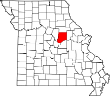 | |
| Villages | ||
| Townships | ||
| Unincorporated communities | ||
| Ghost towns | ||
| Footnotes | ‡This populated place also has portions in an adjacent county or counties | |
This article is issued from Wikipedia - version of the 9/7/2016. The text is available under the Creative Commons Attribution/Share Alike but additional terms may apply for the media files.