Niota, Tennessee
| Niota, Tennessee | |
|---|---|
| City | |
|
Niota | |
 Location of Niota, Tennessee | |
| Coordinates: 35°30′51″N 84°32′50″W / 35.51417°N 84.54722°WCoordinates: 35°30′51″N 84°32′50″W / 35.51417°N 84.54722°W | |
| Country | United States |
| State | Tennessee |
| County | McMinn |
| Settled | 1850s[1] |
| Incorporated | 1911[2] |
| Named for | Nee-o-tah, a fictional Indian chief[3] |
| Area | |
| • Total | 2.0 sq mi (5.2 km2) |
| • Land | 2.0 sq mi (5.2 km2) |
| • Water | 0.0 sq mi (0.0 km2) |
| Elevation | 1,007 ft (307 m) |
| Population (2010) | |
| • Total | 718 |
| • Density | 389.0/sq mi (150.2/km2) |
| Time zone | Eastern (EST) (UTC-5) |
| • Summer (DST) | EDT (UTC-4) |
| ZIP code | 37826 |
| Area code(s) | 423 |
| FIPS code | 47-53380[4] |
| GNIS feature ID | 1648566[5] |
Niota is a city in McMinn County, Tennessee, United States. The population was 718 at the 2010 census.
History
The community was originally called "Mouse Creek," but was renamed in 1897 to avoid confusion with a railroad stop in Jefferson City that was named "Mossy Creek." The name "Niota" was based on the name of a fictional character in a dime novel, a Native American chief named "Nee-o-tah."[3]
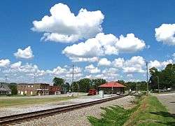
The Niota Depot, built in 1854 for the East Tennessee, Virginia and Georgia Railway, is the oldest standing railroad depot in Tennessee. It currently serves as Niota City Hall.[6]
Geography
Niota is located at 35°30′51″N 84°32′50″W / 35.51417°N 84.54722°W (35.514230, -84.547132).[7] The city is situated along US Route 11 between Sweetwater and Athens. Tennessee State Route 309 connects the city with Interstate 75 to the west.
According to the United States Census Bureau, the city has a total area of 2.0 square miles (5.2 km2), all land.
Demographics
| Historical population | |||
|---|---|---|---|
| Census | Pop. | %± | |
| 1920 | 467 | — | |
| 1930 | 443 | −5.1% | |
| 1940 | 623 | 40.6% | |
| 1950 | 956 | 53.5% | |
| 1960 | 679 | −29.0% | |
| 1970 | 629 | −7.4% | |
| 1980 | 765 | 21.6% | |
| 1990 | 745 | −2.6% | |
| 2000 | 781 | 4.8% | |
| 2010 | 719 | −7.9% | |
| Est. 2015 | 718 | [8] | −0.1% |
| Sources:[9][10] | |||
As of the census[4] of 2000, there were 781 people, 344 households, and 231 families residing in the city. The population density was 389.0 people per square mile (150.0/km²). There were 382 housing units at an average density of 190.3 per square mile (73.4/km²). The racial makeup of the city was 96.67% White, 2.05% African American, 0.38% Asian, and 0.90% from two or more races. Hispanic or Latino of any race were 0.51% of the population.
There were 344 households out of which 29.4% had children under the age of 18 living with them, 54.7% were married couples living together, 7.8% had a female householder with no husband present, and 32.6% were non-families. 29.1% of all households were made up of individuals and 14.2% had someone living alone who was 65 years of age or older. The average household size was 2.27 and the average family size was 2.76.
In the city the population was spread out with 21.9% under the age of 18, 7.6% from 18 to 24, 28.7% from 25 to 44, 25.6% from 45 to 64, and 16.3% who were 65 years of age or older. The median age was 40 years. For every 100 females there were 91.4 males. For every 100 females age 18 and over, there were 88.3 males.
The median income for a household in the city was $28,750, and the median income for a family was $36,136. Males had a median income of $30,119 versus $21,964 for females. The per capita income for the city was $15,152. About 8.6% of families and 12.1% of the population were below the poverty line, including 17.9% of those under age 18 and 10.3% of those age 65 or over.
Notable people
- Harry T. Burn, member of the Tennessee General Assembly, was born in Niota and lived in the community. He is best remembered as the state legislator whose vote secured the ratification of the 19th Amendment to the U.S. Constitution, giving U.S. women the right to vote.
- Alfred Cate, Tennessee state senator and Southern Unionist
- Robert C. Snyder, English professor at Louisiana Tech University, was born in Niota in 1919.
References
- ↑ Goodspeed's History of McMinn County, 1887. Retrieved: 24 January 2013.
- ↑ Tennessee Blue Book, 2005-2006, pp. 618-625.
- 1 2 Jim Matheny, Why do they call it that? Niota in McMinn County, WBIR-TV website, September 10, 2010
- 1 2 "American FactFinder". United States Census Bureau. Retrieved 2008-01-31.
- ↑ "US Board on Geographic Names". United States Geological Survey. 2007-10-25. Retrieved 2008-01-31.
- ↑ Carroll Van West, Martin T. Gavin, et. al., "Niota Train Depot Preservation Needs Report," Tennessee Civil War National Heritage Area, December 2007, p. 4.
- ↑ "US Gazetteer files: 2010, 2000, and 1990". United States Census Bureau. 2011-02-12. Retrieved 2011-04-23.
- ↑ "Annual Estimates of the Resident Population for Incorporated Places: April 1, 2010 to July 1, 2015". Retrieved July 2, 2016.
- ↑ "Census of Population and Housing: Decennial Censuses". United States Census Bureau. Retrieved 2012-03-04.
- ↑ "Incorporated Places and Minor Civil Divisions Datasets: Subcounty Resident Population Estimates: April 1, 2010 to July 1, 2012". Population Estimates. U.S. Census Bureau. Retrieved 11 December 2013.
External links
| Wikimedia Commons has media related to Niota, Tennessee. |
- Official website
- Niota Elementary School
- Municipal Technical Advisory Service entry for Niota — information on local government, elections, and link to charter
Municipalities and communities of McMinn County, Tennessee, United States | ||
|---|---|---|
| Cities | ||
| Towns | ||
| CDP | ||
| Unincorporated communities |
| |
| Footnotes | ‡This populated place also has portions in an adjacent county or counties | |