Sweetwater, Tennessee
| Sweetwater, Tennessee | |
|---|---|
| City | |
|
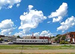
Downtown area | |
 Location of Sweetwater, Tennessee | |
| Coordinates: 35°36′9″N 84°28′1″W / 35.60250°N 84.46694°WCoordinates: 35°36′9″N 84°28′1″W / 35.60250°N 84.46694°W | |
| Country | United States |
| State | Tennessee |
| Counties | Monroe and McMinn |
| Established | 1850s[1] |
| Incorporated | 1875[1] |
| Area | |
| • Total | 6.9 sq mi (17.9 km2) |
| • Land | 6.9 sq mi (17.9 km2) |
| • Water | 0.0 sq mi (0.0 km2) |
| Elevation | 912 ft (278 m) |
| Population (2010) | |
| • Total | 5,764 |
| • Density | 810.1/sq mi (312.8/km2) |
| Time zone | Eastern (EST) (UTC-5) |
| • Summer (DST) | EDT (UTC-4) |
| ZIP code | 37874 |
| Area code(s) | 423 |
| FIPS code | 47-72540[2] |
| GNIS feature ID | 1303970[3] |
| Website |
www |
Sweetwater is a city in Monroe and McMinn counties in the U.S. state of Tennessee, and the most populous city in Monroe County. The population was 5,586 at the 2000 census and 5,764 at the 2010 census. Sweetwater is the home of the Craighead Caverns which contains the Lost Sea, the United States' largest underground lake.
History
A legend states that the town's name originated from settler's descriptions of area springs.[4]
Sweetwater was established in the 1850s on a series of lots sold by Isaac Lenoir (1807–1875), a local politician and son of the founder of Lenoir City (located a few miles to the northeast in Loudon County). Sweetwater was officially incorporated in 1875.[1]
Geography
Sweetwater is located at 35°36′9″N 84°28′1″W / 35.60250°N 84.46694°W (35.602604, -84.466992).[5] The city lies along Sweetwater Creek, which flows northeast for several miles before emptying into the Watts Bar Lake impoundment of the Tennessee River. The creek's drainage has created a lowland area known as Sweetwater Valley, which is surrounded by low hills.
Sweetwater is centered along U.S. Route 11 between its junction with State Route 68 to the south and State Route 322 to the north. Interstate 75 passes along the western boundary of Sweetwater.
According to the United States Census Bureau, the city has a total area of 6.9 square miles (17.9 km²), all land.
Sweetwater is located in a valley amidst the foothills of the Great Smoky Mountains, and is surrounded by farmland.[4]
Demographics
| Historical population | |||
|---|---|---|---|
| Census | Pop. | %± | |
| 1880 | 677 | — | |
| 1890 | 879 | 29.8% | |
| 1900 | 1,716 | 95.2% | |
| 1910 | 1,850 | 7.8% | |
| 1920 | 1,972 | 6.6% | |
| 1930 | 2,271 | 15.2% | |
| 1940 | 2,593 | 14.2% | |
| 1950 | 4,199 | 61.9% | |
| 1960 | 4,145 | −1.3% | |
| 1970 | 4,340 | 4.7% | |
| 1980 | 4,725 | 8.9% | |
| 1990 | 5,066 | 7.2% | |
| 2000 | 5,586 | 10.3% | |
| 2010 | 5,764 | 3.2% | |
| Est. 2015 | 5,931 | [6] | 2.9% |
| Sources:[7][8] | |||
As of the census[2] of 2000, there were 5,586 people, 2,315 households, and 1,537 families residing in the city. The population density was 810.1 people per square mile (312.6/km²). There were 2,511 housing units at an average density of 364.2 per square mile (140.5/km²). The racial makeup of the city was 89.72% White, 7.32% African American, 0.14% Native American, 0.91% Asian, 0.02% Pacific Islander, 0.41% from other races, and 1.47% from two or more races. Hispanic or Latino of any race were 0.95% of the population.

There were 2,315 households out of which 27.4% had children under the age of 18 living with them, 49.0% were married couples living together, 13.9% had a female householder with no husband present, and 33.6% were non-families. 30.5% of all households were made up of individuals and 14.3% had someone living alone who was 65 years of age or older. The average household size was 2.32 and the average family size was 2.87.
In the city the population was spread out with 23.0% under the age of 18, 8.1% from 18 to 24, 25.1% from 25 to 44, 23.3% from 45 to 64, and 20.5% who were 65 years of age or older. The median age was 40 years. For every 100 females there were 82.1 males. For every 100 females age 18 and over, there were 77.4 males.
The median income for a household in the city was $28,323, and the median income for a family was $35,269. Males had a median income of $29,982 versus $23,075 for females. The per capita income for the city was $16,746. About 11.5% of families and 16.4% of the population were below the poverty line, including 29.5% of those under age 18 and 18.1% of those age 65 or over.
Economy
As of 1989, most of the economy consists of agriculture business. In addition some light industry is located in Sweetwater, including a chemical factory, a hosiery mill, and a stove plant.[4] A new Walmart Supercenter opened on September 11, 2013 and added 200 jobs to the Sweetwater area.[9]
Education
Sweetwater City Schools operates public elementary and middle schools in the area. Sweetwater High School is part of Monroe County Schools.
Tennessee Meiji Gakuin High School was located in Sweetwater from 1989 to 2007.[10] It was located in the former Tennessee Military Institute.[11]
Notable people
- Butch Baker, country music artist
- Kippy Brown, NFL and collegiate coach
- North Callahan, historian and journalist
- Dwight Henry, politician
- Paul Dean Holt, former NASCAR Winston Cup driver
- Gerald North, climatologist
References
- 1 2 3 Sally Sands, "History of Sweetwater," 2006. Retrieved: 31 December 2007.
- 1 2 "American FactFinder". United States Census Bureau. Retrieved 2008-01-31.
- ↑ "US Board on Geographic Names". United States Geological Survey. 2007-10-25. Retrieved 2008-01-31.
- 1 2 3 Treadwell, David. "In Tennessee, a bastion of fading Americana, the military school, surrenders to Japanese preppies." Los Angeles Times. May 22, 1989. Section 1 National Desk, Start Page 4. Retrieved on January 12, 2012.
- ↑ "US Gazetteer files: 2010, 2000, and 1990". United States Census Bureau. 2011-02-12. Retrieved 2011-04-23.
- ↑ "Annual Estimates of the Resident Population for Incorporated Places: April 1, 2010 to July 1, 2015". Retrieved July 2, 2016.
- ↑ "Census of Population and Housing: Decennial Censuses". United States Census Bureau. Retrieved 2012-03-04.
- ↑ "Incorporated Places and Minor Civil Divisions Datasets: Subcounty Resident Population Estimates: April 1, 2010 to July 1, 2012". Population Estimates. U.S. Census Bureau. Retrieved 11 December 2013.
- ↑ http://www.news.walmart.com/news-archive/2013/09/04/walmart-ready-to-reveal-new-store-to-sweetwater-shoppers
- ↑ DiPane, Melissa. "Tennessee Meiji Gakuin School holds last graduation." WATE. March 9, 2007. Retrieved on January 11, 2012.
- ↑ Fowler, Bob. "Former Meiji Gakuin school goes to Sweet Water Sustainability Institute." The Knoxville News-Sentinel. Scripps Interactive Newspapers Group. January 8, 2011. Retrieved on January 11, 2012.
External links
- Official site
- Municipal Technical Advisory Service entry for Sweetwater — information on local government, elections, and link to charter
 Media related to Sweetwater, Tennessee at Wikimedia Commons
Municipalities and communities of McMinn County, Tennessee, United States | ||
|---|---|---|
| Cities | ||
| Towns | ||
| CDP | ||
| Unincorporated communities |
| |
| Footnotes | ‡This populated place also has portions in an adjacent county or counties | |
Municipalities and communities of Monroe County, Tennessee, United States | ||
|---|---|---|
| Cities | ||
| Towns | ||
| Unincorporated communities |
| |
| Footnotes | ‡This populated place also has portions in an adjacent county or counties | |