Athens, Tennessee
| Athens, Tennessee | |
|---|---|
| City | |
|
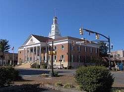
McMinn County Courthouse in Athens | |
| Nickname(s): "The Friendly City" | |
| Motto: "Progress Since 1821" | |
 Location of Athens, Tennessee | |
| Coordinates: 35°26′53″N 84°36′7″W / 35.44806°N 84.60194°W | |
| Country | United States |
| State | Tennessee |
| County | McMinn |
| Founded | 1822 |
| Incorporated | 1870[1] |
| Named for | Athens, Greece |
| Area | |
| • Total | 13.5 sq mi (35.1 km2) |
| • Land | 13.5 sq mi (35.1 km2) |
| • Water | 0.0 sq mi (0.0 km2) |
| Elevation | 860 ft (262 m) |
| Population (2010)[2] | |
| • Total | 13,548 |
| • Density | 976.3/sq mi (376.9/km2) |
| Time zone | Eastern (EST) (UTC-5) |
| • Summer (DST) | EDT (UTC-4) |
| ZIP codes | 37303 & 37371 |
| Area code(s) | 423 |
| FIPS code | 47-02320[3] |
| GNIS feature ID | 1304889[4] |
| Website |
www |
Athens is a city in McMinn County, Tennessee, United States. It is the county seat of McMinn County[5] and the principal city of the Athens Micropolitan Statistical Area, which is part of the larger Chattanooga-Cleveland-Athens Combined Statistical Area. The population was 13,220 at the 2000 census and 13,458 at the 2010 census.[6]
History
Early history and Civil War
The Cherokee were living in McMinn County at the time of the arrival of the first Euro-American explorers. The Athens area was situated nearly halfway between the Overhill Cherokee villages of Great Tellico to the north in Monroe County and Great Hiwassee along the Hiwassee River to the south. In 1819, the Cherokee signed the Calhoun Treaty, selling the land north of the Hiwassee (including all of modern McMinn County) to the United States. McMinn County was organized on November 13, 1819 at the home of John Walker in what is now Calhoun. The Native American village, Pumpkintown (a corruption of Potemkin town), was located on a farm about two miles east of present-day Athens. It is sometimes incorrectly identified as a forerunner of Athens. Athens was laid out and chosen as the county seat in 1822.[7] The name "Athens" may have been chosen due to perceived topographical similarities to Athens, Greece.[8]
By 1834, the population of Athens had grown to over 500.[9] Prominent early settlers included William Henry Cooke, who operated an iron forge near modern Etowah, and Samuel Clegg (or Cleage), a construction entrepreneur. Jesse Mayfield, whose descendants founded Mayfield Dairy Farms, arrived in the early 1820s.[10] The Hiwassee Railroad received a charter in the mid-1830s to build a railroad connecting Knoxville, Tennessee and Dalton, Georgia. The railroad began construction in 1837, although financial and legal problems delayed its completion until 1851.[8] In 1836, General John Wool arrived in Athens to help coordinate the Cherokee Removal. Although initially voluntary, the operation became a forced removal in 1838 when many Cherokee refused to leave. The removal culminated in the forced march west that became known as the Trail of Tears. Wool set up his headquarters at the Bridges Hotel, which was located across the street from the McMinn County Courthouse.[11]
McMinn County was divided during the American Civil War. The well-established railroad brought numerous pro-secessionist and anti-secessionist speakers to the county, including Andrew Johnson, Horace Maynard, John Bell, and William "Parson" Brownlow. In 1861, McMinn County voted against secession by a narrow 1,144 - 904 margin. The county sent 12 units to the Union army and 8 units to the Confederate army. General William Tecumseh Sherman was briefly headquartered at the Bridges Hotel while preparing his "March to the Sea."[12]
Post-Civil War
After the Civil War, the railroad lured business opportunists to McMinn County. In 1887, several investors established the Athens Mining and Manufacturing Company with plans to convert the town into a model industrial community and initiate large-scale mining operations in the area. Textile mills, flour mills, and timber mills dominated the county's industry by the late 19th century, complemented by furniture and appliance factories in the 1920s.[13]
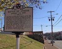
In 1946, several McMinn County World War II veterans ran for local office in hopes of removing a county government deemed corrupt. On August 1, local authorities locked themselves in the county jail along with the ballot boxes. Suspecting foul play, the veterans armed themselves and assembled on a hill across the street from the jail. After an exchange of gunfire, the county authorities surrendered. The ballots were counted, and the veterans' ticket was elected, ending the Battle of Athens.[14]
Geography
Athens is located at 35°26′53″N 84°36′7″W / 35.44806°N 84.60194°W (35.448171, -84.602069).[15] The city is situated amidst a series of narrow, elongate ridges and low hills that are characteristic of the Appalachian Ridge-and-Valley Province. The Unicoi Mountains rise roughly 20 miles (32 km) east of Athens, and the Tennessee River flows nearly 20 miles (32 km) to the west. Starr Mountain, one of the more noticeable ridges in McMinn County, is located roughly 15 miles (24 km) southeast of Athens.
Oostanaula Creek (sometimes spelled "Eastanalle" or a similar variation) rises in the hills north of Athens and traverses the city approximately 30 miles (48 km) upstream from its mouth along Hiwassee River. Other major streams in the area include Mouse Creek, which parallels Oostanaula to the west, and Chestuee Creek, which parallels Oostanaula to the east.
Athens is centered around the junction of U.S. Route 11, which connects the city to Sweetwater to the north and Cleveland to the south, and State Route 30, which connects Athens to Etowah and U.S. Route 411 to the southeast and Decatur to the west. Interstate 75 passes west of Athens.
According to the United States Census Bureau, the city has a total area of 13.5 square miles (35 km2), all land.
Demographics
| Historical population | |||
|---|---|---|---|
| Census | Pop. | %± | |
| 1860 | 678 | — | |
| 1870 | 974 | 43.7% | |
| 1880 | 1,100 | 12.9% | |
| 1890 | 2,224 | 102.2% | |
| 1900 | 1,849 | −16.9% | |
| 1910 | 2,264 | 22.4% | |
| 1920 | 2,580 | 14.0% | |
| 1930 | 5,385 | 108.7% | |
| 1940 | 6,930 | 28.7% | |
| 1950 | 8,618 | 24.4% | |
| 1960 | 12,103 | 40.4% | |
| 1970 | 11,790 | −2.6% | |
| 1980 | 12,080 | 2.5% | |
| 1990 | 12,054 | −0.2% | |
| 2000 | 13,220 | 9.7% | |
| 2010 | 13,458 | 1.8% | |
| Est. 2015 | 13,688 | [16] | 1.7% |
| Sources:[3][17][18] | |||
As of the census[3] of 2000, there were 13,220 people, 5,550 households, and 3,590 families residing in the city. The population density was 976.3 people per square mile (377.0/km²). There were 6,086 housing units at an average density of 449.4 per square mile (173.5/km²). The racial makeup of the city was 86.33% White, 9.32% African American, 0.23% Native American, 1.38% Asian, 0.07% Pacific Islander, 1.34% from other races, and 1.33% from two or more races. Hispanic or Latino of any race were 3.01% of the population.
There were 5,550 households out of which 30.0% had children under the age of 18 living with them, 47.2% were married couples living together, 14.8% had a female householder with no husband present, and 35.3% were non-families. 31.7% of all households were made up of individuals and 13.0% had someone living alone who was 65 years of age or older. The average household size was 2.29 and the average family size was 2.89.
The population consisted of 23.9% under the age of 18, 10.1% from 18 to 24, 28.3% from 25 to 44, 21.4% from 45 to 64, and 16.3% who were 65 years of age or older. The median age was 36 years. For every 100 females there were 84.8 males. For every 100 females age 18 and over, there were 80.2 males.
The median income for a household in the city was $29,277, and the median income for a family was $39,563. Males had a median income of $32,170 versus $20,917 for females. The per capita income for the city was $16,877. About 14.6% of families and 18.4% of the population were below the poverty line, including 22.6% of those under age 18 and 22.1% of those age 65 or over.
Education
Colleges:
- Cleveland State Community College
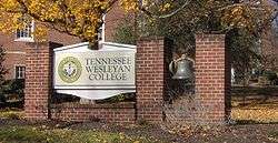
- Tennessee Wesleyan University
- Tennessee College of Applied Technology of Athens
High Schools:
- McMinn County High School
Middle Schools:
- Athens City Middle School
Elementary Schools:
- City Park
- West Side
- North City
- Ingleside
- Rogers Creek
- E.K. Baker
Economy
United Grocery Outlet, a regional discount supermarket chain, has its corporate headquarters and distribution center in Athens. [19]
Notable people
- Eric Axley - professional golfer who plays on the PGA Tour
- George Washington Bridges - Congressman and Southern Unionist
- J. Lawrence Cook - piano roll artist.[20]
- John Tyler Morgan - represented Alabama in the United States Senate as a staunch segregationist. Served in the Confederate Army as a brigadier general.[21]
- JaJuan Smith - basketball player for the University of Tennessee, played at McMinn County High School[22]
Cultural references
- Athens is the home of gunsmith Mr. Rate (Levon Helm) in the film Shooter.
- The city is mentioned in the novel Unintended Consequences as the site of the 1946 Battle of Athens.
- The characters of John and Cam board a train to Chattanooga from Athens in the novel Land of the Laguna Madre.
Athens media
Athens is served by one daily newspaper publication, The Daily Post Athenian as well as seven radio stations, (four FM, and three AM), and one Comcast TV channel, 95.
- FM
- Jack FM Country, (which is actually licensed to Decatur, Tennessee)
- WJSQ Country
- J-103 religious (licensed to Etowah, TN) simulcast with WBDX in Chattanooga
- WKPJ-LP 104.5 religious, an affiliate of 3ABN Radio Network
- AM
- WCPH 1220 Adult Standards, (licensed to Etowah, TN) an affiliate of The Music of Your Life
- WYXI 1390 Oldies
- WLAR 1450 Oldies (Formerly Simulcast of WJSQ)
See also
Climate
The climate in this area is characterized by hot, humid summers and generally mild to cool winters. According to the Köppen Climate Classification system, Athens has a humid subtropical climate, abbreviated "Cfa" on climate maps.[23]
References
- ↑ Tennessee Blue Book, 2005-2006, pp. 618-625.
- ↑ Tennessee Department of Economic and Community Development, Certified Population of Tennessee Incorporated Municipalities and Counties, State of Tennessee official website, 14 July 2011. Retrieved: 6 December 2013.
- 1 2 3 "American FactFinder". United States Census Bureau. Archived from the original on 2013-09-11. Retrieved 2008-01-31.
- ↑ "US Board on Geographic Names". United States Geological Survey. 2007-10-25. Retrieved 2008-01-31.
- ↑ "Find a County". National Association of Counties. Archived from the original on 2011-05-31. Retrieved 2011-06-07.
- ↑ "Archived copy". Archived from the original on 2013-08-07. Retrieved 2013-08-04.
- ↑ C. Stephen Byrum, McMinn County (Memphis, Tenn: Memphis State University Press, 1984), 5-9, 20.
- 1 2 Bill Akins, "City of Athens - History." Retrieved: 27 November 2007.
- ↑ Byrum, McMinn County, 21.
- ↑ Byrum, McMinn County, 11-13.
- ↑ Information obtained from the McMinn County Heritage Book Committee marker at the Bridges Hotel site (c. 1997). Information accessed: 26 November 2007.
- ↑ Byrum, McMinn County, 23-32.
- ↑ Byrum, McMinn County, 40-60.
- ↑ Information obtained from Tennessee Historical Commission marker 2A 102 in Athens, Tennessee. Information accessed: 26 November 2007.
- ↑ "US Gazetteer files: 2010, 2000, and 1990". United States Census Bureau. 2011-02-12. Retrieved 2011-04-23.
- ↑ "Annual Estimates of the Resident Population for Incorporated Places: April 1, 2010 to July 1, 2015". Retrieved July 2, 2016.
- ↑ "Census of Population and Housing". US Census Bureau. Archived from the original on 11 May 2015. Retrieved 10 December 2013.
- ↑ "Athens (city) QuickFacts". US Census Bureau. Retrieved 10 December 2013.
- ↑ "About us". Retrieved 23 February 2016.
- ↑ "J. Lawrence Cook - An Autobiography of the Early Years." Retrieved: 23 April 2008.
- ↑ "Morgan, John Tyler - Biographical Information." Biographical Directory of the United States Congress. Retrieved: 23 April 2008.
- ↑ Stan Crawley, "Crawley: Superb Play Of Vols' JaJuan Smith No Surprise To McMinn Coach." 6 February 2006. Retrieved: 23 April 2008.
- ↑ Climate Summary for Athens, Tennessee
External links
| Wikimedia Commons has media related to Athens, Tennessee. |
Coordinates: 35°26′53″N 84°36′07″W / 35.448171°N 84.602069°W
Municipalities and communities of McMinn County, Tennessee, United States | ||
|---|---|---|
| Cities | ||
| Towns | ||
| CDP | ||
| Unincorporated communities |
| |
| Footnotes | ‡This populated place also has portions in an adjacent county or counties | |