North Coast railway line, New South Wales
| North Coast Line | |||||||||||||||||||||||||||||||||||||||||||||||||||||||||||||||||||||||||||||||||||||||||||||||||||||||||||||||||||||||||||||||||||||||||||||||||||||||||||||||||||||||||||||||||||||||||||||||||||||||||||||||||||||||||||||||||||||||||||||||||||||||||||||||||||||||||||||||||||||||||||||||||||||||||||||||||||||||||||||||||||||||||||||||||||||||||||||||||||||||||||||||||||||||||||||||||||||||||||||||||||||||||||||||||||||||||||||||||||||||||||||||||||||||||||||||||||||||||||||||||||||||||||||||||||||||||||||||||||||||||||||||||||||||||||||||||||||||||||||||||||||||||||||||||||||||||||||||||||||||||||||||||||||||||||||||||||||||||||||||||||||||||||||||||||||||||||||||||||||||||||||||||||||||||||||||||||||||||||||||||||||||||||||||||||||||||||||||||||||||||||||||||||||||||||||||||||||||||||||||||||||||||||||||||||||||||||||||||||||||||||||||||||||||||||||||||||||||||||||||||||||||||||||||||||||||||||||||||||||||||||||||||||||||||||||||||||||||||||||||||||||||||||||||||||||||||||||
|---|---|---|---|---|---|---|---|---|---|---|---|---|---|---|---|---|---|---|---|---|---|---|---|---|---|---|---|---|---|---|---|---|---|---|---|---|---|---|---|---|---|---|---|---|---|---|---|---|---|---|---|---|---|---|---|---|---|---|---|---|---|---|---|---|---|---|---|---|---|---|---|---|---|---|---|---|---|---|---|---|---|---|---|---|---|---|---|---|---|---|---|---|---|---|---|---|---|---|---|---|---|---|---|---|---|---|---|---|---|---|---|---|---|---|---|---|---|---|---|---|---|---|---|---|---|---|---|---|---|---|---|---|---|---|---|---|---|---|---|---|---|---|---|---|---|---|---|---|---|---|---|---|---|---|---|---|---|---|---|---|---|---|---|---|---|---|---|---|---|---|---|---|---|---|---|---|---|---|---|---|---|---|---|---|---|---|---|---|---|---|---|---|---|---|---|---|---|---|---|---|---|---|---|---|---|---|---|---|---|---|---|---|---|---|---|---|---|---|---|---|---|---|---|---|---|---|---|---|---|---|---|---|---|---|---|---|---|---|---|---|---|---|---|---|---|---|---|---|---|---|---|---|---|---|---|---|---|---|---|---|---|---|---|---|---|---|---|---|---|---|---|---|---|---|---|---|---|---|---|---|---|---|---|---|---|---|---|---|---|---|---|---|---|---|---|---|---|---|---|---|---|---|---|---|---|---|---|---|---|---|---|---|---|---|---|---|---|---|---|---|---|---|---|---|---|---|---|---|---|---|---|---|---|---|---|---|---|---|---|---|---|---|---|---|---|---|---|---|---|---|---|---|---|---|---|---|---|---|---|---|---|---|---|---|---|---|---|---|---|---|---|---|---|---|---|---|---|---|---|---|---|---|---|---|---|---|---|---|---|---|---|---|---|---|---|---|---|---|---|---|---|---|---|---|---|---|---|---|---|---|---|---|---|---|---|---|---|---|---|---|---|---|---|---|---|---|---|---|---|---|---|---|---|---|---|---|---|---|---|---|---|---|---|---|---|---|---|---|---|---|---|---|---|---|---|---|---|---|---|---|---|---|---|---|---|---|---|---|---|---|---|---|---|---|---|---|---|---|---|---|---|---|---|---|---|---|---|---|---|---|---|---|---|---|---|---|---|---|---|---|---|---|---|---|---|---|---|---|---|---|---|---|---|---|---|---|---|---|---|---|---|---|---|---|---|---|---|---|---|---|---|---|---|---|---|---|---|---|---|---|---|---|---|---|---|---|---|---|---|---|---|---|---|---|---|---|---|---|---|---|---|---|---|---|---|---|---|---|---|---|---|---|---|---|---|---|---|---|---|---|---|---|---|---|---|---|---|---|---|---|---|---|---|---|---|---|---|---|---|---|---|---|---|---|---|---|---|---|---|---|---|---|---|---|---|---|---|---|---|---|---|---|---|---|---|---|---|---|---|---|---|---|---|---|---|---|---|---|---|---|---|---|---|---|---|---|---|---|---|---|---|---|---|---|---|---|---|---|---|---|---|---|---|---|---|---|---|---|---|---|---|---|---|---|---|---|---|---|---|---|---|---|---|---|---|---|---|---|---|---|---|---|---|---|---|---|---|---|---|---|---|---|---|---|---|---|---|---|---|---|---|---|---|---|---|---|---|---|---|---|---|---|---|---|---|---|---|---|---|---|---|---|---|---|---|---|---|---|---|---|---|---|---|---|---|---|---|---|---|---|---|---|---|---|---|---|---|---|---|---|---|---|---|---|---|---|---|---|---|---|---|---|---|---|---|---|---|---|---|---|---|---|---|---|---|---|---|---|---|---|---|---|---|---|---|---|---|---|---|---|---|---|---|---|---|---|---|---|---|---|---|---|---|---|---|---|---|---|---|---|---|---|---|---|---|---|---|---|---|---|---|---|---|---|---|---|---|---|---|---|---|---|---|---|---|---|---|---|---|---|---|---|---|---|---|---|---|---|---|---|---|---|---|---|---|---|---|---|---|---|---|---|---|---|---|---|---|---|---|---|---|---|---|---|---|---|---|---|---|---|---|---|---|---|---|---|---|---|---|---|---|---|---|---|---|---|---|---|---|---|---|---|---|---|---|---|---|---|---|---|---|---|---|---|---|---|---|---|---|---|---|---|---|---|---|---|---|---|---|---|---|---|---|---|---|---|---|---|---|---|---|---|---|---|---|---|---|---|---|---|---|---|---|---|---|---|---|---|---|---|---|---|---|---|---|---|---|---|---|---|---|---|---|---|---|---|---|---|---|
|
| |||||||||||||||||||||||||||||||||||||||||||||||||||||||||||||||||||||||||||||||||||||||||||||||||||||||||||||||||||||||||||||||||||||||||||||||||||||||||||||||||||||||||||||||||||||||||||||||||||||||||||||||||||||||||||||||||||||||||||||||||||||||||||||||||||||||||||||||||||||||||||||||||||||||||||||||||||||||||||||||||||||||||||||||||||||||||||||||||||||||||||||||||||||||||||||||||||||||||||||||||||||||||||||||||||||||||||||||||||||||||||||||||||||||||||||||||||||||||||||||||||||||||||||||||||||||||||||||||||||||||||||||||||||||||||||||||||||||||||||||||||||||||||||||||||||||||||||||||||||||||||||||||||||||||||||||||||||||||||||||||||||||||||||||||||||||||||||||||||||||||||||||||||||||||||||||||||||||||||||||||||||||||||||||||||||||||||||||||||||||||||||||||||||||||||||||||||||||||||||||||||||||||||||||||||||||||||||||||||||||||||||||||||||||||||||||||||||||||||||||||||||||||||||||||||||||||||||||||||||||||||||||||||||||||||||||||||||||||||||||||||||||||||||||||||||||||||||
| Overview | |||||||||||||||||||||||||||||||||||||||||||||||||||||||||||||||||||||||||||||||||||||||||||||||||||||||||||||||||||||||||||||||||||||||||||||||||||||||||||||||||||||||||||||||||||||||||||||||||||||||||||||||||||||||||||||||||||||||||||||||||||||||||||||||||||||||||||||||||||||||||||||||||||||||||||||||||||||||||||||||||||||||||||||||||||||||||||||||||||||||||||||||||||||||||||||||||||||||||||||||||||||||||||||||||||||||||||||||||||||||||||||||||||||||||||||||||||||||||||||||||||||||||||||||||||||||||||||||||||||||||||||||||||||||||||||||||||||||||||||||||||||||||||||||||||||||||||||||||||||||||||||||||||||||||||||||||||||||||||||||||||||||||||||||||||||||||||||||||||||||||||||||||||||||||||||||||||||||||||||||||||||||||||||||||||||||||||||||||||||||||||||||||||||||||||||||||||||||||||||||||||||||||||||||||||||||||||||||||||||||||||||||||||||||||||||||||||||||||||||||||||||||||||||||||||||||||||||||||||||||||||||||||||||||||||||||||||||||||||||||||||||||||||||||||||||||||||||
| Type | Heavy rail | ||||||||||||||||||||||||||||||||||||||||||||||||||||||||||||||||||||||||||||||||||||||||||||||||||||||||||||||||||||||||||||||||||||||||||||||||||||||||||||||||||||||||||||||||||||||||||||||||||||||||||||||||||||||||||||||||||||||||||||||||||||||||||||||||||||||||||||||||||||||||||||||||||||||||||||||||||||||||||||||||||||||||||||||||||||||||||||||||||||||||||||||||||||||||||||||||||||||||||||||||||||||||||||||||||||||||||||||||||||||||||||||||||||||||||||||||||||||||||||||||||||||||||||||||||||||||||||||||||||||||||||||||||||||||||||||||||||||||||||||||||||||||||||||||||||||||||||||||||||||||||||||||||||||||||||||||||||||||||||||||||||||||||||||||||||||||||||||||||||||||||||||||||||||||||||||||||||||||||||||||||||||||||||||||||||||||||||||||||||||||||||||||||||||||||||||||||||||||||||||||||||||||||||||||||||||||||||||||||||||||||||||||||||||||||||||||||||||||||||||||||||||||||||||||||||||||||||||||||||||||||||||||||||||||||||||||||||||||||||||||||||||||||||||||||||||||||||
| Status | Open | ||||||||||||||||||||||||||||||||||||||||||||||||||||||||||||||||||||||||||||||||||||||||||||||||||||||||||||||||||||||||||||||||||||||||||||||||||||||||||||||||||||||||||||||||||||||||||||||||||||||||||||||||||||||||||||||||||||||||||||||||||||||||||||||||||||||||||||||||||||||||||||||||||||||||||||||||||||||||||||||||||||||||||||||||||||||||||||||||||||||||||||||||||||||||||||||||||||||||||||||||||||||||||||||||||||||||||||||||||||||||||||||||||||||||||||||||||||||||||||||||||||||||||||||||||||||||||||||||||||||||||||||||||||||||||||||||||||||||||||||||||||||||||||||||||||||||||||||||||||||||||||||||||||||||||||||||||||||||||||||||||||||||||||||||||||||||||||||||||||||||||||||||||||||||||||||||||||||||||||||||||||||||||||||||||||||||||||||||||||||||||||||||||||||||||||||||||||||||||||||||||||||||||||||||||||||||||||||||||||||||||||||||||||||||||||||||||||||||||||||||||||||||||||||||||||||||||||||||||||||||||||||||||||||||||||||||||||||||||||||||||||||||||||||||||||||||||||
| Locale | Mid North Coast and Northern Rivers regions of New South Wales | ||||||||||||||||||||||||||||||||||||||||||||||||||||||||||||||||||||||||||||||||||||||||||||||||||||||||||||||||||||||||||||||||||||||||||||||||||||||||||||||||||||||||||||||||||||||||||||||||||||||||||||||||||||||||||||||||||||||||||||||||||||||||||||||||||||||||||||||||||||||||||||||||||||||||||||||||||||||||||||||||||||||||||||||||||||||||||||||||||||||||||||||||||||||||||||||||||||||||||||||||||||||||||||||||||||||||||||||||||||||||||||||||||||||||||||||||||||||||||||||||||||||||||||||||||||||||||||||||||||||||||||||||||||||||||||||||||||||||||||||||||||||||||||||||||||||||||||||||||||||||||||||||||||||||||||||||||||||||||||||||||||||||||||||||||||||||||||||||||||||||||||||||||||||||||||||||||||||||||||||||||||||||||||||||||||||||||||||||||||||||||||||||||||||||||||||||||||||||||||||||||||||||||||||||||||||||||||||||||||||||||||||||||||||||||||||||||||||||||||||||||||||||||||||||||||||||||||||||||||||||||||||||||||||||||||||||||||||||||||||||||||||||||||||||||||||||||||
| Termini |
Maitland Brisbane Roma Street | ||||||||||||||||||||||||||||||||||||||||||||||||||||||||||||||||||||||||||||||||||||||||||||||||||||||||||||||||||||||||||||||||||||||||||||||||||||||||||||||||||||||||||||||||||||||||||||||||||||||||||||||||||||||||||||||||||||||||||||||||||||||||||||||||||||||||||||||||||||||||||||||||||||||||||||||||||||||||||||||||||||||||||||||||||||||||||||||||||||||||||||||||||||||||||||||||||||||||||||||||||||||||||||||||||||||||||||||||||||||||||||||||||||||||||||||||||||||||||||||||||||||||||||||||||||||||||||||||||||||||||||||||||||||||||||||||||||||||||||||||||||||||||||||||||||||||||||||||||||||||||||||||||||||||||||||||||||||||||||||||||||||||||||||||||||||||||||||||||||||||||||||||||||||||||||||||||||||||||||||||||||||||||||||||||||||||||||||||||||||||||||||||||||||||||||||||||||||||||||||||||||||||||||||||||||||||||||||||||||||||||||||||||||||||||||||||||||||||||||||||||||||||||||||||||||||||||||||||||||||||||||||||||||||||||||||||||||||||||||||||||||||||||||||||||||||||||||
| Operation | |||||||||||||||||||||||||||||||||||||||||||||||||||||||||||||||||||||||||||||||||||||||||||||||||||||||||||||||||||||||||||||||||||||||||||||||||||||||||||||||||||||||||||||||||||||||||||||||||||||||||||||||||||||||||||||||||||||||||||||||||||||||||||||||||||||||||||||||||||||||||||||||||||||||||||||||||||||||||||||||||||||||||||||||||||||||||||||||||||||||||||||||||||||||||||||||||||||||||||||||||||||||||||||||||||||||||||||||||||||||||||||||||||||||||||||||||||||||||||||||||||||||||||||||||||||||||||||||||||||||||||||||||||||||||||||||||||||||||||||||||||||||||||||||||||||||||||||||||||||||||||||||||||||||||||||||||||||||||||||||||||||||||||||||||||||||||||||||||||||||||||||||||||||||||||||||||||||||||||||||||||||||||||||||||||||||||||||||||||||||||||||||||||||||||||||||||||||||||||||||||||||||||||||||||||||||||||||||||||||||||||||||||||||||||||||||||||||||||||||||||||||||||||||||||||||||||||||||||||||||||||||||||||||||||||||||||||||||||||||||||||||||||||||||||||||||||||||
| Opened | 6 November 1905 | ||||||||||||||||||||||||||||||||||||||||||||||||||||||||||||||||||||||||||||||||||||||||||||||||||||||||||||||||||||||||||||||||||||||||||||||||||||||||||||||||||||||||||||||||||||||||||||||||||||||||||||||||||||||||||||||||||||||||||||||||||||||||||||||||||||||||||||||||||||||||||||||||||||||||||||||||||||||||||||||||||||||||||||||||||||||||||||||||||||||||||||||||||||||||||||||||||||||||||||||||||||||||||||||||||||||||||||||||||||||||||||||||||||||||||||||||||||||||||||||||||||||||||||||||||||||||||||||||||||||||||||||||||||||||||||||||||||||||||||||||||||||||||||||||||||||||||||||||||||||||||||||||||||||||||||||||||||||||||||||||||||||||||||||||||||||||||||||||||||||||||||||||||||||||||||||||||||||||||||||||||||||||||||||||||||||||||||||||||||||||||||||||||||||||||||||||||||||||||||||||||||||||||||||||||||||||||||||||||||||||||||||||||||||||||||||||||||||||||||||||||||||||||||||||||||||||||||||||||||||||||||||||||||||||||||||||||||||||||||||||||||||||||||||||||||||||||||
| Owner |
New South Wales Government Railways (1905-15) Department of Railways (1915-72) Public Transport Commission (1972-80) State Rail Authority (1980-2003) RailCorp (2003-present) | ||||||||||||||||||||||||||||||||||||||||||||||||||||||||||||||||||||||||||||||||||||||||||||||||||||||||||||||||||||||||||||||||||||||||||||||||||||||||||||||||||||||||||||||||||||||||||||||||||||||||||||||||||||||||||||||||||||||||||||||||||||||||||||||||||||||||||||||||||||||||||||||||||||||||||||||||||||||||||||||||||||||||||||||||||||||||||||||||||||||||||||||||||||||||||||||||||||||||||||||||||||||||||||||||||||||||||||||||||||||||||||||||||||||||||||||||||||||||||||||||||||||||||||||||||||||||||||||||||||||||||||||||||||||||||||||||||||||||||||||||||||||||||||||||||||||||||||||||||||||||||||||||||||||||||||||||||||||||||||||||||||||||||||||||||||||||||||||||||||||||||||||||||||||||||||||||||||||||||||||||||||||||||||||||||||||||||||||||||||||||||||||||||||||||||||||||||||||||||||||||||||||||||||||||||||||||||||||||||||||||||||||||||||||||||||||||||||||||||||||||||||||||||||||||||||||||||||||||||||||||||||||||||||||||||||||||||||||||||||||||||||||||||||||||||||||||||||
| Technical | |||||||||||||||||||||||||||||||||||||||||||||||||||||||||||||||||||||||||||||||||||||||||||||||||||||||||||||||||||||||||||||||||||||||||||||||||||||||||||||||||||||||||||||||||||||||||||||||||||||||||||||||||||||||||||||||||||||||||||||||||||||||||||||||||||||||||||||||||||||||||||||||||||||||||||||||||||||||||||||||||||||||||||||||||||||||||||||||||||||||||||||||||||||||||||||||||||||||||||||||||||||||||||||||||||||||||||||||||||||||||||||||||||||||||||||||||||||||||||||||||||||||||||||||||||||||||||||||||||||||||||||||||||||||||||||||||||||||||||||||||||||||||||||||||||||||||||||||||||||||||||||||||||||||||||||||||||||||||||||||||||||||||||||||||||||||||||||||||||||||||||||||||||||||||||||||||||||||||||||||||||||||||||||||||||||||||||||||||||||||||||||||||||||||||||||||||||||||||||||||||||||||||||||||||||||||||||||||||||||||||||||||||||||||||||||||||||||||||||||||||||||||||||||||||||||||||||||||||||||||||||||||||||||||||||||||||||||||||||||||||||||||||||||||||||||||||||||
| Line length | 795 km (494 mi) | ||||||||||||||||||||||||||||||||||||||||||||||||||||||||||||||||||||||||||||||||||||||||||||||||||||||||||||||||||||||||||||||||||||||||||||||||||||||||||||||||||||||||||||||||||||||||||||||||||||||||||||||||||||||||||||||||||||||||||||||||||||||||||||||||||||||||||||||||||||||||||||||||||||||||||||||||||||||||||||||||||||||||||||||||||||||||||||||||||||||||||||||||||||||||||||||||||||||||||||||||||||||||||||||||||||||||||||||||||||||||||||||||||||||||||||||||||||||||||||||||||||||||||||||||||||||||||||||||||||||||||||||||||||||||||||||||||||||||||||||||||||||||||||||||||||||||||||||||||||||||||||||||||||||||||||||||||||||||||||||||||||||||||||||||||||||||||||||||||||||||||||||||||||||||||||||||||||||||||||||||||||||||||||||||||||||||||||||||||||||||||||||||||||||||||||||||||||||||||||||||||||||||||||||||||||||||||||||||||||||||||||||||||||||||||||||||||||||||||||||||||||||||||||||||||||||||||||||||||||||||||||||||||||||||||||||||||||||||||||||||||||||||||||||||||||||||||||
| Track gauge | 1,435 mm (4 ft 8 1⁄2 in) | ||||||||||||||||||||||||||||||||||||||||||||||||||||||||||||||||||||||||||||||||||||||||||||||||||||||||||||||||||||||||||||||||||||||||||||||||||||||||||||||||||||||||||||||||||||||||||||||||||||||||||||||||||||||||||||||||||||||||||||||||||||||||||||||||||||||||||||||||||||||||||||||||||||||||||||||||||||||||||||||||||||||||||||||||||||||||||||||||||||||||||||||||||||||||||||||||||||||||||||||||||||||||||||||||||||||||||||||||||||||||||||||||||||||||||||||||||||||||||||||||||||||||||||||||||||||||||||||||||||||||||||||||||||||||||||||||||||||||||||||||||||||||||||||||||||||||||||||||||||||||||||||||||||||||||||||||||||||||||||||||||||||||||||||||||||||||||||||||||||||||||||||||||||||||||||||||||||||||||||||||||||||||||||||||||||||||||||||||||||||||||||||||||||||||||||||||||||||||||||||||||||||||||||||||||||||||||||||||||||||||||||||||||||||||||||||||||||||||||||||||||||||||||||||||||||||||||||||||||||||||||||||||||||||||||||||||||||||||||||||||||||||||||||||||||||||||||||
| |||||||||||||||||||||||||||||||||||||||||||||||||||||||||||||||||||||||||||||||||||||||||||||||||||||||||||||||||||||||||||||||||||||||||||||||||||||||||||||||||||||||||||||||||||||||||||||||||||||||||||||||||||||||||||||||||||||||||||||||||||||||||||||||||||||||||||||||||||||||||||||||||||||||||||||||||||||||||||||||||||||||||||||||||||||||||||||||||||||||||||||||||||||||||||||||||||||||||||||||||||||||||||||||||||||||||||||||||||||||||||||||||||||||||||||||||||||||||||||||||||||||||||||||||||||||||||||||||||||||||||||||||||||||||||||||||||||||||||||||||||||||||||||||||||||||||||||||||||||||||||||||||||||||||||||||||||||||||||||||||||||||||||||||||||||||||||||||||||||||||||||||||||||||||||||||||||||||||||||||||||||||||||||||||||||||||||||||||||||||||||||||||||||||||||||||||||||||||||||||||||||||||||||||||||||||||||||||||||||||||||||||||||||||||||||||||||||||||||||||||||||||||||||||||||||||||||||||||||||||||||||||||||||||||||||||||||||||||||||||||||||||||||||||||||||||||||||
- The North Coast railway line is also a railway in Queensland, Australia
The North Coast Line is the primary rail route in the Mid North Coast and Northern Rivers regions of New South Wales, Australia, and forms a major part of the Sydney–Brisbane rail corridor.
The line begins at Maitland and ends at Roma Street railway station in Brisbane, although freight services terminate at the yard at Acacia Ridge on the outskirts of Brisbane. Along the way, the railway passes through the towns of Dungog, Gloucester, Wingham, Taree, Kendall, Wauchope, Kempsey, Macksville, Nambucca Heads, Urunga, Sawtell, Coffs Harbour, Grafton, Casino and Kyogle. After the standard gauge line ends at Acacia Ridge, it forms a dual gauge line into Brisbane, running alongside parts of the Beenleigh railway line.
Since the Main Northern Line was closed north of Armidale in 1988, the North Coast line is now the only route between Sydney and Queensland. With the closure of former branches to Dorrigo (1972) and Murwillumbah (2004) there are now no operating branches off the line.
The Bonalbo branch from Casino was stillborn, with partial construction left incomplete.
At the NSW/Queensland border is a long tunnel called Border Tunnel. Immediately south of it was Border Loop, a short crossing loop, which is now closed. About one kilometre south of that is the Cougal Spiral. These two locations are often confused, Border Loop is not Cougal Spiral.
The line is owned by RailCorp but leased to the Australian Rail Track Corporation until 2064.[1][2][3]
History


The first North Coast railway was opened between Murwillumbah, Byron Bay and Lismore in 1894 and extended to Casino in 1903 and Grafton in 1905. A branch line was built to Kyogle in 1910 and extended to South Brisbane in 1930.
The line was built between 1905 and 1932, and when completed, bypassed the Main North line and provided a quicker route up the eastern seaboard. The development of the line was hampered by the many large rivers that flow through the North Coast. The line also features the Cougal Spiral, which is one of only two spirals in New South Wales.
A railway was built from Maitland to Paterson and Dungog in 1911. It was extended to Gloucester and Taree in 1913 and Wauchope, Kempsey, Coffs Harbour, Glenreagh and South Grafton (now Grafton station) in 1915.[4]
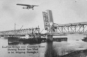
The Clarence River was the most difficult river to cross and it was not crossed until 1932.[4][5] In the meantime services were connected by rail ferry that carried the carriages across the river. The opening of the Grafton Bridge in 1932 completed the Sydney – Brisbane line as the first standard gauge inter-capital link.
The completion of the Sydney–Brisbane link saw the Casino–Murwillumbah line become a branch line.[6] In 1930 a branch line had been added to Ballina but this closed in 1949.[7] The Murwillumbah branch closed in 2004.
A picturesque branch was opened from Glenreagh to Dorrigo in 1924, but was difficult to maintain due to the steep terrain and high rainfall and it was closed in 1972 after a washaway.[8] The Glenreagh to Ulong section is proposed for reopening as a heritage tourist railway by the Glenreagh Mountain Railway. The Dorrigo Steam Railway is also being set up in Dorrigo as a museum and working exhibit.
Passenger services


Current services
NSW TrainLink operates three daily XPT services from Sydney to Grafton, Casino and Brisbane.[9]
Freight services
When the Main North Line was closed north of Armidale in 1988, super-freighters to Brisbane began using the North Coast Line, operated by the State Rail Authority, then National Rail. Today, freight services on the North Coast Line are operated by Pacific National and Aurizon. These superfreighters do not serve any of the towns they pass through - in the government railways era, there would be regular freight services to towns such as Kempsey, Grafton and Casino. The only freight train that regularly services the North Coast Line is a cement and sugar train for Grafton.
Historical services
The premier trains on the North Coast line were the two daily services to Brisbane, the Brisbane Limited and the Brisbane Express. The Limited was the fastest service, stopping only at major stations, while the Express operated as a sweeper service stopping at most stations north of Grafton and provided connections to services on the Murwillumbah branch.[10] Air-conditioned Sleeping cars had operated on the Brisbane Limited from 1960. In April 1973 the Brisbane Express was withdrawn and replaced by the Gold Coast Motorail, operating to Murwillumbah. The North Coast Daylight Express and North Coast Mail operated to Grafton until they were both replaced in 1985 by a single Holiday Coast XPT train. Following the Booz Allen Hamilton review of 1989 which recommended severe rationalisation of country rail services, the Brisbane and Murwillumbah services were converted to XPT operation in February 1990, and a locomotive hauled Grafton Express service to Grafton introduced in June 1990.[11] In November 1993 the Grafton Express was also converted to XPT operation.[12]
Improvement Works
The North Coast Line has significant curvature, equivalent to turning through 150 circles – 75.5 to the right and 74.5 to the left heading north, the difference of one circle due to the Cougal Spiral in the Border Ranges. Of course the curves are unevenly distributed meaning that maximum speeds change hundreds of times usually within the range of 60 km/hr and 115 km/hr for freight trains.
The Australian Rail Track Corporation has recently resleepered the track with concrete sleepers, upgraded the signals and installed new loops to increase efficiency. In mid-2011 they eased about 58 sections of curves on the line, increasing line speed for the XPT and freight trains. The curve easing was done without land purchases, so the track changes would be minor, staying within the existing corridor.
Location List
This is a list of all the locations and crossing loops on the North Coast line.
| Location | Distance from Sydney | Signal Prefix |
|---|---|---|
| Telarah | 194.5 | MD |
| Mindaribba | 203.5 | 02 |
| Paterson | 213.2 | 03 |
| Martins Creek | 218.5 | 04 |
| Kilbride | 223.5 | 05 |
| Hilldale | 226.2 | |
| Wallarobba | 231.7 | |
| Wallarobba Loop | 234.0 | 06 |
| Wirragulla | 238.0 | |
| Dungog | 245.2 | 07 |
| North Dungog | 247.2 | 07 |
| Monkerai | 254.0 | 08 |
| Stroud Road | 266.5 | 09 |
| Duralie | 272.8 | 09 |
| Weismantels | 278.1 | |
| South Craven | 290.5 | 11 |
| North Craven | 292.5 | 11 |
| Berrico | 301.9 | 12 |
| Gloucester | 309.3 | 13 |
| Yumbunga (closed) | 316.4 | 14 |
| Bulliac | 324.1 | 15 |
| Bundook | 334.4 | 16 |
| Mount George | 342.1 | 17 |
| Kimbriki (closed) | 353.2 | 18 |
| Killawarra | 360.3 | 19 |
| Wingham | 367.1 | 20 |
| Taree | 378.6 | 21 |
| Melinga | 392.3 | 22 |
| Coopernook | 403.6 | 23 |
| Johns River | 417.7 | 24 |
| Kendall | 433.0 | 25 |
| Kerewong | 445.8 | 26 |
| Wauchope | 455.0 | 27 |
| Telegraph Point | 472.5 | 28 |
| Kundabung | 487.2 | 29 |
| Kempsey | 503.5 | 30 |
| Collombatti | ||
| Tamban | 520.6 | 31 |
| Barraganyatti | ||
| Eungai | 534.6 | 32 |
| Warrell Creek | ||
| Macksville | 552.4 | |
| Nambucca Heads | 565.1 | 34 |
| Urunga | 580.9 | |
| Raleigh | 586.5 | 35 |
| Bonville | 596.5 | 36 |
| Sawtell | 600.7 | |
| Boambee Beach | 606.8 | 37 |
| Coffs Harbour | 608.1 | 37 |
| Landrigans | 619.6 | 38 |
| Coramba | 628.0 | 39 |
| Nana Glen | 640.3 | 40 |
| Glenreagh | 651.9 | 41 |
| Kungala | 664.3 | 42 |
| Braunstone | 683.3 | 43 |
| Grafton | 695.7 | 44 |
| Old Grafton | 698.8 | 45 |
| Koolkhan | 706.8 | |
| Kyarran | 713.6 | 46 |
| Lawrence Road | 738.7 | 47 |
| Camira Creek | ||
| Rappville | 776.2 | 50 |
| Leeville (closed) | 793.7 | 51 |
| Casino | 805.1 | 52 |
| Nammoona | 810.1 | CO |
| Kyogle | 833.8 | |
| Kyogle Loop | 837.1 | KE |
| Loadstone | 863.5 | LE |
| Border Loop | 875.1 | |
| NSW/Queensland Border | 876.0 | |
| Glenapp | 887.6 | GP |
| Tamrookum | 909.3 | TM |
| Bromelton | 931.7 | BN |
| Greenbank | 955.6 | GK |
| Acacia Ridge | AR | |
| Salisbury Junction | 975.976 | SY |
| Clapham Loop | CM | |
| Yeerongpilly | YY | |
| Dutton Park Junction | DP | |
| South Brisbane | SB | |
| Roma Street | RS |
See also
References
- ↑ Memorandum between The Commonwealth of Australia & The State of New South Wales & Australian Rail Track Corporation Limited Australian Rail Track Corporation
- ↑ The Agreement in Summary Australian Rail Track Corporation
- ↑ Annual Report 30 June 2004 Australian Rail Track Corporation
- 1 2 "North Coast Line". www.nswrail.net. Retrieved 2006-11-21.
- ↑ "Crossing the Clarence" Roundhouse July 1982 pages 4-23
- ↑ "Murwillumbah Branch". www.nswrail.net. Retrieved 2006-11-21.
- ↑ "Ballina Branch". www.nswrail.net. Retrieved 2006-11-21.
- ↑ "Dorrigo Branch". www.nswrail.net. Retrieved 2006-11-21.
- ↑ "North Coast timetable" (PDF). NSW Trainlink. 20 October 2013 [Updated 6 April 2014].
- ↑ Milne, R. The last days of the Brisbane Express and the Brisbane Limited. Bulletin, ARHS. Vol 49, no 724. Feb 1998.
- ↑ "An Obituary to the Grafton Express" Railway Digest January 1994
- ↑ "Ten Years of the North Coast XPTs" Railway Digest February 2000
Bibliography
- Avery, Rod (2006). Freight Across the Nation: The Australian Superfreighter Experience. Brisbane: Copyright Publishing Co. ISBN 1876344474.
- North Coast Line of the New South Wales Railways, Australian Railway Historical Society Bulletin, August, 1984, pp 169–183.
| |||||||||||||||||
| |||||||||||||||||
| |||||||||||||||||
| |||||||||||||||||