Paterson River
| Paterson River |
|
| Yimmang River, Cedar Arms River[1] |
|
| Perennial river |
|
| |
| Name origin: In honour of William Paterson[1] |
|
|
| Country |
Australia |
| State |
New South Wales |
| Regions |
NSW North Coast (IBRA), Hunter, Mid North Coast |
| Local government areas |
Dungog; Maitland; Port Stephens |
|
|
| Part of |
Hunter River catchment |
| Tributaries |
| - left |
Sheepstation Creek, Allyn River, Dunns Creek (New South Wales) |
| - right |
Boonabilla Creek, Horse Creek (New South Wales), Fenwicks Creek |
| Towns |
Gresford, Vacy, Paterson, Woodville, Hinton |
| Landmark |
Lostock Dam |
|
|
|
|
| Source |
Barrington Tops |
| - location |
near Careys Peak |
| - elevation |
256 m (840 ft) |
| - coordinates |
32°3′43.26″S 151°24′57″E / 32.0620167°S 151.41583°E / -32.0620167; 151.41583 |
| Mouth |
Hunter River |
| - location |
Hinton |
| - elevation |
3 m (10 ft) |
| - coordinates |
32°43′7.7″S 151°38′33.7″E / 32.718806°S 151.642694°E / -32.718806; 151.642694Coordinates: 32°43′7.7″S 151°38′33.7″E / 32.718806°S 151.642694°E / -32.718806; 151.642694 |
|
|
| Length |
159 km (99 mi) |
|
|
| National park |
Barrington Tops National Park |
| Reservoir |
Lostock Dam |
|
|
| [1][2] |
|
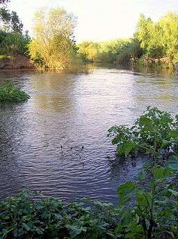
Paterson River, a perennial river[1] that is part of the Hunter River catchment, is located in the Hunter and Mid North Coast regions of New South Wales, Australia.
Course and features
Paterson River rises in the Barrington Tops National Park, west by north of Careys Peak, and flows generally south and southeast, joined by six minor tributaries including the Allyn River at Vacy, before reaching its confluence with the Hunter River between Hinton and Morpeth.[1] Between Hinton and Duns Creek, the Paterson River forms the border between the Port Stephens and Maitland local government areas. The river system courses through fertile the farming land of the Paterson and Allyn River Valleys and the historic Patersons Plains; descending 933 metres (3,061 ft) over its 151 kilometres (94 mi) course.[2]
The river is impounded by Lostock Dam, located 48 kilometres (30 mi) downstream from the source in the Barringtons. The embankment dam was constructed by the New South Wales Department of Water Resources to supply water for irrigation and was completed in 1971.[3][4] The river is tidal to above the village of Paterson and below Vacy.
Riverside towns within the Paterson's catchment include Gresford, Vacy, Paterson, Woodville and Hinton.
Colonel William Paterson surveyed the area along the river in 1801. Later Governor King named it in his honour.[1]
References
External links
|
|---|
|
| |
|---|
|
- Backwater
- Bakers
- Beean Beean
- Belbora
- Ben Halls
- Berrico
- Buggs
- Burrell
- Callaghans Swamp
- Clear Hill
- Dog Trap
- Mackays
- Mograni
- Myall
- Oaky
- Orham
- Pipeclay Gully
- Sandy
- Schofields
- Scotts
- Tindag
- Titaatee
- Tomalla
- Tuggolo
- Waukivory
- Wild Cattle
- Williams
|
|
|
| |
|---|
|
- Alderley
- Black Bullock
- Blue Gum
- Boggy
- Boomerang
- Booral
- Bungwahl
- Bunyah
- Candoormakh
- Carrington
- Carrs
- Caseys
- Deep
- Firefly
- Horse
- Kelly
- Khoribakh
- Kundle
- Kyle
- Lamans
- Lawlers
- Lewis
- Limeburners
- Little Branch
- Little Myall
- Martins
- Mill
- Monkey Jacket
- Oakey
- Pipers
- Scotters
- Sharpers
- Snapes
- Spring
- Sugar
- Talawahl
- Teatree
- Terreel
- Waterloo
- Whispering Gully
|
|
|
|
|
|
|
|---|
|
| Towns, suburbs and localities |
- Alison
- Allynbrook
- Anleys Creek
- Bandon Grove
- Barrington Tops
- Bendolba
- Bingleburra
- Black Camp
- Bonnington
- Bonnington Park
- Brookfield
- Brownmore
- Cairnsmore
- Cambra
- Camyr Allyn
- Cangon
- Carrabolla
- Cawarra
- Chads Creek
- Chichester
- Cintra
- Clarence Town
- Clarence Town West
- Clay Hill
- Colstoun
- Cooreei
- Coulston
- Crooks Park
- Dingadee
- Douribang
- Dungog
- Dusodie
- East Gresford
- Eccleston
- Elms Hall
- Fishers Hill
- Flat Tops
- Fosterton
- Glen Martin
- Glen Oak
- Glen William
- Gresford
- Halton
- Hanleys Creek
- Hilldale
- Kenilworth
- Kilbride
- Lennoxton
- Lewinsbrook
- Lostock
- Lyndhurst Vale
- Main Creek
- Marshdale
- Martins Creek
- Masseys Creek
- Maxwells Creek
- Melbee
- Mill Hills
- Mount Rivers
- Munni
- Paterson
- Pine Brush
- Quartpot
- Raglan
- Salisbury
- Sugarloaf
- Summerhill
- Tabbil Creek
- Tillegra
- Tillimby
- Torryburn
- Trevallyn
- Tunnibuc
- Underbank
- Upper Allyn
- Upper Chichester
- Vacy
- Wallaringa
- Wallarobba
- Wangat
- Webbers Creek
- Welshmans Creek
- Wirragulla
- Woerden
|
|---|
|
| Rivers and other waterways | |
|---|
|
| Other places and points of interest | |
|---|
|
|---|
|
Towns, suburbs
and localities | |
|---|
|
Other places and
points of interest | |
|---|
|
|---|
|
Towns, suburbs
and localities | |
|---|
|
Other places and
points of interest | |
|---|
|
|---|
|
|
|
|
|
| Entertainment, sport and culture |
|---|
| |
|
|
|
|
| Historical |
|---|
| | Air transport | |
|---|
| | Defence | |
|---|
| | Education | |
|---|
| | General | |
|---|
| | Industry | |
|---|
| | Maritime | |
|---|
| | Natural disasters | |
|---|
| | People | |
|---|
| | Rail | | General | |
|---|
| | Railway lines | |
|---|
| | Railway stations | |
|---|
| | Trams | |
|---|
|
|---|
| | Wine making | |
|---|
| | World War II | |
|---|
|
|
|
| Infrastructure |
|---|
| | Transport | | Road | |
|---|
| | Railway lines | |
|---|
| | Railway stations | |
|---|
| | Bus | |
|---|
| | Air | |
|---|
|
|---|
| | Utilities | | Electricity generation | |
|---|
| | Water supply | |
|---|
|
|---|
|
|
|
|
|
|