Clarence River (New South Wales)
| Clarence River (Breimba or Berrinbah[1]) | |
| Big River[2] | |
| A mature wave dominated, barrier estuary[3] | |
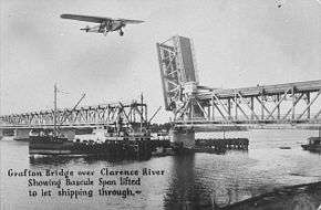
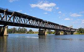 The Grafton Bridge across the Clarence River. | |
| Name origin: In honour of the Duke of Clarence[2] | |
| Country | Australia |
|---|---|
| State | New South Wales |
| Regions | NSW North Coast (IBRA), Northern Rivers |
| Local government areas | Kyogle, Clarence Valley |
| Tributaries | |
| - left | Nymboida River, Mann River, Tooloom Creek, Cataract River, Orara River, Esk River |
| - right | Coldstream River, Timbarra River |
| City | Grafton |
| Primary source | Border Ranges |
| - location | near Tooloom National Park and Bonalbo |
| - elevation | 252 m (827 ft) |
| Secondary source | Maryland River |
| Mouth | Coral Sea, South Pacific Ocean |
| - location | near Iluka and Yamba |
| - coordinates | 29°43′S 153°37′E / 29.717°S 153.617°ECoordinates: 29°43′S 153°37′E / 29.717°S 153.617°E |
| Length | 394 km (245 mi) |
| Depth | 2.2 m (7 ft) |
| Volume | 283,001 m3 (9,994,086 cu ft) |
| Basin | 22,850 km2 (8,822 sq mi) |
| Area | 132 km2 (51 sq mi) |
| Discharge | |
| - average | 160 m3/s (5,650 cu ft/s) |
| - max | 20,000 m3/s (706,293 cu ft/s) |
| - min | 1 m3/s (35 cu ft/s) |
| River islands | Woodford Island, Chatsworth Island, and Harwood Island |
| Website: NSW Environment and Heritage webpage | |
| [4] | |
The Clarence River (Aboriginal: Breimba or Berrinbah[1]), a mature wave dominated, barrier estuary,[3] is situated in the Northern Rivers district of New South Wales, Australia.
The river rises on the eastern slopes of the Great Dividing Range, in the Border Ranges west of Bonalbo, near Rivertree at the junction of Koreelah Creek and Maryland River, on the watershed that marks the border between New South Wales and Queensland. The river flows generally south, south east and north east, joined by twenty-four tributaries including the Tooloom Creek and the Mann, Nymboida, Cataract, Orara, Coldstream, Timbarra, and Esk rivers. The river reaches its mouth at its confluence with the Coral Sea in the South Pacific Ocean, between Iluka and Yamba; descending 256 metres (840 ft) over the course of its 394 kilometres (245 mi) length.[4]
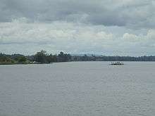
On its journey it passes through the towns of Tabulam and Copmanhurst, the city of Grafton, and the towns of Ulmarra, and Maclean. The river features many large river islands, including Woodford, Chatsworth, Ashby, Warregah and Harwood islands; and Susan Island Nature Reserve. The river supports a large prawn trawling and fishing industry.
The Clarence River system is an extensive east coast drainage with many tributaries of differing size. Apart from the Murray River, it is the largest river in mainland Australia south of the Tropic of Capricorn, though its flow for comparison is only half that of the Potomac. Its basin is, together with the very similarly-sized Hawkesbury, Australia's largest Pacific watershed south of Bundaberg. The extremely intense rainfalls that typify the North Coast mean, however, that major floods can temporarily raise the flow of the Clarence to levels equivalent to some of the largest rivers in the world.
Rainfall and climate


The climate of most of the basin is subtropical (Köppen Cfa), though the highest areas with cooler weather are of the temperate Cfb type. Annual rainfall ranges from 1,600 millimetres (63 in) on the coast at Yamba down to 1,080 millimetres (43 in) in the shielded valley at Grafton (BOM Grafton Olympic Pool). At higher altitudes, rainfall may reach 2,000 millimetres (79 in) on exposed slopes but data are very poor. Most of the high areas actually receive no more rain than Grafton though variability from year to year is less. Temperatures are generally very warm, with maxima in lower area ranging from 27 °C (81 °F) in January to 19 °C (66 °F) in July. In the highlands, however, temperatures are much cooler and in July range from lows of around 2 °C (36 °F) to maxima around 13 °C (55 °F) - though in January days remain very warm at around 25 °C (77 °F). Rainfall per month on the coast typically ranges from around 220 millimetres (8.7 in) in February and March to around 70 millimetres (2.8 in) in September; it can average as low as 40 millimetres (1.6 in) between May and September inland, where exposed areas sometimes suffer bushfires after droughts, as occurred in 1915 and 2000.
Flooding
During the 2013 Eastern Australia floods, the Clarence was subject to minor flooding, brought about due to the residual effects of Tropical Cyclone Oswald and associated monsoon trough that passed over parts of Queensland and New South Wales. At Grafton, the river peaked at a new record height of 8.1 metres (27 ft).[5] Two years earlier, the river peaked 7.6 metres (25 ft), forcing the evacuation of 3000 people from their homes.[6] On both occasions, the city's levee was credited with preventing more severe flooding.
The local historical society has published an account of newspaper reports documenting flooding of the river from the late 1800s to 2011.[7]
Catchment land use and industry
Tourism is also a significant industry in the Clarence Valley generating around A$457million per annum and employing around 2500 people. Most of the Clarence basin is heavily forested, with important areas of remnant subtropical and temperate rainforest occurring all along the course. Only in alluvial areas where soils are less leached is there major agricultural development: in these areas the chief industries are cattle rearing and the growing of sugar cane in lower-lying areas.
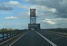
Of particular interest is the small island town of Harwood, where a Sperry New Holland factory and a quaint Bush Pub overlook the Clarence delta. Harwood is also the location of the local sugar mill, the Harwood Sugar Mill built in 1873 and is the oldest Australian mill still operational. The sugar mill is situated on the river due to its importance in transporting sugar cane from farms in the surrounding area in previous times. Harwood is just after the Harwood Bridge on part of Australia's National Highway from Sydney, Port Macquarie, Coffs Harbour to Brisbane.
The freshwater reaches of the Clarence River support important populations of native freshwater fish including Eastern freshwater cod, an endangered fish species unique to the Clarence River system, and Australian bass.
Etymology
The Aboriginal people of the lower reaches call the river Breimba or Berrinbah.[1] Meanwhile, the Aboriginal people from the Tenterfield district used the word neyand, meaning "top" as the name for the headwaters of the river.[2]
The river was named by Capt. Henry Rous in honour of The Prince William, 1st Duke of Clarence and St Andrews and Lord High Admiral of the Navy prior to his ascension as William IV.[2]
The local government area of the Clarence Valley Council draws its name from the river and covers the lower half of the river valley.
Crossings
There are very few fixed crossings of the Clarence River. Going downstream, these include:
- Bridge over Hootens Rd Bonalbo
- Bridge at Tabulam, on the Bruxner Highway
- Bridge at Lilydale near Copmanhurst
- Rogan Bridge, a bridge that carries the Rogan Bridge Rd
- Grafton Bridge at Grafton
- Ulmarra-Southgate Ferry at Ulmarra
- Harwood Bridge at Harwood
- Bluff Point Ferry at Lawrence
Crossings over the south arm of the Clarence River are:
- Wingfield Bridge at Cowper
- McFarlane Bridge at Maclean
Crossings over the north arm of the Clarence River are:
- Mororo Bridge at Mororo, New South Wales
- Warregah Island Bridge, Chatsworth Island, New South Wales
- Sepentine Channel Bridge at Harwood
See also
References
- 1 2 3 Hoff, Jennifer (2006). Bunjalung Jugun (Bunjalung Country). Richmond River Historical Society. ISBN 1-875474-24-2.
Yamba Yesterday, Howland and Lee, Yamba Centenary Committee, 1985
- 1 2 3 4 "Clarence River". Geographical Names Register (GNR) of NSW. Geographical Names Board of New South Wales. Retrieved 29 January 2013.
- 1 2 Roy, P. S; Williams, R. J; Jones, A. R; Yassini, I; et al. (2001). "Structure and Function of South-east Australian Estuaries". Estuarine, Coastal and Shelf Science. 53: 351–384. doi:10.1006/ecss.2001.0796.
- 1 2 "Map of Clarence River". Bonzle.com. Retrieved 29 January 2013.
- ↑ "Thousands isolated as flood threat continues". ABC News. Australia. 30 January 2013. Retrieved 30 January 2013.
- ↑ Drummond, Andrew (21 January 2011). "People take flood in stride as thoughts turn north". The Age. Australia. Retrieved 30 January 2013.
- ↑ "Publications produced by the Society". Clarence River Historical Society Inc. 2012. Retrieved 30 January 2013.
Further reading
- Ford, Hazel, ed. (2011). When the rains come down the floods come up: Grafton Floods. Clarence River Historical Society Inc.
External links
| Wikimedia Commons has media related to Clarence River (New South Wales). |
River systems and rivers of the Northern Rivers catchments, New South Wales, Australia | |||||||
|---|---|---|---|---|---|---|---|
| |||||||
| |||||||
| |||||||
| |||||||
| |||||||
| |||||||
| |||||||
|