Williams River (New South Wales)
For other uses, see Williams River.
| Williams River | |
| Perennial stream | |
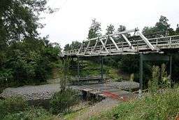 The Williams River at Dungog | |
| Country | Australia |
|---|---|
| State | New South Wales |
| Regions | NSW North Coast (IBRA), Hunter Region, Mid North Coast |
| Local government areas | Dungog Shire, Upper Hunter Shire, Port Stephens |
| Part of | Hunter River catchment |
| Tributaries | |
| - left | Chichester River, Carowiry Creek, Black Camp Creek |
| - right | Myall Creek (New South Wales), Tabbil Creek, Wallarobba Creek, Unwarrabin Creek, Chambers Creek (New South Wales), Tumbledown Creek, Stony Creek (New South Wales) |
| Towns | Raymond Terrace, Seaham, Clarence Town, Dungog |
| Landmark | Seaham Weir |
| Source | Careys Peak, Barrington Tops |
| - location | near Salisbury |
| - elevation | 747 m (2,451 ft) |
| - coordinates | 32°3′7″S 151°28′43.4″E / 32.05194°S 151.478722°E [1] |
| Mouth | confluence with Hunter River |
| - location | Raymond Terrace, Hunter Region |
| - elevation | 1 m (3 ft) |
| - coordinates | 32°45′S 151°45′E / 32.750°S 151.750°ECoordinates: 32°45′S 151°45′E / 32.750°S 151.750°E [2] |
| Length | 142 km (88 mi) |
| National park | Barrington Tops NP |
| [3][4] | |
The Williams River is a perennial stream that is a tributary of the Hunter River, in the Hunter Region of New South Wales, Australia.
Course and features
The Williams River rises on the southern slopes of the Barrington Tops below Careys Peak within Barrington Tops National Park, and flows generally southeast and south, joined by ten tributaries including Chichester River, before reaching its confluence with the Hunter River at Raymond Terrace. The river descends 749 metres (2,457 ft) over its 142 kilometres (88 mi) course;[4] through Dungog, Clarence Town and Seaham.
See also
Gallery
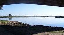 Confluence of the Hunter and Williams rivers.
References
- ↑ Topographic maps 9133 Camberwell, 91331N Barrington Tops
- ↑ Topographic maps 9232 Newcastle, 92323N Beresfield
- ↑ "Williams River". Geographical Names Register (GNR) of NSW. Geographical Names Board of New South Wales. Retrieved 3 March 2013.
- 1 2 "Map of Williams River, NSW". Bonzle Digital Atlas of Australia. Retrieved 3 March 2013.
External links
- "Hunter River catchment" (map). Office of Environment and Heritage. Government of New South Wales.
River systems and rivers of Hunter-Central Rivers catchment, New South Wales, Australia | |||||||
|---|---|---|---|---|---|---|---|
| |||||||
| |||||||
| |||||||
|
This article is issued from Wikipedia - version of the 7/26/2016. The text is available under the Creative Commons Attribution/Share Alike but additional terms may apply for the media files.