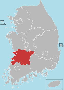
North Jeolla Province
| North Jeolla Province 전라북도 | ||
|---|---|---|
| Province | ||
| Korean transcription(s) | ||
| • Hangul | 전라북도 | |
| • Hanja | 全羅北道 | |
| • McCune‑Reischauer | Chŏllabuk-to | |
| • Revised Romanization | Jeollabuk-do | |
| ||
 | ||
| Country | South Korea | |
| Region | Honam | |
| Capital | Jeonju | |
| Subdivisions | 6 cities; 8 counties | |
| Government | ||
| • Governor | Song ha-jin | |
| Area | ||
| • Total | 8,067 km2 (3,115 sq mi) | |
| Area rank | 7th | |
| Population (December, 2015) | ||
| • Total | 1,869,711 | |
| • Density | 232/km2 (600/sq mi) | |
| Metropolitan Symbols | ||
| • Flower | Zinnia | |
| • Tree | Ginkgo | |
| • Bird | Magpie | |
| Dialect | Jeolla | |
| Website | Travel Information | |

North Jeolla Province or Jeollabuk-do (전라북도; 全羅北道; Jeollabuk-do) is a province in the southwest of South Korea. The province was formed in 1896 from the northern half of the former Jeolla province, and remained a province of Korea until the country's division in 1945, then became part of South Korea. The provincial capital is located at Jeonju, which was the capital of all of Jeolla before 1896.
Jeollabuk-do has the most fertile fields in the Republic of Korea. Its mountains and fields have been a source of life, providing the fine foods of Korea. It is the hometown that preserves and passes down traditional Korean tastes, fashions and culture, and is a beautiful land filled with magnificent scenery and nature.
History
During the Proto-Three Kingdoms period, Jeolla region was the center of the Mahan confederacy among Samhan. There were 15 tribal countries out of 54 located in the region. During the period of the Three States, this region came to belong to Baekje when it absorbed Mahan. Baekje was destroyed by the Silla and Chinese Tang dynasty allied force in 660 (20th year of King Uija) and ruled by Tang. It became a part of Silla when Tang was expelled in 676 (16th year of King Munmu).
When there were 9 states and 5 small capitals in Unified Silla in 685, there were Wansan-ju (present Jeonju) and Namwon-gyeong (present Namwon) in Jeollabuk-do in existence.
In 892, when General Gyeon Hwon founded Hubaekje (later Baekje), this area continued to exist and was the center of the country for about 50 years. In 936, during the rule of Singeom, it was attributed to Goryeo Dynasty. From 900 to the time when Hubaekje was attributed to Goryeo, Wansan-ju (present Jeonju) had been its capital, and the country ruled the whole Jeolla-do region.
In 996 (14th year of King Sungjong), this region was named as the Gangnam province, and the Korean government established the 4 states (Jeonju-Jeonju area, Yeongju-Gobu area, Sunju-Sunchang area and Maju-Okgu area) in North Jeolla region.
Gangnam-do (Jeonbuk) and Haenam-do (Jeonnam) were combined and titled as Jeolla-do in 1018 (9th year of King Hyeonjong's reign).
During the Joseon Dynasty, as the administrative districts of the whole nation were organized in Eight Provinces system in 1413 (13th year of King Taejong's reign), Jeolla-do took charge of vast areas of: one prefecture, 4-autonomous counties, 4-protectorates, 12-counties, and 31-counties covering present Jeollanam-do, Jeollabuk-do and Jeju-do.
In 1896 (33rd year of King Gojong's reign), the whole country was divided into 13 provinces. Jeolla-do was divided into Jeollanam-do and Jeollabuk-do. Jeollabuk-do consisted of 26 counties.
In 1963, Geumsan-gun was incorporated into Chungnam, and Wido-myeon of Jeonnam was incorporated into Jeonbuk. Jeongju-eup and Namwon-eup were raised to cities in 1981 and Gimje-eup was raised to city status in 1989. Wansan-gu and Deokjin-gu were established in Jeonju-city in the same year.
Due to establishment of cities in the mixed type of city-farming area in 1995, Okgu, Jeungeup, Namwon, Gimje and Iksan-Guns were combined. Gimje and Iksan-guns were merged and Gunsan, Jeonju, Namwon, Gimje and Iri cities were integrated. Through repeated reorganizations of administrative districts, now the region consists of the administrative districts of 6 cities and 8 counties.
Geographical location of Jeollabuk-do
Jeollabuk-do is located in the west-southern part of Korea, bordered on the east-southern by Hadong-gun, Hamyang-gun, and Geochang-gun of Gyeongnam, and Gimcheon-si of Gyeongbuk, Bangyabong Peak of Sobaek Mountain (1,732m), Toggibong Peak (1,534m), Myeongseungbong Peak (1,586m), Baekwoonsan Mountain (1,279m), Namdeokyusan Mountain (1,508m), and Muyongsan Mountain (1,492m), on the south by Yeongwang-gun, Jangseong-gun, Damyang-gun, Gokseong-gun, and Gure-gun, on the north by Geumsan-gun, Nonsan-si, Buyeo -gun, and Seocheon-gun of Choongnam, and Yeongdong-gun of Choongbuk, and on the west by China over the Yellow Sea.
The total area of Jeollabuk-do is 8,067 square kilometres (3,115 sq mi), which accounts for 8.1% of the total area of South Korea.
Festival of Jeollabuk-do[1]
1. Global party, united in sound Jeonju International Sori Festival
Jeonju International Sori Festival is a high-quality worldwide music art festival based on Pansori, Korea’s Intangible Cultural Heritage. It is designed to promote Korean music to the world, and exchange diverse musical heritages of many nations though sounds as meditation. Jeonju International Sori Festival was selected as one of the ‘Best 25 International Festivals’ by the world famous UK music magazine Songlines in 2012 and 2013.
http://www.sorifestival.com
2. Immerse yourself in the rich culture of fermentation, set to change the world International Fermented Food Expo, Jeonju
The International Fermented Food Expo is the only extra-large international food market where Jeollabuk-do’s abundance of good food and global fermented food can be tasted all together. It is an industrial exhibition where new fermented products, technical information, and recent industry trends can be gleaned. Approximately 3,000 food companies, buyers, and food research institutions have participated since 2003. It has helped Jeollabuk-do standout as an industrial Korean food center with a great track records promoting production - with 17.6 billion KRW (won), tourism with 550,000 visitors in 2002, value – with 13.8 billion KRW (won), and employment promotion – hiring 733 people.
http://www.iffe.or.kr
3. A dynamic feast of symbols Jeollabuk-do World Calligraphy Biennale
The Jeollabuk-do World Calligraphy Biennale was launched in favor of popularizing and globalizing Korean calligraphy in 1997. Since then, the art of calligraphy, the quintessence of Chinese character culture in East Asia, has gained global interest among calligraphers and the public over the years. The infinite potential of Calligraphy is found here in the Jeollabuk-do World Calligraphy Biennale.
http://www.biennale.or.kr
Transportation and industry
In the 1960s the Honam highway (which has since been upgraded to the Honam Expressway) was built. This created an industrial belt, connecting the cities of Iri (now called Iksan) and Gunsan (a port city) with the provincial capital of Jeonju.
- Airline information [2]
Flight visitors to Jeollabuk-do would be surely satisfied if using Gunsan Airport service. Public transportation networks are served to Jeonju and other cities in Jeollabuk-do when visitors use Gunsan Airport.
- Jeju International Airport → Gunsan Airport : 2 times a day/ 50 minutes flight
- Gunsan Airport→ Jeonju : Airport Shuttle service/ 1 hour running
- Gunsan intercity bus service for other cities and counties
Religion
Religion in North Jeolla (2005)
According to the census of 2005[3](The survey is conducted in every 10 years), of the people of North Jeolla 37.7% follow Christianity (26.3% Protestantism and 11.4% Catholicism) and 12.8% follow Buddhism.49.5% of the population is mostly not religious or follow Muism and other indigenous religions.
International Sisterhood relationship & partnership
- Sisterhood relationship
-
 Jiangsu, People's Republic of China (27 October 1994)
 -
 Washington, United States (17 May 1996)
 - New Jersey State,United States (19 May 2000)
-
- Partnership
-
 Kagoshima Prefecture, Japan (30 October 1989)
 - Ishikawa Prefecture, Japan (10 September 2001)
- Shanghai, People's Republic of China (17 April 2003)
- Shandong, People's Republic of China (2 November 2006)
-
Administrative divisions
| Map | # | Name | Hangul | Hanja | Population (2015) | Subdivisions |
|---|---|---|---|---|---|---|
 | ||||||
| — Specific City — | ||||||
| 1 | Jeonju | 전주시 | 全州市 | 652,282 | 2 ilban-gu — 33 haengjeong-dong | |
| — City — | ||||||
| 2 | Iksan | 익산시 | 益山市 | 302,061 | 1 eup, 14 myeon, 14 haengjeong-dong | |
| 3 | Gunsan | 군산시 | 群山市 | 278,398 | 1 eup, 10 myeon, 16 haengjeong-dong | |
| 4 | Jeongeup | 정읍시 | 井邑市 | 115,977 | 1 eup, 14 myeon, 8 haengjeong-dong | |
| 5 | Gimje | 김제시 | 金堤市 | 88,721 | 1 eup, 14 myeon, 4 haengjeong-dong | |
| 6 | Namwon | 남원시 | 南原市 | 84,856 | 1 eup, 15 myeon, 7 haengjeong-dong | |
| — County — | ||||||
| 7 | Wanju County | 완주군 | 完州郡 | 95,303 | 3 eup, 10 myeon | |
| 8 | Gochang County | 고창군 | 高敞郡 | 60,046 | 1 eup, 13 myeon | |
| 9 | Buan County | 부안군 | 扶安郡 | 56,848 | 1 eup, 12 myeon | |
| 10 | Sunchang County | 순창군 | 淳昌郡 | 30,248 | 1 eup, 10 myeon | |
| 11 | Imsil County | 임실군 | 任實郡 | 30,271 | 1 eup, 11 myeon | |
| 12 | Muju County | 무주군 | 茂朱郡 | 25,220 | 1 eup, 5 myeon | |
| 13 | Jinan County | 진안군 | 鎭安郡 | 26,203 | 1 eup, 10 myeon | |
| 14 | Jangsu County | 장수군 | 長水郡 | 23,277 | 1 eup, 6 myeon | |
See also
References
External links
-
 North Jeolla travel guide from Wikivoyage
 - Official site
- North Jeolla Province news
- Travel Information
Jeonju (capital) | ||||
| Specific city |
| ||
| Cities | ||||
| Counties | ||||
| Regions | |
|---|---|
| Provinces | |
| Special self-governing province | |
| Special city | |
| Special self-governing city | |
| Metropolitan cities | |
| The Committee for the Five Northern Korean Provinces | |
Coordinates: 35°49′N 127°09′E / 35.817°N 127.150°E