Moscow, Ohio
| Moscow, Ohio | |
|---|---|
| Village | |
| Motto: "...a peaceful spot on the River" | |
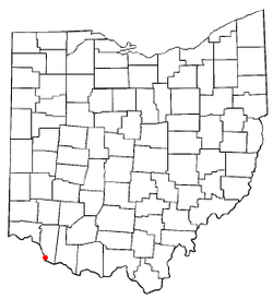 Location of Moscow, Ohio | |
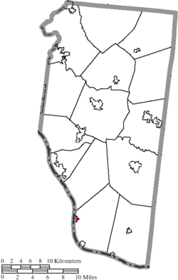 Location of Moscow in Clermont County | |
| Coordinates: 38°51′26″N 84°13′43″W / 38.85722°N 84.22861°WCoordinates: 38°51′26″N 84°13′43″W / 38.85722°N 84.22861°W | |
| Country | United States |
| State | Ohio |
| County | Clermont |
| Township | Washington |
| Government | |
| • Mayor | Tim Suter |
| Area[1] | |
| • Total | 0.39 sq mi (1.01 km2) |
| • Land | 0.37 sq mi (0.96 km2) |
| • Water | 0.02 sq mi (0.05 km2) |
| Elevation[2] | 499 ft (152 m) |
| Population (2010)[3] | |
| • Total | 185 |
| • Estimate (2012[4]) | 185 |
| • Density | 500.0/sq mi (193.1/km2) |
| Time zone | Eastern (EST) (UTC-5) |
| • Summer (DST) | EDT (UTC-4) |
| ZIP code | 45153 |
| Area code(s) | 513 |
| FIPS code | 39-52416[5] |
| GNIS feature ID | 1056435[2] |
Moscow is a village in Clermont County, Ohio, United States. The population was 185 at the 2010 census.
The William H. Zimmer Power Station, a nuclear power plant converted to coal-fired generation that creates 1300-megawatts of electricity, is partially located within village limits.
History
Moscow was platted in 1816.[6] The name may have been given to the town by French immigrants who were veterans of Napoleon's siege of Moscow.[7] A post office called Moscow has been in operation since 1826.[8]
On March 2, 2012, a tornado destroyed over 80% of the town and caused three deaths, as multiple tornadoes ripped through Indiana, Kentucky and Ohio.[9]
Gallery
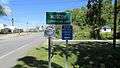 Moscow corporation limit sign.
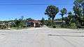 Looking east on Broadway Street in Moscow.
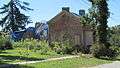 Damage from March 2, 2012 tornado.
 Damage from March 2, 2012 tornado.
Geography
Moscow is located at 38°51′26″N 84°13′43″W / 38.85722°N 84.22861°W (38.857258, -84.228609),[10] along the Ohio River.
According to the United States Census Bureau, the village has a total area of 0.39 square miles (1.01 km2), of which 0.37 square miles (0.96 km2) is land and 0.02 square miles (0.05 km2) is water.[1]
Demographics
| Historical population | |||
|---|---|---|---|
| Census | Pop. | %± | |
| 1860 | 434 | — | |
| 1870 | 443 | 2.1% | |
| 1880 | 516 | 16.5% | |
| 1890 | 591 | 14.5% | |
| 1900 | 475 | −19.6% | |
| 1910 | 327 | −31.2% | |
| 1920 | 274 | −16.2% | |
| 1930 | 293 | 6.9% | |
| 1940 | 309 | 5.5% | |
| 1950 | 336 | 8.7% | |
| 1960 | 438 | 30.4% | |
| 1970 | 348 | −20.5% | |
| 1980 | 324 | −6.9% | |
| 1990 | 279 | −13.9% | |
| 2000 | 244 | −12.5% | |
| 2010 | 185 | −24.2% | |
| Est. 2015 | 186 | [11] | 0.5% |
2010 census
As of the census[3] of 2010, there were 185 people, 81 households, and 51 families residing in the village. The population density was 500.0 inhabitants per square mile (193.1/km2). There were 96 housing units at an average density of 259.5 per square mile (100.2/km2). The racial makeup of the village was 98.4% White, 1.1% African American, and 0.5% from other races. Hispanic or Latino of any race were 1.6% of the population.
There were 81 households of which 24.7% had children under the age of 18 living with them, 44.4% were married couples living together, 18.5% had a female householder with no husband present, and 37.0% were non-families. 30.9% of all households were made up of individuals and 11.1% had someone living alone who was 65 years of age or older. The average household size was 2.28 and the average family size was 2.80.
The median age in the village was 47.7 years. 16.8% of residents were under the age of 18; 6.9% were between the ages of 18 and 24; 21.1% were from 25 to 44; 39.9% were from 45 to 64; and 15.1% were 65 years of age or older. The gender makeup of the village was 51.9% male and 48.1% female.
2000 census
As of the census[5] of 2000, there were 244 people, 91 households, and 64 families residing in the village. The population density was 606.3 people per square mile (235.5/km²). There were 104 housing units at an average density of 258.4 per square mile (100.4/km²). The racial makeup of the village was 97.13% White, 0.41% African American, 0.41% Native American, 0.41% Asian, 0.41% from other races, and 1.23% from two or more races.
There were 91 households out of which 38.5% had children under the age of 18 living with them, 51.6% were married couples living together, 17.6% had a female householder with no husband present, and 28.6% were non-families. 26.4% of all households were made up of individuals and 9.9% had someone living alone who was 65 years of age or older. The average household size was 2.68 and the average family size was 3.26.
In the village the population was spread out with 29.1% under the age of 18, 6.6% from 18 to 24, 30.3% from 25 to 44, 23.0% from 45 to 64, and 11.1% who were 65 years of age or older. The median age was 36 years. For every 100 females there were 98.4 males. For every 100 females age 18 and over, there were 88.0 males.
The median income for a household in the village was $31,563, and the median income for a family was $33,125. Males had a median income of $30,357 versus $26,250 for females. The per capita income for the village was $12,491. About 14.3% of families and 19.9% of the population were below the poverty line, including 34.6% of those under the age of eighteen and none of those sixty five or over.
See also
References
- 1 2 "US Gazetteer files 2010". United States Census Bureau. Retrieved 2013-01-06.
- 1 2 "US Board on Geographic Names". United States Geological Survey. 2007-10-25. Retrieved 2008-01-31.
- 1 2 "American FactFinder". United States Census Bureau. Retrieved 2013-01-06.
- ↑ "Population Estimates". United States Census Bureau. Retrieved 2013-06-17.
- 1 2 "American FactFinder". United States Census Bureau. Retrieved 2008-01-31.
- ↑ Thwaites, Reuben Gold (20 December 2007). Early Western Travels, 1748-1846. Reprint Services Corporation. p. 155. ISBN 978-0-7812-6455-6.
- ↑ Karle, Tina. "120 Waterfall Hikes Around Cincinnati Ohio". Lulu.com. p. 17. Retrieved 27 November 2013.
- ↑ "Clermont County". Jim Forte Postal History. Retrieved 16 January 2016.
- ↑ http://www.local12.com/news/local/story/One-Death-Reported-in-Moscow-Damage-Widespread-in/uWHoHPkWA0yU3t9fZ2zzQg.cspx
- ↑ "US Gazetteer files: 2010, 2000, and 1990". United States Census Bureau. 2011-02-12. Retrieved 2011-04-23.
- ↑ "Annual Estimates of the Resident Population for Incorporated Places: April 1, 2010 to July 1, 2015". Retrieved July 2, 2016.
- ↑ "Census of Population and Housing". Census.gov. Retrieved June 4, 2015.
Municipalities and communities of Clermont County, Ohio, United States | ||
|---|---|---|
| Cities | 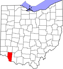 | |
| Villages | ||
| Townships | ||
| CDPs | ||
| Unincorporated communities |
| |
| Ghost towns | ||
| Footnotes | ‡This populated place also has portions in an adjacent county or counties | |