Tate Township, Clermont County, Ohio
| Tate Township, Clermont County, Ohio | |
|---|---|
| Township | |
|
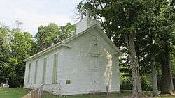
Former Bethel Methodist Church | |
 Location of Tate Township in Clermont County | |
| Coordinates: 38°57′27″N 84°5′43″W / 38.95750°N 84.09528°WCoordinates: 38°57′27″N 84°5′43″W / 38.95750°N 84.09528°W | |
| Country | United States |
| State | Ohio |
| County | Clermont |
| Area | |
| • Total | 47.5 sq mi (122.9 km2) |
| • Land | 46.6 sq mi (120.7 km2) |
| • Water | 0.8 sq mi (2.2 km2) |
| Elevation[1] | 879 ft (268 m) |
| Population (2010) | |
| • Total | 9,357 |
| • Density | 201/sq mi (77.5/km2) |
| Time zone | Eastern (EST) (UTC-5) |
| • Summer (DST) | EDT (UTC-4) |
| FIPS code | 39-76155[2] |
| GNIS feature ID | 1085871[1] |
| Website |
tatetownship |
Tate Township is one of the fourteen townships of Clermont County, Ohio, United States. The 2010 census reported 9,357 people living in the township,[3] 6,646 of whom were in the unincorporated portions of the township.
Geography
Located in the southeastern part of the county, it borders the following townships:
- Williamsburg Township - north
- Pike Township, Brown County - northeast corner
- Clark Township, Brown County - east
- Lewis Township, Brown County - southeast
- Franklin Township - south
- Washington Township - southwest
- Monroe Township - west
- Batavia Township - northwest
The village of Bethel is located in central Tate Township. Public education is provided by the Bethel-Tate School District.
Name and history
It is the only Tate Township statewide.[4]
Government
The township is governed by a three-member board of trustees, who are elected in November of odd-numbered years to a four-year term beginning on the following January 1. Two are elected in the year after the presidential election and one is elected in the year before it. There is also an elected township fiscal officer,[5] who serves a four-year term beginning on April 1 of the year after the election, which is held in November of the year before the presidential election. Vacancies in the fiscal officership or on the board of trustees are filled by the remaining trustees.
References
- 1 2 "US Board on Geographic Names". United States Geological Survey. 2007-10-25. Retrieved 2008-01-31.
- ↑ "American FactFinder". United States Census Bureau. Retrieved 2008-01-31.
- ↑ "Geographic Identifiers: 2010 Demographic Profile Data (G001): Tate township, Clermont County, Ohio". U.S. Census Bureau, American Factfinder. Retrieved January 16, 2015.
- ↑ "Detailed map of Ohio" (PDF). United States Census Bureau. 2000. Retrieved 2007-02-16.
- ↑ §503.24, §505.01, and §507.01 of the Ohio Revised Code. Accessed 4/30/2009.
External links
Municipalities and communities of Clermont County, Ohio, United States | ||
|---|---|---|
| Cities | 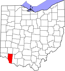 | |
| Villages | ||
| Townships | ||
| CDPs | ||
| Unincorporated communities |
| |
| Ghost towns | ||
| Footnotes | ‡This populated place also has portions in an adjacent county or counties | |