Ohio State Route 245
| |||||||
|---|---|---|---|---|---|---|---|
 | |||||||
| Route information | |||||||
| Maintained by ODOT | |||||||
| Length: | 36.03 mi[1] (57.98 km) | ||||||
| Existed: | 1962[2][3] – present | ||||||
| Major junctions | |||||||
| West end: |
| ||||||
| East end: |
| ||||||
| Location | |||||||
| Counties: | Champaign, Logan, Union | ||||||
| Highway system | |||||||
| |||||||

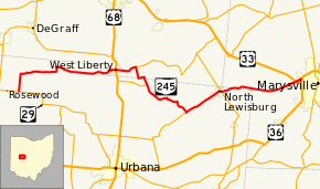
State Route 245 (SR 245) is an east–west state highway in the western portion of the U.S. state of Ohio. The western terminus of SR 245 is at an intersection with SR 29 near Rosewood. Its eastern terminus is at an exit ramp with U.S. Route 33 (US 33), US 36, and SR 4 in Marysville.
Route description
SR 245 travels through the northern portion of Champaign County, the southern portion of Logan County and then re-enters Champaign County; the highway also travels through the western part of Union County. No segment of this highway is a part of the National Highway System.[4]
History
SR 245 was first designated in 1962. The original routing of the highway consisted of the same route as today.[2][3] Prior to June 1963, SR 245 was signed as SR 275.[3] The route was renumbered at that time due to Ohio renumbering state highways sharing the same number as Interstate highways;[3] Interstate 275 forced the renumbering of SR 275.
Major intersections
| County | Location | mi[1] | km | Destinations | Notes | |||
|---|---|---|---|---|---|---|---|---|
| Champaign | Adams Township | 0.00 | 0.00 | |||||
| Logan | West Liberty | 12.48 | 20.08 | |||||
| Monroe Township | 14.69 | 23.64 | Western terminus of SR 287 | |||||
| Champaign |
No major junctions | |||||||
| Logan |
No major junctions | |||||||
| Champaign | Salem Township | 17.29 | 27.83 | Eastern terminus of SR 507 | ||||
| Wayne Township | 22.93 | 36.90 | Eastern terminus of SR 296 | |||||
| North Lewisburg | 26.92 | 43.32 | Western end of SR 559 concurrency | |||||
| 27.17 | 43.73 | Eastern end of SR 559 concurrency | ||||||
| Union | Paris Township | 34.95– 35.08 | 56.25– 56.46 | Partial interchange; access to US 33 westbound and from US 33 eastbound only | ||||
| Paris Township–Marysville line | 35.68– 36.03 | 57.42– 57.98 | Interchange | |||||
1.000 mi = 1.609 km; 1.000 km = 0.621 mi
| ||||||||
See also
 Ohio portal
 U.S. Roads portal
References
- 1 2 "DESTAPE". Ohio Department of Transportation. June 24, 2015. Retrieved November 11, 2015.
- 1 2 Map of Ohio State Highways (MrSID) (Map). Cartography by ODHPW. Ohio Department of Highways and Public Works. 1961. Retrieved May 12, 2013.
- 1 2 3 4 Map of Ohio Showing State Routes (MrSID) (Map). Cartography by ODHPW. Ohio Department of Highways and Public Works. 1962. Retrieved May 12, 2013.
- ↑ National Highway System: Ohio (PDF) (Map). Cartography by FHWA. Federal Highway Administration. December 2003. Retrieved January 8, 2011.