Old Washington, Ohio
| Old Washington, Ohio | |
|---|---|
| Village | |
|
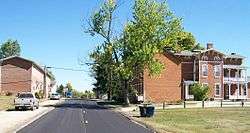
Downtown Old Washington | |
 Location of Old Washington, Ohio | |
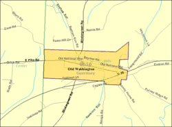 Detailed map of Old Washington | |
| Coordinates: 40°2′14″N 81°26′27″W / 40.03722°N 81.44083°WCoordinates: 40°2′14″N 81°26′27″W / 40.03722°N 81.44083°W | |
| Country | United States |
| State | Ohio |
| County | Guernsey |
| Township | Wills |
| Area[1] | |
| • Total | 0.67 sq mi (1.74 km2) |
| • Land | 0.67 sq mi (1.74 km2) |
| • Water | 0 sq mi (0 km2) |
| Elevation[2] | 1,014 ft (309 m) |
| Population (2010)[3] | |
| • Total | 279 |
| • Estimate (2012[4]) | 278 |
| • Density | 416.4/sq mi (160.8/km2) |
| Time zone | Eastern (EST) (UTC-5) |
| • Summer (DST) | EDT (UTC-4) |
| ZIP code | 43768 |
| Area code(s) | 740 |
| FIPS code | 39-58226[5] |
| GNIS feature ID | 1065197[2] |
Old Washington is a village in Guernsey County, Ohio, United States. The population was 279 at the 2010 census.
History
Old Washington was originally called Washington, and under the latter name was platted in 1805.[6] The village was incorporated in 1829, soon after the National Road was extended to that point.[7]
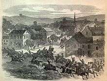
In July 1863, Old Washington was the site of a small engagement during the course of Morgan's Raid. In the course of their campaign through Ohio, the Confederate raiders appeared in several Guernsey County villages, including Old Washington, where they wreaked havoc before being caught by Union cavalry. The three Confederate dead are buried at the cemetery in Old Washington.[8]
Geography
Old Washington is located at 40°2′14″N 81°26′27″W / 40.03722°N 81.44083°W (40.037302, -81.440827).[9]
According to the United States Census Bureau, the village has a total area of 0.67 square miles (1.74 km2), all land.[1]
Demographics
| Historical population | |||
|---|---|---|---|
| Census | Pop. | %± | |
| 1820 | 161 | — | |
| 1830 | 372 | 131.1% | |
| 1850 | 759 | — | |
| 1860 | 741 | −2.4% | |
| 1870 | 554 | −25.2% | |
| 1880 | 600 | 8.3% | |
| 1890 | 546 | −9.0% | |
| 1900 | 374 | −31.5% | |
| 1910 | 366 | −2.1% | |
| 1920 | 383 | 4.6% | |
| 1930 | 336 | −12.3% | |
| 1940 | 297 | −11.6% | |
| 1950 | 322 | 8.4% | |
| 1960 | 369 | 14.6% | |
| 1970 | 346 | −6.2% | |
| 1980 | 279 | −19.4% | |
| 1990 | 281 | 0.7% | |
| 2000 | 265 | −5.7% | |
| 2010 | 279 | 5.3% | |
| Est. 2015 | 275 | [10] | −1.4% |
2010 census
As of the census[3] of 2010, there were 279 people, 111 households, and 86 families residing in the village. The population density was 416.4 inhabitants per square mile (160.8/km2). There were 119 housing units at an average density of 177.6 per square mile (68.6/km2). The racial makeup of the village was 98.9% White, 0.4% Native American, and 0.7% from two or more races. Hispanic or Latino of any race were 1.4% of the population.
There were 111 households of which 27.9% had children under the age of 18 living with them, 62.2% were married couples living together, 10.8% had a female householder with no husband present, 4.5% had a male householder with no wife present, and 22.5% were non-families. 18.9% of all households were made up of individuals and 10.8% had someone living alone who was 65 years of age or older. The average household size was 2.51 and the average family size was 2.80.
The median age in the village was 40.1 years. 21.9% of residents were under the age of 18; 8.3% were between the ages of 18 and 24; 26.3% were from 25 to 44; 24% were from 45 to 64; and 19.7% were 65 years of age or older. The gender makeup of the village was 52.3% male and 47.7% female.
2000 census
As of the census[5] of 2000, there were 265 people, 112 households, and 82 families residing in the village. The population density was 403.2 people per square mile (155.0/km²). There were 124 housing units at an average density of 188.7 per square mile (72.5/km²). The racial makeup of the village was 96.60% White, 1.89% African American and 1.51% Asian. Hispanic or Latino of any race were 0.38% of the population.
There were 112 households out of which 28.6% had children under the age of 18 living with them, 63.4% were married couples living together, 7.1% had a female householder with no husband present, and 25.9% were non-families. 24.1% of all households were made up of individuals and 12.5% had someone living alone who was 65 years of age or older. The average household size was 2.37 and the average family size was 2.78.
In the village the population was spread out with 23.4% under the age of 18, 4.5% from 18 to 24, 25.7% from 25 to 44, 27.9% from 45 to 64, and 18.5% who were 65 years of age or older. The median age was 43 years. For every 100 females there were 80.3 males. For every 100 females age 18 and over, there were 82.9 males.
The median income for a household in the village was $26,250, and the median income for a family was $31,667. Males had a median income of $31,406 versus $23,125 for females. The per capita income for the village was $24,399. About 7.8% of families and 13.9% of the population were below the poverty line, including 23.1% of those under the age of eighteen and 21.3% of those sixty five or over.
Schools
Old Washington is within the East Guernsey Local School District. Students within the village would attend Buckeye Trail High School. , Buckeye Trail Middle School and Buckeye Trail Elementary School.
References
- 1 2 "US Gazetteer files 2010". United States Census Bureau. Retrieved 2013-01-06.
- 1 2 "US Board on Geographic Names". United States Geological Survey. 2007-10-25. Retrieved 2008-01-31.
- 1 2 "American FactFinder". United States Census Bureau. Retrieved 2013-01-06.
- ↑ "Population Estimates". United States Census Bureau. Retrieved 2013-06-17.
- 1 2 "American FactFinder". United States Census Bureau. Retrieved 2008-01-31.
- ↑ Sarchet, Cyrus Parkinson Beatty (1911). History of Guernsey County, Ohio, Volume 1. B.F. Bowen & Company. p. 344.
- ↑ Overman, William Daniel (1958). Ohio Town Names. Akron, OH: Atlantic Press. p. 104.
- ↑ Russell Booth, Jr., A Brief History of Guernsey County, Guernsey County, 2008. Accessed 2009-02-06.
- ↑ "US Gazetteer files: 2010, 2000, and 1990". United States Census Bureau. 2011-02-12. Retrieved 2011-04-23.
- ↑ "Annual Estimates of the Resident Population for Incorporated Places: April 1, 2010 to July 1, 2015". Retrieved July 2, 2016.
- ↑ "Census of Population and Housing". Census.gov. Retrieved June 4, 2015.
Municipalities and communities of Guernsey County, Ohio, United States | ||
|---|---|---|
| City | 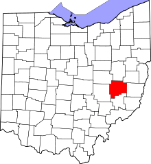 | |
| Villages | ||
| Townships | ||
| CDPs | ||
| Unincorporated communities | ||
| Footnotes | ‡This populated place also has portions in an adjacent county or counties | |