Ohio State Route 274
| ||||
|---|---|---|---|---|
 | ||||
| Route information | ||||
| Maintained by ODOT | ||||
| Length: | 52.73 mi[1] (84.86 km) | |||
| Existed: | 1930 – present | |||
| Major junctions | ||||
| West end: |
| |||
|
| ||||
| East end: |
| |||
| Location | ||||
| Counties: | Mercer, Auglaize, Shelby, Logan | |||
| Highway system | ||||
| ||||


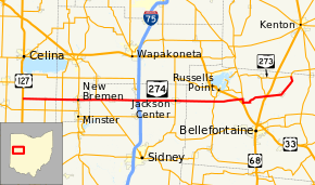
State Route 274 (SR 274) is a two-lane east–west state highway located in the western portion of the U.S. state of Ohio. The western terminus of State Route 274 is at a T-intersection with U.S. Route 127 approximately 4 miles (6.4 km) west of Chickasaw. Its eastern terminus is at another T-intersection, this time with State Route 273 about 3.5 miles (5.6 km) northeast of Rushsylvania.
Route description
State Route 274 traverses portions of Auglaize, Mercer, Shelby and Logan Counties. No portion of State Route 274 is included within the National Highway System, a system of highways determined to be most important for the economy, mobility and defense of the nation.[2]
History
State Route 274 was designated in 1930. It was originally routed between State Route 66 in New Bremen and what was originally designated State Route 69 (now State Route 235) near Russells Point.[3][4] In 1937, the highway was extended on both ends, on the west to its current western terminus at U.S. Route 127 west of Chickasaw, and on the east to its current eastern endpoint at State Route 273 northeast of Rushsylvania.[5][6]
Major intersections
| County | Location | mi[1] | km | Destinations | Notes |
|---|---|---|---|---|---|
| Mercer | Marion Township | 0.00 | 0.00 | ||
| Chickasaw | 4.12 | 6.63 | Northern terminus of SR 716 | ||
| Auglaize | German Township | 7.29 | 11.73 | ||
| New Bremen | 10.09 | 16.24 | |||
| Shelby | Van Buren Township | 13.46 | 21.66 | Western end of SR 29 concurrency | |
| 14.30 | 23.01 | Eastern end of SR 29 concurrency | |||
| Dinsmore Township | 21.24 | 34.18 | Exit 102 (I-75) | ||
| Jackson Center | 28.08 | 45.19 | |||
| Logan | Washington Township | 35.12 | 56.52 | ||
| McArthur Township | 39.67 | 63.84 | |||
| Huntsville | 40.39 | 65.00 | Western end of SR 117 concurrency | ||
| 41.09 | 66.13 | Eastern end of SR 117 concurrency | |||
| McArthur Township | 45.68 | 73.51 | |||
| 45.87 | 73.82 | ||||
| Rushcreek Township | 52.73 | 84.86 | |||
1.000 mi = 1.609 km; 1.000 km = 0.621 mi
| |||||
References
- 1 2 Ohio Department of Transportation. "Technical Services Straight Line Diagrams". Retrieved 2010-09-28.
- ↑ National Highway System: Ohio (PDF) (Map). Federal Highway Administration. December 2003. Retrieved 2010-09-28.
- ↑ Ohio State Map (Map). Ohio Department of Transportation. 1929.
- ↑ Ohio State Map (Map). Ohio Department of Transportation. 1930.
- ↑ Ohio State Map (Map). Ohio Department of Transportation. 1936.
- ↑ Ohio State Map (Map). Ohio Department of Transportation. 1937.