Ohio State Route 54
| ||||
|---|---|---|---|---|
 | ||||
| Route information | ||||
| Maintained by ODOT | ||||
| Length: | 23.79 mi[1] (38.29 km) | |||
| Existed: | 1938 – present | |||
| Major junctions | ||||
| South end: |
| |||
|
| ||||
| North end: |
| |||
| Location | ||||
| Counties: | Clark, Champaign | |||
| Highway system | ||||
| ||||

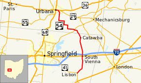
State Route 54 (SR 54) is a north–south state highway that serves west-central Ohio. It extends from Urbana in the north, to southeast of Springfield.
History
SR 54 was commissioned in 1923 between its current southern terminus and Indiana state line northwest of Willshire. The highway was routed on to mostly the current alignment of SR 29 and US 33, and its current alignment.[2][3] In 1938 the northern terminus was moved to the Indiana state line west of Celina.[4][5] One year later SR 54 between Urbana and Indiana state line became SR 29, leaving SR 54 on its current alignment.[5][6]
Major intersections
| County | Location | mi[1] | km | Destinations | Notes |
|---|---|---|---|---|---|
| Clark | Harmony Township | 0.00 | 0.00 | ||
| South Vienna | 5.25 | 8.45 | |||
| 5.67 | 9.12 | Exit 66 (I-70) | |||
| Champaign | Union Township | 13.47 | 21.68 | ||
| Urbana | 23.00 | 37.01 | Eastern end of US 36 and SR 29 concurrency | ||
| 23.79 | 38.29 | Western end of US 36 and SR 29 concurrency; eastern terminus of SR 55 | |||
1.000 mi = 1.609 km; 1.000 km = 0.621 mi
| |||||
References
- 1 2 Ohio Department of Transportation. "Technical Services Straight Line Diagrams".
- ↑ Ohio Department of Highways and Public Works (April 1922). Map of Ohio State Highways (MrSID) (Map). Columbus: Ohio Department of Highways and Public Works. Retrieved October 26, 2013.
- ↑ Ohio Department of Highways and Public Works (July 1923). Map of Ohio Showing State Routes (MrSID) (Map). 1:760,320. Columbus: Ohio Department of Highways and Public Works. Retrieved October 26, 2013.
- ↑ Ohio Department of Highways (1937). Official Highway Map of Ohio (MrSID) (Map). 1:633,600. Columbus: Ohio Department of Highways. OCLC 5673562, 16960304. Retrieved October 26, 2013.
- 1 2 Ohio Department of Highways (1938). Official Highway Map of Ohio (MrSID) (Map). 1:633,600. Columbus: Ohio Department of Highways. OCLC 5673562, 7453129. Retrieved October 26, 2013.
- ↑ Ohio Department of Highways (1939). Official Highway Map of Ohio (MrSID) (Map). 1:633,600. Columbus: Ohio Department of Highways. OCLC 5673562, 7408341. Retrieved October 26, 2013.
This article is issued from Wikipedia - version of the 6/2/2016. The text is available under the Creative Commons Attribution/Share Alike but additional terms may apply for the media files.