Onslow County, North Carolina
| Onslow County, North Carolina | ||
|---|---|---|
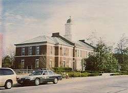 The 1904 Onslow County Courthouse | ||
| ||
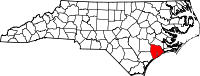 Location in the U.S. state of North Carolina | ||
 North Carolina's location in the U.S. | ||
| Founded | 1739 | |
| Named for | Arthur Onslow | |
| Seat | Jacksonville | |
| Largest city | Jacksonville | |
| Area | ||
| • Total | 906 sq mi (2,347 km2) | |
| • Land | 763 sq mi (1,976 km2) | |
| • Water | 143 sq mi (370 km2), 16% | |
| Population | ||
| • (2010) | 177,772 | |
| • Density | 233/sq mi (90/km²) | |
| Congressional district | 3rd | |
| Time zone | Eastern: UTC-5/-4 | |
| Website |
www | |

Onslow County is a county located in the U.S. state of North Carolina. As of the 2010 census, the population was 177,772.[1] Its county seat is Jacksonville.[2] The county was created in 1734 as Onslow Precinct and gained county status in 1739.[3]
Onslow County comprises the Jacksonville, NC Metropolitan Statistical Area. The southern border is the coast of the Atlantic Ocean.
History
European and English settlers arrived here in 1713 in what was originally part of the colonial precincts of Carteret and New Hanover. Onslow County was formed in 1734 and was named for the Honorable Arthur Onslow, the longest serving Speaker of the British House of Commons. After a lethal 1752 hurricane, the county courthouse was relocated from Town Point to Wantland’s Ferry; this settlement was eventually incorporated in 1842 and named Jacksonville after President Andrew Jackson. Through much of the first half of the 20th century, the county was largely rural, with an economy based on agrarian and maritime communities.
During World War II, Onslow County was dramatically changed in the early 1940s with the establishment of the United States Army Camp Davis near Holly Ridge (now defunct), and the creation of Camp Lejeune in 1941. This increased county population and generated related growth in housing and businesses.
Onslow County’s flat, rolling terrain covers 767 square miles (1,990 km2) and is located in the southeastern coastal plain of North Carolina, approximately 120 miles (190 km) east of Raleigh and 50 miles (80 km) north of Wilmington. The city of Jacksonville is the county seat, and the areas surrounding the city constitute the major population centers and growth areas in the county. The county is home to more than 150,000 people and includes the incorporated towns of Holly Ridge, Richlands, Swansboro, North Topsail Beach, part of Surf City, and unincorporated Sneads Ferry. The U.S. Marine Corps Base, Camp Lejeune comprises approximately 156,000 acres (630 km2); more than 43,000 marines and sailors are stationed there. The two "nations" of PLCC and Ridgeweia are also located within Holly ridge and Sneads Ferry.
Geography
According to the U.S. Census Bureau, the county has a total area of 906 square miles (2,350 km2), of which 763 square miles (1,980 km2) is land and 143 square miles (370 km2) (16%) is water.[4]
Adjacent counties
- Jones County - north
- Carteret County - east
- Pender County - southwest
- Duplin County - northwest
Demographics
| Historical population | |||
|---|---|---|---|
| Census | Pop. | %± | |
| 1790 | 5,387 | — | |
| 1800 | 5,623 | 4.4% | |
| 1810 | 6,669 | 18.6% | |
| 1820 | 7,016 | 5.2% | |
| 1830 | 7,814 | 11.4% | |
| 1840 | 7,527 | −3.7% | |
| 1850 | 8,283 | 10.0% | |
| 1860 | 8,856 | 6.9% | |
| 1870 | 7,569 | −14.5% | |
| 1880 | 9,829 | 29.9% | |
| 1890 | 10,303 | 4.8% | |
| 1900 | 11,940 | 15.9% | |
| 1910 | 14,125 | 18.3% | |
| 1920 | 14,703 | 4.1% | |
| 1930 | 15,289 | 4.0% | |
| 1940 | 17,939 | 17.3% | |
| 1950 | 42,047 | 134.4% | |
| 1960 | 82,706 | 96.7% | |
| 1970 | 103,126 | 24.7% | |
| 1980 | 112,784 | 9.4% | |
| 1990 | 149,838 | 32.9% | |
| 2000 | 150,355 | 0.3% | |
| 2010 | 177,772 | 18.2% | |
| Est. 2015 | 186,311 | [5] | 4.8% |
| U.S. Decennial Census[6] 1790-1960[7] 1900-1990[8] 1990-2000[9] 2010-2013[1] | |||
As of the census[10] of 2000, there were 150,355 people, 48,122 households, and 36,572 families residing in the county. The population density was 196 people per square mile (76/km²). There were 55,726 housing units at an average density of 73 per square mile (28/km²). The racial makeup of the county was 72.06% White, 18.48% Black or African American, 0.74% Native American, 1.68% Asian, 0.19% Pacific Islander, 3.62% from other races, and 3.22% from two or more races. 7.25% of the population were Hispanic or Latino of any race.
There were 48,122 households out of which 42.60% had children under the age of 18 living with them, 61.00% were married couples living together, 11.60% had a female householder with no husband present, and 24.00% were non-families. 18.60% of all households were made up of individuals and 5.20% had someone living alone who was 65 years of age or older. The average household size was 2.72 and the average family size was 3.09.
In the county the population was spread out with 26.20% under the age of 18, 23.80% from 18 to 24, 29.20% from 25 to 44, 14.40% from 45 to 64, and 6.30% who were 65 years of age or older. The median age was 25 years. For every 100 females there were 123.20 males. For every 100 females age 18 and over, there were 131.30 males.
The median income for a household in the county was $33,756, and the median income for a family was $36,692. Males had a median income of $22,061 versus $20,094 for females. The per capita income for the county was $14,853. About 10.80% of families and 12.90% of the population were below the poverty line, including 16.70% of those under age 18 and 14.70% of those age 65 or over.
Law and government
The structure of local government in Onslow County was established in the late 19th century. It consists of a five-member Board of Commissioners, all elected at-large for four-year terms. In contrast to electing members from districts, this structure means that candidates are elected by the majority population in the county, which gives a more accurate view of the entire electorate. The Board establishes policies and ordinances implemented by the County Manager and his staff. Commissioners are, Barbara M. Ikner (Chair), Paul Buchanan (Vice-Chair), Jack Bright, Million Heir-Williams, and W.C. Jarman.
The main law enforcement agency for Onslow County is the County Sheriff's Department. The elected sheriff is Hans Miller.
Onslow County is a member of the regional Eastern Carolina Council of Governments.
Transportation
Major highways
Airport
The Albert J. Ellis Airport is located near Richlands and is served by two commercial airlines.
Communities
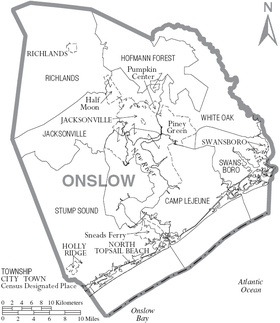
City
- Jacksonville (county seat)
Towns
Census-designated places
Townships
- Jacksonville
- Richlands
- Sneads Ferry
- Southwest
- Swansboro
- White Oak
See also
References
- 1 2 "State & County QuickFacts". United States Census https://m.facebook.com/profile.php?id=109314395755079&refid=17 27, 2013. External link in
|publisher=(help) - ↑ "Find a County". National Association of Counties. Retrieved 2011-06-07.
- ↑ "North Carolina: Individual County Chronologies". North Carolina Atlas of Historical County Boundaries. The Newberry Library. 2009. Retrieved January 25, 2015.
- ↑ "2010 Census Gazetteer Files". United States Census Bureau. August 22, 2012. Retrieved January 18, 2015.
- ↑ "County Totals Dataset: Population, Population Change and Estimated Components of Population Change: April 1, 2010 to July 1, 2015". Retrieved July 2, 2016.
- ↑ "U.S. Decennial Census". United States Census Bureau. Retrieved January 18, 2015.
- ↑ "Historical Census Browser". University of Virginia Library. Retrieved January 18, 2015.
- ↑ Forstall, Richard L., ed. (March 27, 1995). "Population of Counties by Decennial Census: 1900 to 1990". United States Census Bureau. Retrieved January 18, 2015.
- ↑ "Census 2000 PHC-T-4. Ranking Tables for Counties: 1990 and 2000" (PDF). United States Census Bureau. April 2, 2001. Retrieved January 18, 2015.
- ↑ "American FactFinder". United States Census Bureau. Retrieved 2008-01-31.
External links
- Official website
- NCGenWeb Onslow County - free genealogy resources for the county
- Onslow County Schools
- Onslow County Museum
 |
Duplin County | Jones County | | |
| |
Carteret County | |||
| ||||
| | ||||
| Pender County | Atlantic Ocean |
Municipalities and communities of Onslow County, North Carolina, United States | ||
|---|---|---|
| City |  | |
| Towns | ||
| CDPs | ||
| Unincorporated communities | ||
| Military bases | ||
| Footnotes | ‡This populated place also has portions in an adjacent county or counties | |
Coordinates: 34°43′N 77°25′W / 34.71°N 77.41°W