Ontario Highway 20
| ||||
|---|---|---|---|---|
| Lundy's Lane | ||||
| Route information | ||||
| Maintained by the Ministry of Transportation | ||||
| Length: | 1.9 km[1] (1.2 mi) | |||
| Existed: | March 12, 1930,[2] – present | |||
| Major junctions | ||||
| West end: |
| |||
| East end: |
| |||
| Location | ||||
| Major cities: | Thorold, Niagara Falls | |||
| Highway system | ||||
| ||||

King's Highway 20, commonly referred to as Highway 20, is a provincially maintained highway in the Canadian province of Ontario. Presently, it is a short 1.9 km (1.2 mi) stub between Highway 58 and Niagara Regional Road 70 in the town of Thorold, but until 1997 it connected Hamilton to Niagara Falls, serving several towns atop the Niagara Escarpment en route.
Highway 20 was first designated in 1930, serving as a bypass to the congested Highway 8. Soon after, a new cut was made into the Niagara Escarpment south of Stoney Creek, which would serve Highway 20 for 66 years. However, the new route failed to divert a significant amount of traffic from Highway 8. Subsequently, the Queen Elizabeth Way (QEW) was constructed through the Niagara Peninsula between 1937 and 1940. The opening of the Burlington Bay Skyway in 1958 bypassed the routing of Highway 20; it was truncated at the QEW in Stoney Creek in 1964 as a result. The routing remained unchanged between then and 1998, when all but a short stub of the highway was transferred to regional jurisdiction.
Route description
While today Highway 20 is a mere 1.9-kilometre (1.2 mi) stub of its former length, most of the former route retains the same layout and character as the highway did prior to 1998, serving as the main street of the villages of Fonthill and Smithville.[3] At Allanburg, Highway 20 crosses the Welland Canal utilizing the Allanburg Bridge, or Bridge 11, a vertical lift bridge which opened to traffic in the spring of 1930 shortly after hwy 20 was first opened.
The remaining portion of the highway is mostly rural in nature, although numerous motels line the short stretch of roadway, reminiscent of a bygone era. It begins at a signalized intersection with Highway 58, which proceeds north and west from there. Moving eastward, the majority of motels line the south side of the highway, as do several residences and a strip club. At Thorold Townline Road (Regional Road 70), Highway 20 ends while the roadway continues eastward into the city of Niagara Falls as Lundy's Lane.
Lundy's Lane is named for William Lundy, a United Empire Loyalist and local settler in the Niagara area. During the 1960s and 1970s, Lundy's Lane attracted a concentration of businesses which catered to automobile travellers and tourists. However, a significant number of these businesses faded away along with the automobile age.
History
Highway 20 was first designated on March 12, 1930,[2] with its western terminus at the intersection of Highway 8 (Main Street) and Highway 6 (John Street) in downtown Hamilton. It proceeded south along John Street, concurrently with Highway 6, to the foot of the Niagara Escarpment, where the two routes split. Highway 20 climbed the escarpment through the Jolley Cut, while Highway 6 used the Claremont Access. At the top, Highway 20 proceeded east along Concession Street, then south along Upper Gage Avenue to Rymal Road. From there, the route turned east and followed Rymal Road to Elfrida and onwards to its eastern terminus at the Honeymoon Bridge Niagara Falls.[4][5][6]
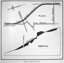
Soon thereafter, the Department of Highways (DHO) began to excavate a new cut into the escarpment between Elfrida and Stoney Creek. While under construction in 1931, Highway 20 was rerouted onto what would become known as Centennial Parkway, briefly ending at a junction between Highway 8 and Highway 8A (the present day intersection of Queenston Road and Centennial Parkway); the old routing from Elfrida to downtown Hamilton was renumbered as Highway 20A.[7] The highway descended the escarpment along the now-closed Glover Mountain Road, which connected the modern Greenhill Avenue with First Road. Highway 8A meanwhile, proceeded north from Stoney Creek to Burlington via Burlington Beach; it was renumbered as an extension of Highway 20 when the Stoney Creek Cut was completed in 1932. At the same time, the highway was shifted from Glover Mountain Road to the new Centennial Parkway.[8]
Between Welland and Niagara Falls, Highway 3 originally followed the Merrittville Highway (later Highway 58) and Lundy's Lane to the Honeymoon Bridge; Highway 3A connected Port Colborne to Fort Erie. In 1929, the two route numbers were switched,[9] as traffic pattern had shifted to make use of the new Peace Bridge.[10] After Highway 20 was designated, the Highway 3A designation was superseded between Allanburg and Niagara Falls.[7]
Between Hamilton and Welland, several major diversions were constructed during the 1930s, including west of Elfrida (the old route followed South Townline Road and Chapel Hill Road), east of Kimbo (the old route now known as Kimbo Road) and around St. Anns (having originally followed Twenty Mile Creek Road and St. Anns Road). In 1938, construction began on a large traffic circle between Highway 20 and the QEW in Stoney Creek and on a cloverleaf with Lundy's Lane in Niagara Falls; both were completed prior to the opening of the QEW on August 23, 1940. Highway 20 was now 85.8 km (53.3 mi), its peak length.
Both the QEW and Highway 20 crossed the entrance to Hamilton Harbour utilizing a four lane lift bridge. However, this quickly became one of the two major bottlenecks along the new superhighway. By the early-1950s, traffic lineups often stretched for several kilometres each time the bridge raised. This prompted the DHO to construct a skyway over the canal, which opened on October 30, 1958 and provided four lanes of uninterrupted travel.[11] Subsequently, the use of Highway 20 (now Beach Boulevard) for long distance travel ceased. In 1964, the portion of Highway 20 between Burlington and the Stoney Creek Traffic Circle was transferred to Halton County and Wentworth County, reducing its length to 74.2 kilometres (46.1 mi).
The route remained unchanged until the late 1990s. On January 1, 1998, the province downloaded the majority of the highway to the Regional Municipalities of Hamilton and Niagara. However, a short section remains, connecting Highway 58 to the city boundary of Niagara Falls. It is unclear why this short portion was retained in the provincial highway network.
Major intersections
The following table lists the major junctions along Highway 20, as noted by the Ministry of Transportation of Ontario.[1] The entire route is located in the Regional Municipality of Niagara.[3]
| Location | km[1] | mi | Destinations | Notes | |
|---|---|---|---|---|---|
| Allanburg | 0.0 | 0.0 | |||
| Thorold | 1.9 | 1.2 | |||
| Niagara Falls | 6.1 | 3.8 | Beaver Dams Road | ||
| 6.3 | 3.9 | Montrose Avenue | |||
| 6.6 | 4.1 | ||||
| 7.2 | 4.5 | Dorchester Road | |||
| 8.2 | 5.1 | Drummond Road | |||
| 9.3 | 5.8 | Stanley Avenue | |||
| 10.5 | 6.5 | Falls Avenue | Rainbow Bridge to USA | ||
1.000 mi = 1.609 km; 1.000 km = 0.621 mi
| |||||
References
- Sources
- 1 2 3 Ministry of Transportation of Ontario (2008). "Annual Average Daily Traffic (AADT) counts". Retrieved February 8, 2012.
- 1 2 "Appendix 5 - Schedule of Assumptions and Reversions". Annual Report (Report). Department of Highways. March 31, 1931. p. 76.
- 1 2 Ontario Back Road Atlas (Map). Cartography by MapArt. Peter Heiler. 2010. p. 19. § S34. ISBN 978-1-55198-226-7.
- ↑ "System of the King's Highways". Annual Report (Report). Department of Highways. March 31, 1931. p. 14.
- ↑ Ontario Road Map (Map). Cartography by D. Barclay. Ontario Department of Highways. 1931–32. Hamilton inset. Retrieved May 28, 2012.
- ↑ Ontario Road Map (Map). Cartography by C.P. Robins. Ontario Department of Highways. 1938–39. § L–M9.
- 1 2 "System of the King's Highways". Annual Report (Report). Department of Highways. March 31, 1932. p. 14.
- ↑ "Hamilton Division - Construction". Annual Report (Report). Department of Highways. March 31, 1931.
- ↑ "System of the King's Highways". Annual Report (Report). Department of Highways. March 31, 1930. p. 14.
- ↑ Stamp 1987, p. 37.
- ↑ Stamp & 87, p. 59.
- Bibliography
- Stamp, Robert M. (1987). QEW – Canada's First Superhighway. The Boston Mills Press. ISBN 0-919783-84-8.