Ontario Highway 69
| |||||||||||||
|---|---|---|---|---|---|---|---|---|---|---|---|---|---|
| Trans-Canada Highway | |||||||||||||
| Route information | |||||||||||||
| Maintained by The Ministry of Transportation of Ontario | |||||||||||||
| Length: | 162 km[1] (101 mi) | ||||||||||||
| Existed: | August 5, 1936[2] – present | ||||||||||||
| Major junctions | |||||||||||||
| South end: |
| ||||||||||||
| North end: |
| ||||||||||||
| Highway system | |||||||||||||
| |||||||||||||
King's Highway 69, commonly referred to as Highway 69, is a major north–south highway in the central portion of the Canadian province of Ontario, linking Highway 400 north of Parry Sound with the city of Greater Sudbury at Highway 17.
From its northerly terminus at Sudbury, the highway follows a wide urban arterial route for several kilometres before widening into a full freeway south of Crown Ridge. As of July 2016 this freeway segment extends south 49 km to a point 2 km north of Highway 607. From there, the route narrows to a two-lane highway to its southerly terminus, located three kilometres north of Highway 559 at Carling. At this terminus, the roadway widens to four lanes and changes its designation to Highway 400. South of this point, various former alignments of Highway 69 remain in use as parts of Highway 400 or as county or local roads. The highway forms part of the Central Ontario route of the Trans-Canada Highway, which continues south along Highway 400.
Highway 69 was first designated in 1936 when the Department of Highways (DHO) assumed the Rama Road between Atherley and Washago. This short route was expanded the following year when the DHO merged with the Department of Northern Development and expanded the King's Highway network north of the Severn River. By the beginning of World War II, the route reached as far north as Britt; a separate segment connected the town of Burwash with Sudbury. However, the rationalization of labour and materials due to the war effort resulted in these two sections remaining separated until the mid-1950s.
In 1976, several reroutings and renumbering took place in the Muskoka area. As a result, the portion of Highway 69 between Brechin and Foot's Bay was renumbered as Highway 169, while the entirety of Highway 103 between Coldwater and Foot's Bay was renumbered as Highway 69. Until the 1980s, the highway extended through Sudbury to Capreol, but was then truncated at a junction with Highway 17's route through Sudbury along what is now Municipal Road 55; this portion was subsequently truncated again in 1995 upon the completion of the Southwest and Southeast Bypasses, onto which Highway 17 was rerouted. Throughout the 1990s and 2000s, Highway 400 was gradually pushed north to its current terminus by twinning Highway 69, gradually truncating the southern end of the Highway 69 route.
Route description
Highway 69 is a major highway serving the recreational areas surrounding Georgian Bay and the Thirty-Thousand Islands, as well as providing the westernmost fixed connection between southern and northern Ontario; Highway 6 is located further west but requires the use of a ferry service. The highway occupies the northern half of a corridor that connects to Toronto to Sudbury, with Highway 400 occupying the southern half. The route forms part of the Central Ontario route of the Trans-Canada Highway.
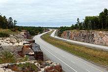
As of 2012, the highway begins just north of Exit 241 (Highway 559) on Highway 400. From here the route travels generally northward. Between Nobel and Sudbury, there are no large communities, although numerous small communities lie adjacent to the route, including Shawanaga, Pointe au Baril, Byng Inlet, Britt, Bigwood, Delamere and Estaire. South of Highway 637, the highway widens into a four-lane freeway extending most of the remaining distance to Sudbury, where the divided highway ends just south of Crown Ridge; from this point until the highway's final terminus in Sudbury, it remains a four-lane urban arterial road with a paved, rather than fully separated, median between the two carriageways.
The highway ends at an interchange with Highway 17 in Sudbury. North of the interchange, the roadway continues north into the urban core of Sudbury as Regent Street/Municipal Road 46.
History
Highway 69 has undergone several major changes during its existence, so much so that the first section designated has not been a King's Highway for 60 years and lay approximately 80 km (50 mi) from the current highway. In other places, a minor two lane gravel highway has gradually been upgraded to a four lane paved freeway. On August 5, 1936, the DHO assumed the Rama Road, connecting Highway 12 at Atherley with Highway 11 at Washago.[2] On March 31, 1937, the Department of Northern Development (DND) was merged into the DHO, allowing the latter to extend the provincial highway network north of the Severn River. Subsequently, through August 1937, Highway 69 was extended 77.75 mi (125.13 km) north to the Naiscoot River, midway between Pointe au Baril and Britt. This extension followed DND trunk routes to Nobel, where a munitions and aircraft factory would soon provide an instrumental role in the war effort. In the north, the road connecting Sudbury and Burwash was also assumed as Highway 69 on August 11. It was intended to connect these two segments over the next several years; however, the outbreak of World War II in September 1939 halted all non-essential construction due to the short supply of labour and materials.
Work resumed during the 1950s to bridge the 60 km (37 mi) gap between the two sections of highway. In 1954, a further 29 km (18 mi) of roadway north of Britt was assumed as Highway 69. That same year also saw the rerouting of the southern end of the highway; the southern end was moved east from Atherley to Brechin and the Rama Road decommissioned as a King's Highway. The new routing was longer, but gave the southern end of the highway a more significant purpose than as a bypass of Highway 11. The Rama Road has since been known as Simcoe County Road 44.
Once the war ended, construction resumed on Highway 69. Paving and extending the road continued, with the first gap (between Britt and Burwash) being closed in 1951. French River would be linked to the provincial roadway network in 1952. This allowed motorists to take a far more direct route between Severn River and Sudbury, by taking advantage of a detour (via Highway 535 and Highway 64, through the small communities of Hagar and Noëlville).
The biggest gap that remained on Highway 69 was between Alban and Burwash, but this was eventually eliminated from 1952 to 1955, when the road was finally completed to provide a third link from Southern Ontario to Northern Ontario (the other two being Highways 11 and 17).
Until Highway 69 between Parry Sound and Sudbury was completed, drivers from Southern Ontario who wanted to reach Sudbury or Sault Ste. Marie had to travel along a rather out-of-the-way routing on Highway 11 to North Bay, and then take Highway 17 westbound into Sudbury and Sault Ste. Marie.
The year 1976 saw big changes for Highway 69. The portion of highway south of MacTier was shifted onto the routing of former Highway 103, completely absorbing that roadway into its length. The former routing was renamed Highway 169. It was at this time that Highway 69 was at its longest, from Highways 12 and 400 near Port Severn to Sudbury.
Until the early 1980s, Highway 69 continued through Sudbury and into the suburban towns of Valley East and Capreol. Although this route is no longer part of the provincial highway, and is officially designated as a series of Sudbury Municipal Roads, it is referred to locally by some as "Highway 69 North".
Since 1989, Highway 400 has been extended gradually northward towards Sudbury, and now reaches Nobel.
From 2008 to 2012, however, the Highway 69 designation continued to a southerly terminus at MacTier, rather than Nobel — the two highways shared a routing for 32 kilometres between Nobel and Rankin Lake Road, and then followed separate routes between Rankin Lake Road and Highway 69's southern terminus near MacTier. Signs were posted along this route announcing that the segment from Rankin Lake Road to Mactier would be decommissioned as part of Highway 69 in summer 2012.[3] The route's posted name is now Lake Joseph Road, although it remains part of the provincial highway system under an unsigned 7000-series designation.
Four-laning
Although early planning for an eventual four-lane highway started in 1969, the commitment to expand Highway 69 to a full freeway was originally made in 1991 by the New Democrat government of Bob Rae.[4] Although construction did commence northward from Waubaushene at the highway's southern end, and planning studies were underway on the first 65 kilometres southward from Sudbury,[5] the project was curtailed by the Progressive Conservative government of Mike Harris shortly after the 1995 provincial election,[5] with construction ending at kilometre 225 in Parry Sound.[4]
The city of Sudbury continued to lobby for the highway's expansion, calling attention especially to an ongoing series of fatal car accidents at the intersection of Highway 637, where a sharp S-curve in Highway 69's route rendered the approaching intersection effectively invisible to northbound traffic.[4] Assisted by Rick Bartolucci, the Liberal MPP for Sudbury, the CRASH 69 (Community Rallying Against Substandard Highway 69) committee of Sudbury residents campaigned throughout the late 1990s and early 2000s to have the project reinstated.[4] The revived construction to Sudbury was announced in 2002 by Harris' successor (and former MPP for Parry Sound—Muskoka), Ernie Eves.[4]
In 2004, construction began on the segment from Sudbury southwards to Estaire, and route planning studies were completed for the Estaire to Parry Sound branch. Although the timetable has been subject to change, the four-laned route was scheduled to be completed in its entirety by 2017. Portions of the route will be opened to traffic as construction is completed — the 20 kilometre section south of Sudbury from Crown Ridge to Estaire was opened for traffic on November 12, 2009,[6] and the segment from Highway 559 to Parry Sound opened to traffic on October 26, 2010.[7] The former alignment in Sudbury now has the street name Estaire Road, while the former route through Nobel now has the street name Nobel Drive.
Work has also now been completed on a realignment of the controversial S-curve at Highway 637. Construction began on the new four-lane route at this location in 2008. Two lanes opened to traffic on July 27, 2010,[8] and the completed four-lane route with a full highway interchange at Highway 637 opened to traffic on August 8, 2012.[9] The former S-curve alignment now has the name Murdock River Road, and is accessible only from Highway 637 as a local road.
Concurrently with the final stages of construction on Highway 69, the Highway 17 freeway in Sudbury will be extended eastward to the Coniston neighbourhood along the city's Southwest and Southeast Bypasses. In preparation for this latter project, an interchange opened in 2008 at the intersection of Highway 17 and Sudbury's Long Lake Road.
As the Highway 69 route passes through significant tracts of wilderness and forest land, the route has also historically seen a rate of animal collisions well above the provincial norm. Several segments of the four-laned freeway route will include special grade-separated wildlife crossings, the first of which was completed in March 2012.[10]
Schedule
Although the original plan called for the four-laning of the highway to be complete by 2017, delays in environmental assessment and land negotiations with First Nations bands impacted by the construction have led to the timeline being pushed back.[11] In the early 2010s, a widespread perception that the project appeared to be falling behind schedule was frequently discussed in the city's media and by candidates in municipal and provincial elections,[12] but the Ministry of Transportation continued to assert that the project was on track for completion in 2017. In March 2015, the ministry officially acknowledged for the first time that the 2017 timeline will not be met, and the target date is now between 2019 and 2021.[11]
Once the four-lane expansion project is complete, the highway will be fully renumbered as Highway 400. Northern sections will retain the 69 designation until the freeway is fully connected.
As of July 3, 2011, the federal government has delayed further work from being done on this highway while it completes a screening under the Canadian Environmental Assessment Act; although environmental assessments were already completed on individual portions of the route, a Supreme Court of Canada decision in an unrelated case, MiningWatch v. Minister of Fisheries and Oceans, created a precedent which effectively forced the federal government to rescind these approvals and reassess the project as a whole.[13] As of November 1, 2011, Transport Canada addressed a letter to the Greater Sudbury Chamber of Commerce advising that the reassessment was nearly complete.[14]
The provincial government tendered new contracts in March 2012 for the next phase of construction, from the southern limit of the current construction project near Highway 637 to just north of the French River.[15]
Status of construction activity
(Segments listed north to south)
- Completed since 2011:
- South of Estaire to slightly north of the Murdock River (13 km) - Opened August 8, 2012[9][16]
- Includes one interchange, with Highway 637[17]
- Slightly north of the Murdock River to slightly north of Highway 64 (9 km) - Completed September 11, 2015[15][16][18][19]
- Includes one interchange, with Crooked Lake Road[17]
- Slightly north of Highway 64 to slightly north of Highway 607 (11 km) - Completed Summer 2016[16][18][20]
- Includes one interchange, with Highway 64 / Daoust Lake Road[21]
- South of Estaire to slightly north of the Murdock River (13 km) - Opened August 8, 2012[9][16]
- Currently under construction:
- Slightly north of Highway 607 to slightly north of Highway 522 (14 km) - Anticipated completion in 2020[16][18][22]
- Includes two interchanges (with Highway 607 / Hartley Bay Road and Pickerel River Road) and two major bridges (over French River and Pickerel River)[21]
- Realignment of CN railway near junction with Highway 522 - Anticipated completion in 2017[23][24]
- Shifting 2.7 km of railway onto a new alignment; enables future construction of interchange with Highway 522 (included in following segment)[25]
- Slightly north of Highway 607 to slightly north of Highway 522 (14 km) - Anticipated completion in 2020[16][18][22]
- Engineering and property acquisition:
- Slightly north of Highway 522 to southern limit of Magnetawan First Nation (27 km)[16]
- Mostly on new alignment; includes three interchanges (with Highway 522, Bekanon Road and Highway 529 [North Jct.]) and bridge over Magnetawan River; crosses territory of Henvey Inlet First Nation and Magnetawan First Nation[25][26]
- Southern limit of Magnetawan First Nation to Highway 529 (South Jct.) (14 km)[16]
- Includes one interchange, with Harris Lake Road, and bridge over Naiscoot Lake[27]
- Highway 529 (South Jct.) to north side of Shawanaga River (11 km)[16]
- Includes one interchange, with Highway 529 [South Jct.] / Site 9 Rd., and bypass of Pointe au Baril[28]
- North side of Shawanaga River to slightly north of Highway 559 (16 km)[16]
- Includes two interchanges (with Shebeshekong Rd. / Site 9 Rd. and Woods Rd.); crosses territory of Shawanaga First Nation[29]
- Slightly north of Highway 522 to southern limit of Magnetawan First Nation (27 km)[16]
Former segments
Due to the many realignments and modifications that have taken place throughout Highway 69's history, numerous roads which were formerly part of the route of Highway 69 are now in use as parts of other highways or as county or local roads. This includes much of the routing of Highway 400 between Waubaushene and Nobel, Highway 529, the former Highway 169 and the following local roads:
- Lone Pine Road, White Falls Road and Joe King's Road in Georgian Bay
- Lake Joseph Road in Georgian Bay and Seguin
- Oastler Park Drive, Louisa Street and Parry Sound Drive in Parry Sound
- Nobel Road in Nobel
- Murdock River Road, Burwash Road, Estaire Road and Secord Road in Sudbury District
- Estaire Road, Secord Road, Old Wanup Road, Bentley Avenue, Old Burwash Road, Algonquin Road and Municipal Roads 46, 80 and 84 in Sudbury
Some of these routes remain as part of the provincial highway system under unsigned 7000-series designations.
Major intersections
The following table lists the major junctions along Highway 69, as noted by the Ministry of Transportation of Ontario.[30]
| Division | Location | km[30] | mi | Exit | Destinations | Notes |
|---|---|---|---|---|---|---|
| Muskoka|District Municipality of Muskoka|Muskoka | Georgian Bay | −58.2 | −36.2 | – | Exit 189; terminus of Highway 69 from 2008 to 2012. | |
| −53.8 | −33.4 | – | District Road 11 – MacTier | |||
| Foot's Bay | −52.1 | −32.4 | – | District Road 169 east – Bala, Gravenhurst | Formerly Highway 169 | |
| Parry Sound | Gordon Bay | −43.0 | −26.7 | – | Highway 612 south – MacTier | |
| Seguin | – | Beginning of Highway 141 concurrency (2003 - 2012). | ||||
| −32.8 | −20.4 | – | End of Highway 141 concurrency (2003 - 2012). Terminus of Highway 141 prior to 2003. | |||
| −30.2 | −18.8 | 213 | Beginning of Highway 400 concurrency (2003 - 2012). | |||
| −27.1 | −16.8 | 214 | Seguin Trail Road, Horseshoe Lake Road | |||
| −23.9 | −14.9 | 217 | Oastler Park Drive, Badger Road | Prior to 2003, Oastler Park Drive was the alignment of Highway 69. | ||
| −20.5 | −12.7 | 220 | ||||
| Parry Sound | −16.9 | −10.5 | 224 | Bowes Street, McDougall Road | ||
| −14.4 | −8.9 | 229 | Parry Sound Drive | Parry Sound Drive is a former alignment of Highway 69. | ||
| McDougall | −11.8 | −7.3 | 231 | |||
| −6.7 | −4.2 | 237 | Avro Arrow Road — Nobel | |||
| −1.3 | −0.81 | 241 | ||||
| Carling | 0.0 | 0.0 | ||||
| 17.2 | 10.7 | – | Shebeshekong Road | Unsigned Highway 7182 | ||
| Pointe Au Baril | 26.4 | 16.4 | – | |||
| The Archipelago | 28.3 | 17.6 | – | |||
| Magnetawan First Nation | 48.3 | 30.0 | – | |||
| Henvey | 53.5 | 33.2 | – | |||
| Cranberry | 66.3 | 41.2 | – | |||
| Bon Air | 78.6 | 48.8 | – | |||
| Sudbury | ||||||
| Bigwood | 80.9 | 50.3 | – | Highway 607 | ||
| Rutter | 90.3 | 56.1 | – | Grade-separated interchange completed 2016 | ||
| Unorganized Sudbury District | 102.0 | 63.4 | – | Crooked Lake Road | Grade-separated interchange completed 2015 | |
| 107.1 | 66.5 | – | Highway 637 west – Killarney | Grade-separated interchange opened August 8, 2012. | ||
| 119.1 | 74.0 | – | Nelson Road – Estaire | |||
| Greater Sudbury | 128.1 | 79.6 | – | |||
| 134.0 | 83.3 | – | Estaire Road | Estaire Road is a former alignment of Highway 69. | ||
| 134.5 | 83.6 | |||||
| 140.3 | 87.2 | – | Terminus of Highway 69; roadway continues northerly as Regent Street/Municipal Road 46. | |||
1.000 mi = 1.609 km; 1.000 km = 0.621 mi
| ||||||
References
- ↑ Ministry of Transportation of Ontario (2007). "Annual Average Daily Traffic (AADT) counts". Retrieved July 17, 2011.
- 1 2 A.A. Smith (March 31, 1937). "King's Highways, Ontario". Annual Report (Report). Department of Highways. p. 51.
- ↑ Cooper, Cody Storm (June 27, 2012). "Highway 69 Name Change". Huntsville Forester. Metroland Media.
- 1 2 3 4 5 "Highway 69 and 11 expansion rolling north: Northerners say safety, efficiency, new development will open up the region". Northern Ontario Business, May 1, 2008.
- 1 2 "Four-laning is on the slow track". Sudbury Star, October 3, 1999.
- ↑ "New section of 69 opens to public". Northern Life, November 13, 2009.
- ↑ "$177-million section of highway now open". CottageCountryNow.ca, October 27, 2010.
- ↑ "Bad section of Highway 69 now fixed: MPP". Sudbury Star, July 28, 2010.
- 1 2 "From tragedy to action -- more Hwy 69 4-laned 5". Sudbury Star, August 4, 2012.
- ↑ "Ontario builds first bridge for animals near Sudbury". CBC News, March 20, 2012.
- 1 2 "Highway 69 to be delayed, province admits". Sudbury Star, March 7, 2015.
- ↑ "Sudbury Accent: Highway 69 by 2017? Seems unlikely". Sudbury Star, January 3, 2015.
- ↑ "Highway 69 expansion hits an environmental roadblock". Daily Commercial News and Construction Record, February 26, 2010.
- ↑ "EA almost done: official". Sudbury Star, November 1, 2011.
- 1 2 "Highway 69 contracts up for grabs". Northern Life, March 21, 2012.
- 1 2 3 4 5 6 7 8 Key Plan: Highway 69 Four-Laning, Parry Sound to Sudbury, 152 km. Ontario Ministry of Transportation. July 2012.
- 1 2 Highway 69 Four-Laning Detail Design - Highway 64 Northerly to Estaire. AECOM.
- 1 2 3 "Ontario Continuing to Invest in Highway 69 Expansion". Ontario Ministry of Transportation, January 25, 2016.
- ↑ Highway 69 a bit wider today. The Sudbury Star.
- ↑ "Hwy 69 widening continues: Ontario unveils another 11 km for drivers". CBC Sudbury. 2016-07-15.
- 1 2 Highway 69 Four-Laning Detail Design - North of Highway 522 to North of Highway 64. MMM Group.
- ↑ MTO Contract 2015-5119
- ↑ "Ontario Government Investing $19.4 Million in Highway 69 Expansion". Ontario Ministry of Transportation, June 19, 2015.
- ↑ MTO Contract 2015-5100
- 1 2 Highway 69 Four-Laning Detail Design - Magnetawan River northerly to north of Highway 522. URS.
- ↑ Highway 69 Four-Laning Detail Design - 5.3 km south of Highway 529 (north Junction) northerly to 2.2 km north of Highway 529 (north Junction). AECOM.
- ↑ Highway 69 Four-Laning Detail Design - Highway 529 Northerly 15 km. MMM Group.
- ↑ Highway 69 Four-Laning Detail Design - Shawanaga River Northerly to Highway 529. MMM Group.
- ↑ Highway 69 Four-Laning Detail Design - Highway 559 Northerly to the Shawanaga River. MMM Group.
- 1 2 Ministry of Transportation of Ontario (2008). "Annual Average Daily Traffic (AADT) counts". Retrieved April 24, 2012.
External links
- Highway 69 at OntHighways.com
- Highway 69 Four-Laning Detail Design
- Highway 69 Expansion - engineering and design projects
| Preceded by |
Trans-Canada Highway |
Succeeded by |
| British Columbia | ||
|---|---|---|
| Alberta | ||
| Saskatchewan | ||
| Manitoba | ||
| Ontario | ||
| Quebec | ||
| New Brunswick | ||
| Prince Edward Island | ||
| Nova Scotia | ||
| Newfoundland | ||
| ||