Ottawa Islands
| Native name: <span class="nickname" ">Arviliit | |
|---|---|
| Geography | |
| Location | Hudson Bay |
| Coordinates | 59°30′N 80°25′W / 59.500°N 80.417°WCoordinates: 59°30′N 80°25′W / 59.500°N 80.417°W |
| Archipelago | Canadian Arctic Archipelago |
| Total islands | 24 |
| Major islands | Booth Island, Bronson Island, Eddy Island, Gilmour Island, J. Gordon Island, Pattee Island, Perley Island |
| Highest elevation | 549 m (1,801 ft) |
| Administration | |
| Territory | Nunavut |
| Region | Qikiqtaaluk |
| Demographics | |
| Population | Uninhabited |
| Additional information | |
| Source: Ottawa Islands at Atlas of Canada | |
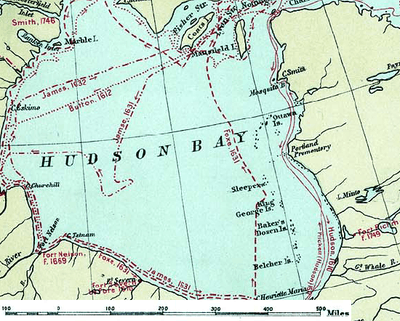
The Ottawa Islands (Inuit: Arviliit)[1] are a group of uninhabited islands situated in the eastern edge of Canada's Hudson Bay. The group comprises 24 small islands, located at approximately 60N 80W.[2] The main islands include Booth Island, Bronson Island, Eddy Island, Gilmour Island, J. Gordon Island, Pattee Island, and Perley Island. The highest point is on Gilmour Island, which rises to over 1,800 ft (550 m).[2] Located a short distance off the northwest coast of Quebec's Ungava Peninsula, they, like the other coastal islands in Hudson Bay, were historically part of the Northwest Territories, and became part of the territory of Nunavut upon its creation in 1999.[3][4]
Geography
The Ottawa Islands are situated on the barren and rocky east coast of Hudson Bay.[5] By 1610 Hudson Bay had been explored and named by Henry Hudson in his quest for a Northwest Passage.[5] It wasn't until 1631 when Luke Foxe (or Fox) on a voyage from "Vltimum Vale" (Cape Henrietta Maria), near 57° 40', indicated that "Mr. Hudson calls those islands by the name of 'Lancaster's Iles.' "[6] According to historian T.H. Manning, there is no other record of Henry Hudson naming islands in that region.[7] A little further north, near 58° 5', Capt. Foxe says "Wee came by a small Iland at clocke one, the highest I haue seene since I came from Brook Cobham; the deep 70 fathome. I named the Ile Sleepe."[8] Foxe named the islands just north of Lancaster Isle, "Ile Sleepe". According to Manning, the name, having eventually changed to "Sleeper Island" or "The Sleepers", could be used "for the islands between and including Lancaster and Ottawa Islands."[7]
Further coordinate readings
Fauna
The Ottawa Islands and the southwardly Belcher Islands are a breeding ground for "the Hudson Bay subspecies of the Common Eider".[9] In 1765 commercial whaling of bowheads was started by Churchill-based sloops of the Hudson's Bay Company with some whales being harvested in the Ottawa Islands.[10] By 1992 and 1993, hunters from Inukjuak failed to locate any walruses.[10]
See also
References
- ↑ Issenman, Betty. Sinews of Survival: The living legacy of Inuit clothing. UBC Press, 1997. pp252-254
- 1 2 Columbia Gazetteer of North America, accessed May 30, 2007
- ↑ Standard Geographical Classification Volume II: Reference Maps (SGC 2006). Online database: Map Series: Census Division - Census Subdivision. Geography: 23. Nunavut (9.9 MB). Map "Nunavut". Statistics Canada, Ottawa, 2007. Accessed 05-11-2007. Note: This information is based on the analysis of primary information provided within the map and is supported by secondary information in reference #2 (NRCAN). Reference #2 clearly states that the location of Ottawa Islands is within Nunavut. By cross referencing with NRCAN, it is possible to conclude that Ottawa Islands is not only part of Nunavut but of Census Division #4 or Baffin Region, Nunavut.
- ↑ Toparama - Topographic Maps from Natural Resources Canada
- 1 2 "Hudson Bay." The Columbia Electronic Encyclopedia, Sixth Edition. Columbia University Press., 2003. Answers.com 26 Jan. 2007. Accessed 01-26-2007.
- ↑ Miller Christy, ed., "The Voyage of Capt. Luke Fox of Hull and Capt. Thomas James of Bristol, in search of North-west Passage, 1631-2", (Hakluyt Soc., Vols. 88, 89, 1894), p.368. Taken from; Manning, T.H., "Explorations on the East Coast of Hudson Bay". The Geographical Journal, Vol. 109, No. 1/3 (Jan. - Mar., 1947), pp. 58-75, doi:10.2307/1789902, Republished by JSTOR, Accessed 01-26-2007.
- 1 2 3 Manning, T.H., "Explorations on the East Coast of Hudson Bay". The Geographical Journal, Vol. 109, No. 1/3 (Jan. - Mar., 1947), pp. 58-75, doi:10.2307/1789902, Republished by JSTOR, Accessed 01-26-2007.
- ↑ Miller Christy, op. cit. p.369. Taken from; Manning, T.H., op. cit.
- ↑ "National Marine Conservation Areas of Canada: Canada's National Marine Conservation Areas System Plan: James Bay: The Wildlife". Parks Canada, Last Updated: 2006-11-17, Accessed 01-26-2007.
- 1 2 Government of Canada - Fisheries and Oceans Canada. "Harvesting" Chapter 14.5.3, page 14-19. Information originally sourced from (Flaherty 1918; Newspaper Clipping in PAC, MG 29, A58, Vol 8.,File 5 in Reeves and Mitchell 1987). Accessed 06-11-2007
Bibliography
- Manning, T. H. Birds and Mammals of the Belcher, Sleeper, Ottawa and King George Islands, and Northwest Territories. Ottawa: Canadian Wildlife Service, 1976.
- Manning, T.H., "Ruins of Eskimo Stone Houses on the East Side of Hudson Bay". American Antiquity, Vol. 11, No. 3 (Jan., 1946), pp. 201–202. doi:10.2307/275565, Republished by JSTOR, Web Link, Accessed 01-26-2007.
External links
- Toparama - Topographic Maps from Natural Resources Canada
- 2006 Beluga Statistics From Weekly Reports (Contains a map of the region)
- The Atlas of Canada, map of Ottawa Islands from 1976
- Plant and Phytoplankton study of Hudson Bay