Ovid, Michigan
| Ovid, Michigan | |
|---|---|
| City | |
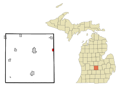 Location of Ovid Michigan | |
| Coordinates: 43°0′21″N 84°22′22″W / 43.00583°N 84.37278°W | |
| Country | United States |
| State | Michigan |
| Counties | Clinton, Shiawassee |
| Area[1] | |
| • Total | 0.92 sq mi (2.38 km2) |
| • Land | 0.92 sq mi (2.38 km2) |
| • Water | 0 sq mi (0 km2) |
| Elevation | 728 ft (222 m) |
| Population (2010)[2] | |
| • Total | 1,603 |
| • Estimate (2012[3]) | 1,607 |
| • Density | 1,742.4/sq mi (672.7/km2) |
| Time zone | Eastern (EST) (UTC-5) |
| • Summer (DST) | EDT (UTC-4) |
| ZIP code | 48866 |
| Area code(s) | 989 |
| FIPS code | 26-61860[4] |
| GNIS feature ID | 0634234[5] |
| Website | http://www.ovidmich.com/ |
Ovid is a city in Clinton and Shiawassee counties in the U.S. state of Michigan. Nearly all of the city is located within Ovid Township in Clinton County. The population was 1,603 at the 2010 census.
The city is on M-21, about 9 miles (14 km) east of St. Johns and about 10 miles (16 km) west of Owosso.
In November 2015 Voters approved a charter to alter the municipality from a village to a city.
Geography
According to the United States Census Bureau, the city has a total area of 0.92 square miles (2.38 km2), all land.[1]
Demographics
| Historical population | |||
|---|---|---|---|
| Census | Pop. | %± | |
| 1880 | 1,479 | — | |
| 1890 | 1,423 | −3.8% | |
| 1900 | 1,293 | −9.1% | |
| 1910 | 1,078 | −16.6% | |
| 1920 | 1,067 | −1.0% | |
| 1930 | 1,131 | 6.0% | |
| 1940 | 1,248 | 10.3% | |
| 1950 | 1,410 | 13.0% | |
| 1960 | 1,505 | 6.7% | |
| 1970 | 1,650 | 9.6% | |
| 1980 | 1,712 | 3.8% | |
| 1990 | 1,442 | −15.8% | |
| 2000 | 1,514 | 5.0% | |
| 2010 | 1,603 | 5.9% | |
| Est. 2015 | 1,612 | [6] | 0.6% |

2010 census
As of the census[2] of 2010, there were 1,603 people, 578 households, and 398 families residing in the city. The population density was 1,742.4 inhabitants per square mile (672.7/km2). There were 618 housing units at an average density of 671.7 per square mile (259.3/km2). The racial makeup of the city was 95.7% White, 0.4% African American, 0.3% Native American, 0.1% Asian, 0.1% Pacific Islander, 1.3% from other races, and 2.1% from two or more races. Hispanic or Latino of any race were 5.7% of the population.
There were 578 households of which 41.3% had children under the age of 18 living with them, 43.1% were married couples living together, 18.9% had a female householder with no husband present, 6.9% had a male householder with no wife present, and 31.1% were non-families. 25.6% of all households were made up of individuals and 10% had someone living alone who was 65 years of age or older. The average household size was 2.63 and the average family size was 3.12.
The median age in the city was 35 years. 29.4% of residents were under the age of 18; 7.7% were between the ages of 18 and 24; 27.2% were from 25 to 44; 20.5% were from 45 to 64; and 15.2% were 65 years of age or older. The gender makeup of the city was 45.6% male and 54.4% female.
2000 census
As of the census[4] of 2000, there were 1,514 people, 575 households, and 400 families residing in the city. The population density was 1,634.9 per square mile (628.6/km²). There were 604 housing units at an average density of 652.2 per square mile (250.8/km²). The racial makeup of the city was 96.30% White, 0.13% African American, 0.59% Native American, 0.13% Pacific Islander, 1.25% from other races, and 1.59% from two or more races. Hispanic or Latino of any race were 4.23% of the population.
There were 575 households out of which 38.1% had children under the age of 18 living with them, 51.1% were married couples living together, 14.8% had a female householder with no husband present, and 30.3% were non-families. 23.5% of all households were made up of individuals and 8.3% had someone living alone who was 65 years of age or older. The average household size was 2.63 and the average family size was 3.13.
In the city the population was spread out with 29.6% under the age of 18, 10.8% from 18 to 24, 29.6% from 25 to 44, 18.5% from 45 to 64, and 11.6% who were 65 years of age or older. The median age was 32 years. For every 100 females there were 90.2 males. For every 100 females age 18 and over, there were 85.1 males.
The median income for a household in the city was $33,333, and the median income for a family was $38,235. Males had a median income of $33,438 versus $22,083 for females. The per capita income for the city was $15,324. About 10.5% of families and 11.5% of the population were below the poverty line, including 16.9% of those under age 18 and 3.1% of those age 65 or over.
Education
Ovid and nearby Elsie are served by the Ovid-Elsie Area Schools, which operates two elementary schools, one middle school, one high school, and a community center which houses pre-school and alternative high school programs.
Elementary schools
- Leonard Elementary School, in Ovid
- E.E. Knight Elementary School, in Elsie
Middle school
- Ovid-Elsie Middle School, in Elsie
High schools
- Ovid-Elsie High School, in Elsie
Former school
- North Elementary School, in Ovid - Now the North Community Center.
Notable people
- Louis Filler - American social historian
- Matt Prieur - Former announcer for the ASA Late Model Series
- Mark Bashore - DJ, Broadcast Journalist, Voiceover Actor
- Dale Willett - Historian, and retired professor
Points of interest
- Ovid Carriage Days, a weekend long annual festival held in late September.
- Owosso Speedway, a high-banked 3/8-mile paved oval.
References
- 1 2 "US Gazetteer files 2010". United States Census Bureau. Retrieved 2012-11-25.
- 1 2 "American FactFinder". United States Census Bureau. Retrieved 2012-11-25.
- ↑ "Population Estimates". United States Census Bureau. Retrieved 2013-06-03.
- 1 2 "American FactFinder". United States Census Bureau. Retrieved 2008-01-31.
- ↑ "US Board on Geographic Names". United States Geological Survey. 2007-10-25. Retrieved 2008-01-31.
- ↑ "Annual Estimates of the Resident Population for Incorporated Places: April 1, 2010 to July 1, 2015". Retrieved July 2, 2016.
- ↑ "Census of Population and Housing". Census.gov. Retrieved June 4, 2015.
Municipalities and communities of Clinton County, Michigan, United States | ||
|---|---|---|
| Cities |  | |
| Villages | ||
| Charter townships | ||
| General law townships | ||
| CDPs | ||
| Footnotes | ‡This populated place also has portions in an adjacent county or counties | |
Municipalities and communities of Shiawassee County, Michigan, United States | ||
|---|---|---|
| Cities |  | |
| Villages | ||
| Charter townships | ||
| General law townships | ||
| Unincorporated communities | ||
| Footnotes | ‡This populated place also has portions in an adjacent county | |
Coordinates: 43°00′21″N 84°22′18″W / 43.00583°N 84.37167°W