Paint, Pennsylvania
| Paint, Pennsylvania | |
|---|---|
| Borough | |
|
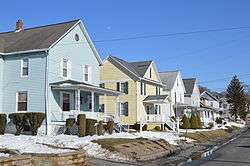
Bedford St. in the historic district | |
 Paint, Pennsylvania | |
| Coordinates: 40°14′36″N 78°50′46″W / 40.24333°N 78.84611°WCoordinates: 40°14′36″N 78°50′46″W / 40.24333°N 78.84611°W | |
| Country | United States |
| State | Pennsylvania |
| County | Somerset |
| Incorporated | 1900 |
| Government | |
| • Type | Borough Council |
| Area | |
| • Total | 0.3 sq mi (0.8 km2) |
| Population (2000) | |
| • Total | 1,103 |
| • Density | 3,152.5/sq mi (1,217.2/km2) |
| Time zone | Eastern (EST) (UTC-5) |
| • Summer (DST) | EDT (UTC-4) |
| Area code(s) | 814 |
Paint is a borough in Somerset County, Pennsylvania, United States. The population was 1,103 at the 2000 census. It is part of the Johnstown, Pennsylvania Metropolitan Statistical Area.
History
The Windber Historic District was listed on the National Register of Historic Places in 1991.[1]
Geography
Paint is located at 40°14′36″N 78°50′46″W / 40.24333°N 78.84611°W (40.243423, -78.846092).[2]
According to the United States Census Bureau, the borough has a total area of 0.3 square miles (0.78 km2), all of it land.
Demographics
| Historical population | |||
|---|---|---|---|
| Census | Pop. | %± | |
| 1910 | 999 | — | |
| 1920 | 1,283 | 28.4% | |
| 1930 | 1,336 | 4.1% | |
| 1940 | 1,700 | 27.2% | |
| 1950 | 1,547 | −9.0% | |
| 1960 | 1,275 | −17.6% | |
| 1970 | 1,233 | −3.3% | |
| 1980 | 1,177 | −4.5% | |
| 1990 | 1,091 | −7.3% | |
| 2000 | 1,103 | 1.1% | |
| 2010 | 1,023 | −7.3% | |
| Est. 2015 | 968 | [3] | −5.4% |
| Sources:[4][5][6] | |||
As of the census[5] of 2000, there were 1,103 people, 397 households, and 273 families residing in the borough. The population density was 3,152.5 people per square mile (1,216.8/km²). There were 432 housing units at an average density of 1,234.7 per square mile (476.6/km²). The racial makeup of the borough was 98.37% White, 0.54% African American, 0.18% Asian, and 0.91% from two or more races. Hispanic or Latino of any race were 0.18% of the population.
There were 397 households out of which 25.9% had children under the age of 18 living with them, 52.4% were married couples living together, 11.1% had a female householder with no husband present, and 31.0% were non-families. 29.2% of all households were made up of individuals and 19.9% had someone living alone who was 65 years of age or older. The average household size was 2.31 and the average family size was 2.83.
In the borough the population was spread out with 17.9% under the age of 18, 4.7% from 18 to 24, 21.4% from 25 to 44, 17.6% from 45 to 64, and 38.4% who were 65 years of age or older. The median age was 51 years. For every 100 females there were 77.6 males. For every 100 females age 18 and over, there were 71.9 males.
The median income for a household in the borough was $28,571, and the median income for a family was $35,833. Males had a median income of $25,179 versus $18,611 for females. The per capita income for the borough was $14,351. About 7.0% of families and 9.5% of the population were below the poverty line, including 17.6% of those under age 18 and 8.6% of those age 65 or over.
References
- ↑ National Park Service (2010-07-09). "National Register Information System". National Register of Historic Places. National Park Service.
- ↑ "US Gazetteer files: 2010, 2000, and 1990". United States Census Bureau. 2011-02-12. Retrieved 2011-04-23.
- ↑ "Annual Estimates of the Resident Population for Incorporated Places: April 1, 2010 to July 1, 2015". Retrieved July 2, 2016.
- ↑ "Census of Population and Housing". U.S. Census Bureau. Retrieved 11 December 2013.
- 1 2 "American FactFinder". United States Census Bureau. Retrieved 2008-01-31.
- ↑ "Incorporated Places and Minor Civil Divisions Datasets: Subcounty Resident Population Estimates: April 1, 2010 to July 1, 2012". Population Estimates. U.S. Census Bureau. Retrieved 11 December 2013.
Municipalities and communities of Somerset County, Pennsylvania, United States | ||
|---|---|---|
| Boroughs | 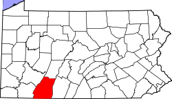 | |
| Townships | ||
| CDPs | ||
| Unincorporated communities | ||
| Footnotes | ‡This populated place also has portions in an adjacent county or counties | |