Palestine Township, Cooper County, Missouri
| Palestine Township | |
|---|---|
| Township | |
 Location in Cooper County | |
| Coordinates: 38°51′16″N 92°50′31″W / 38.85444°N 92.84194°WCoordinates: 38°51′16″N 92°50′31″W / 38.85444°N 92.84194°W | |
| Country |
|
| State |
|
| County | Cooper |
| Area | |
| • Total | 44.97 sq mi (116.48 km2) |
| • Land | 44.92 sq mi (116.34 km2) |
| • Water | 0.06 sq mi (0.15 km2) 0.13% |
| Elevation | 745 ft (227 m) |
| Population (2000) | |
| • Total | 367 |
| • Density | 8.2/sq mi (3.2/km2) |
| Time zone | CST (UTC-6) |
| • Summer (DST) | CDT (UTC-5) |
| ZIP codes | 65233, 65237, 65276 |
| GNIS feature ID | 0766535 |
Palestine Township is one of fourteen townships in Cooper County, Missouri, USA. As of the 2000 census, its population was 367.[1]
Geography
According to the United States Census Bureau, Palestine Township covers an area of 44.97 square miles (116.48 square kilometers); of this, 44.92 square miles (116.34 square kilometers, 99.88 percent) is land and 0.06 square miles (0.15 square kilometers, 0.13 percent) is water.
Unincorporated towns
- Bellair at 38°49′59″N 92°50′40″W / 38.833078°N 92.844359°W
- Speed at 38°50′53″N 92°48′12″W / 38.848079°N 92.803247°W
(This list is based on USGS data and may include former settlements.)
Adjacent townships
- Boonville Township (northeast)
- Clark Fork Township (east)
- Kelly Township (south)
- Lebanon Township (southwest)
- Clear Creek Township (west)
- Pilot Grove Township (northwest)
Cemeteries
The township contains these three cemeteries: Briscoe, Concord and Concord.
Major highways
School districts
- Boonville School District
- Cooper County C-4
- Pilot Grove C-4
Political districts
- Missouri's 6th congressional district
- State House District 117
- State Senate District 21
References
- United States Census Bureau 2008 TIGER/Line Shapefiles
- United States Board on Geographic Names (GNIS)
- United States National Atlas
External links
 |
Pilot Grove Township | |
Boonville Township | |
| Clear Creek Township | |
Clark Fork Township | ||
| ||||
| | ||||
| Lebanon Township | Kelly Township |
Municipalities and communities of Cooper County, Missouri, United States | ||
|---|---|---|
| Cities | 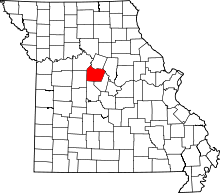 | |
| Villages | ||
| Townships | ||
| Unincorporated communities | ||
This article is issued from Wikipedia - version of the 11/16/2013. The text is available under the Creative Commons Attribution/Share Alike but additional terms may apply for the media files.