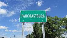
Pancoastburg, Ohio
| Pancoastburg, Ohio | |
|---|---|
| Census-designated place | |
|
Looking north on Ohio Highway 207 in Pancoastburg | |
 Pancoastburg  Pancoastburg Location of Pancoastburg, Ohio | |
| Coordinates: 39°37′28″N 83°15′56″W / 39.62444°N 83.26556°W | |
| Country | United States |
| State | Ohio |
| County | Fayette |
| Township | Madison |
| Area | |
| • Total | 0.35 sq mi (0.90 km2) |
| • Land | 0.34 sq mi (0.88 km2) |
| • Water | 0.004 sq mi (0.01 km2) |
| Elevation[1] | 866 ft (264 m) |
| Population | |
| • Total | 87 |
| • Density | 255/sq mi (98.6/km2) |
| Time zone | Eastern (EST) (UTC-5) |
| • Summer (DST) | EDT (UTC-4) |
| ZIP code | 43160 |
| Area code(s) | 740 |
| GNIS feature ID | 1070889[1] |
| FIPS code | 39-59724 |
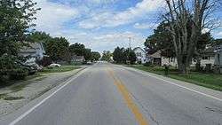
Pancoastburg (originally known as Pancoastburgh) is an unincorporated community and census-designated place (CDP) in Madison Township, Fayette County, Ohio, United States.[2] It is located at 39°37′28″N 83°15′56″W / 39.62444°N 83.26556°WCoordinates: 39°37′28″N 83°15′56″W / 39.62444°N 83.26556°W,[3] along Ohio State Route 207, about 6 miles (10 km) south of Mount Sterling.[4] As of the 2010 census the population of Pancoastburg was 87.[5]
History
Samuel Pancoast established a carding mill at Pancoastburg in the 1820s.[6] The Pancoastburg post office was established as "Pancoastburgh" on August 19, 1847. The name was changed to "Pancoastburg" on May 16, 1893, and was discontinued on December 15, 1920. The mail service is now sent through the Washington Court House branch.[7]
The Jackson Mound is located 4 miles (6 km) north of Pancoastburg; built by the Adena culture, it is the last Native American mound in existence in Fayette County.[8]
References
- 1 2 "US Board on Geographic Names". United States Geological Survey. 2007-10-25. Retrieved 2008-01-31.
- ↑ U.S. Geological Survey Geographic Names Information System: Pancoastburg, Ohio
- ↑ U.S. Geological Survey Geographic Names Information System: Pancoastburg, Ohio
- ↑ Rand McNally. The Road Atlas '06. Chicago: Rand McNally, 2006, 80.
- ↑ "Geographic Identifiers: 2010 Census Summary File 1 (G001), Pancoastburg CDP, Ohio". American FactFinder. U.S. Census Bureau. Retrieved July 1, 2016.
- ↑ Allen, Frank M. (1914). History of Fayette County, Ohio: Her People, Industries and Institutions. B. F. Bowen, Incorporated. p. 343.
- ↑ U.S. Geological Survey Geographic Names Information System: Pancoastburg Post Office
- ↑ Ohio Historic Places Dictionary. North American Book Dist LLC. 2008. p. 410. ISBN 978-1-878592-70-5.
Municipalities and communities of Fayette County, Ohio, United States | ||
|---|---|---|
| City | 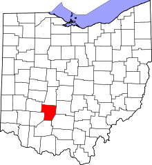 | |
| Villages | ||
| Townships | ||
| CDPs | ||
| Unincorporated communities | ||
| Footnotes | ‡This populated place also has portions in an adjacent county or counties | |