Park Rapids, Minnesota
| Park Rapids, Minnesota | |
|---|---|
| City | |
|
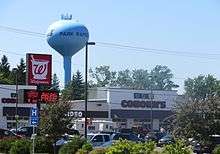
Photo: Bill Johnson | |
 Location of Park Rapids within Hubbard County and state of Minnesota | |
| Coordinates: 46°55′N 95°3′W / 46.917°N 95.050°W | |
| Country | United States |
| State | Minnesota |
| County | Hubbard |
| Area[1] | |
| • Total | 6.81 sq mi (17.64 km2) |
| • Land | 6.59 sq mi (17.07 km2) |
| • Water | 0.22 sq mi (0.57 km2) |
| Elevation | 1,440 ft (439 m) |
| Population (2010)[2] | |
| • Total | 3,709 |
| • Estimate (2013[3]) | 3,903 |
| • Density | 562.8/sq mi (217.3/km2) |
| Time zone | Central (CST) (UTC-6) |
| • Summer (DST) | CDT (UTC-5) |
| ZIP code | 56470 |
| Area code(s) | 218 Exchange: 732 |
| FIPS code | 27-49768 |
| GNIS feature ID | 0649151[4] |
| Website | City of Park Rapids |

Park Rapids is a city in and the county seat of Hubbard County, Minnesota, United States.[5] It is near Itasca State Park, the source of the Mississippi River,[6] as well as the beginning of the Heartland State Trail.[7] The city was founded in 1890 near the Fish Hook River rapids[8] and is located along U.S. Highway 71 and Minnesota State Highway 34.[9] The population was 3,709 at the 2010 census.[10]
History
Park Rapids became a city in 1890, and was named by Frank C. Rice after the park groves and prairies beside the Fish Hook River rapids. These rapids have since been dammed.[8]
Infrastructure
Transportation
Park Rapids and the surrounding Hubbard County area have three major transportation services. For air travel, Park Rapids is serviced by the Municipal–Konshok Field Airport.[11] According to the FAA, the airfield is publicly owned by the City of Park Rapids and has a physical address of 212 W. 2nd Street, Park Rapids, MN 56470. Also serving the Park Rapids and Hubbard County area for ground transportation is the Hubbard County Heartland Express[12] bus service and a local taxi service.
Major highways
U.S. Highway 71 and Minnesota State Highway 34 are two of the main routes through Park Rapids. Highway 34 was expanded in 2008 into a five-lane route through the city.[13] Downtown Main Avenue has street "center parking". Highway 71 and Main Street were reconstructed during the summer of 2009.
Geography
According to the United States Census Bureau, the city has a total area of 6.81 square miles (17.64 km2), of which, 6.59 square miles (17.07 km2) is land and 0.22 square miles (0.57 km2) is water.[1] The Fish Hook River flows through the city.[14]
Climate
| Climate data for Park Rapids, Minnesota | |||||||||||||
|---|---|---|---|---|---|---|---|---|---|---|---|---|---|
| Month | Jan | Feb | Mar | Apr | May | Jun | Jul | Aug | Sep | Oct | Nov | Dec | Year |
| Record high °F (°C) | 51 (11) |
61 (16) |
74 (23) |
96 (36) |
96 (36) |
96 (36) |
100 (38) |
101 (38) |
99 (37) |
90 (32) |
72 (22) |
58 (14) |
101 (38) |
| Average high °F (°C) | 18 (−8) |
24 (−4) |
36 (2) |
54 (12) |
67 (19) |
74 (23) |
80 (27) |
78 (26) |
67 (19) |
53 (12) |
35 (2) |
21 (−6) |
50.6 (10.3) |
| Average low °F (°C) | −4 (−20) |
1 (−17) |
15 (−9) |
29 (−2) |
41 (5) |
51 (11) |
56 (13) |
54 (12) |
45 (7) |
32 (0) |
18 (−8) |
3 (−16) |
28.4 (−2) |
| Record low °F (°C) | −45 (−43) |
−51 (−46) |
−36 (−38) |
−8 (−22) |
14 (−10) |
28 (−2) |
35 (2) |
31 (−1) |
17 (−8) |
−2 (−19) |
−29 (−34) |
−46 (−43) |
−51 (−46) |
| Average precipitation inches (mm) | 0.52 (13.2) |
0.50 (12.7) |
1.13 (28.7) |
1.85 (47) |
3.10 (78.7) |
4.20 (106.7) |
4.10 (104.1) |
3.55 (90.2) |
3.08 (78.2) |
2.65 (67.3) |
0.96 (24.4) |
0.57 (14.5) |
26.21 (665.7) |
| Source: The Weather Channel[15] | |||||||||||||
Demographics
| Historical population | |||
|---|---|---|---|
| Census | Pop. | %± | |
| 1900 | 1,313 | — | |
| 1910 | 1,801 | 37.2% | |
| 1920 | 1,603 | −11.0% | |
| 1930 | 2,081 | 29.8% | |
| 1940 | 2,643 | 27.0% | |
| 1950 | 3,027 | 14.5% | |
| 1960 | 3,047 | 0.7% | |
| 1970 | 2,772 | −9.0% | |
| 1980 | 2,976 | 7.4% | |
| 1990 | 2,863 | −3.8% | |
| 2000 | 3,276 | 14.4% | |
| 2010 | 3,709 | 13.2% | |
| Est. 2015 | 3,947 | [16] | 6.4% |
| U.S. Decennial Census[17] 2013 Estimate[3] | |||
2010 census
As of the census[2] of 2010, there were 3,709 people, 1,772 households, and 892 families residing in the city. The population density was 562.8 inhabitants per square mile (217.3/km2). There were 2,003 housing units at an average density of 303.9 per square mile (117.3/km2). The racial makeup of the city was 94.1% White, 0.4% African American, 2.3% Native American, 0.1% Asian, 1.2% from other races, and 1.9% from two or more races. Hispanic or Latino of any race were 3.7% of the population.
There were 1,772 households of which 24.7% had children under the age of 18 living with them, 35.2% were married couples living together, 11.6% had a female householder with no husband present, 3.5% had a male householder with no wife present, and 49.7% were non-families. 44.9% of all households were made up of individuals and 22.5% had someone living alone who was 65 years of age or older. The average household size was 2.03 and the average family size was 2.80.
The median age in the city was 43.1 years. 22.1% of residents were under the age of 18; 8.4% were between the ages of 18 and 24; 21.7% were from 25 to 44; 22.8% were from 45 to 64; and 24.9% were 65 years of age or older. The gender makeup of the city was 46.3% male and 53.7% female.
2000 census
As of the census of 2000, there were 3,276 people, 1,476 households, and 788 families residing in the city. The population density was 547.5 people per square mile (211.5/km²). There were 1,616 housing units at an average density of 270.1 per square mile (104.3/km²). The racial makeup of the city was 95.97% White, 0.31% African American, 2.20% Native American, 0.37% Asian, 0.03% Pacific Islander, 0.46% from other races, and 0.67% from two or more races. Hispanic or Latino of any race were 1.07% of the population.
There were 1,476 households out of which 25.3% had children under the age of 18 living with them, 39.2% were married couples living together, 10.8% had a female householder with no husband present, and 46.6% were non-families. 41.8% of all households were made up of individuals and 23.3% had someone living alone who was 65 years of age or older. The average household size was 2.11 and the average family size was 2.88.
In the city the population was spread out with 23.5% under the age of 18, 7.8% from 18 to 24, 21.9% from 25 to 44, 18.8% from 45 to 64, and 28.1% who were 65 years of age or older. The median age was 42 years. For every 100 females there were 81.7 males. For every 100 females age 18 and over, there were 77.3 males.
The median income for a household in the city was $23,628, and the median income for a family was $33,958. Males had a median income of $28,718 versus $21,827 for females. The per capita income for the city was $16,416. About 11.6% of families and 12.2% of the population were below the poverty line, including 11.3% of those under age 18 and 13.1% of those age 65 or over.[18]
Notable people
Park Rapids is the birthplace of two notable authors: Will Weaver (1950-) and Nathan Aaseng (1953-). Weaver was born to a farming family but was educated at Saint Cloud State University, the University of Minnesota, and Stanford University. He worked as a farmer, an educator, and a fiction writer. Three of his best-known novels are Striking Out, Farm Team, and Hard Ball. They reflect Weaver's upbringing on a northern Minnesota farm. His writings have won several awards, including the Friends of American Writers Award (1989) and the Minnesota Book Award for Fiction (1989). Weaver now lives in Bemidji, MN.[19]
Nathan Aaseng was the son of a minister and attended Luther College and Luther Seminary. He worked as a microbiologist-biochemist and wrote juvenile nonfiction and fiction. His works include more than 130 books on a variety of subjects. Some examples are Big Red, Wild Trek, and the "You Are the Coach" series.[20]
John A. Ainley, Jr., Minnesota newspaper editor and legislator, lived in Park Rapids.[21]
Thomas Miller, Iowa newspaper editor and legislator was born in Park Rapids.[22]
Esther Miriam Fieldman, businesswoman and Minnesota state legislator, lived in Park Rapids.[23]
Recreation
There are over seventy lakes in the Park Rapids area, which all offer distinct fishing opportunities. Some of the notable nearby lakes include Lake Itasca (headwaters of the Mississippi River) as well as some of the numerous Crow Wing Lakes. Some of the most common fish caught within the area include largemouth, smallmouth and rock bass, bullhead, crappie, northern pike, perch, sunfish and walleye.[24] The Heartland Trail, which is one of the oldest rail-to-trail projects in the United States,[7] begins in Park Rapids. The forty-nine mile trail is open to horseback riding, hiking, snowmobiling, and biking at different segments throughout. Deer, coyote, grey wolf, chipmunks, bobcat, bear, bald eagle, red fox, raccoon, beaver and muskrat can all be spotted along the trail.

Local media
Park Rapids is home to De La Hunt Broadcasting, located east of the city's downtown. There are three radio stations in Park Rapids:
- KPRM AM 870, (Talk and Classic Country)
- KXKK FM 92.5, (Country Music)
- KDKK FM 97.5, (Adult Standards)
Park Rapids receives five TV stations:
- KAWE Ch. 9 PBS (Bemidji)
- KVLY-TV Ch. 11 NBC (Fargo)
- KCCW Ch. 12 CBS (Walker)
- KVRR Ch. 15 FOX (Fargo)
- KSAX Ch. 42 ABC (Alexandria)
The local newspaper is the Park Rapids Enterprise. The local cable TV provider is Arvig Communication Systems.
Education
Park Rapids Area High School serves grades 9–12, and is located on 401 Huntsinger Avenue in Park Rapids.[25] Century School houses grades K–8, and is located on 501 Helten Avenue. The latter was finished in 2001.[26]
Park Avenue School of Cosmetology opened in 2006. It offers programs in cosmetology, nail technology, and esthetics.[27]
Park Rapids had two separate buildings for primary school that split up K–4 and 9–12 from grades 5–8. Frank White Elementary and Park Rapids High School were part of the same building. The Century School was built in 2001 to accommodate grades K–8. The Frank White Elementary School was remodeled and pieces of it became part of the Park Rapids Area High School, while several of the Frank White classrooms became preschool classrooms. The old Park Rapids Middle School was sold several times and part of it is now apartments.
References
- 1 2 "US Gazetteer files 2010". United States Census Bureau. Archived from the original on July 14, 2012. Retrieved 2012-11-13.
- 1 2 "American FactFinder". United States Census Bureau. Retrieved 2012-11-13.
- 1 2 "Population Estimates". United States Census Bureau. Retrieved 2014-07-18.
- ↑ "US Board on Geographic Names". United States Geological Survey. 2007-10-25. Retrieved 2008-01-31.
- ↑ "Find a County". National Association of Counties. Archived from the original on May 31, 2011. Retrieved 2011-06-07.
- ↑ Minnesota Department of Natural Resources. 2008. The Minnesota Department of Natural Resources Web Site (online). Accessed 2008-11-25 at http://www.dnr.state.mn.us/sitetools/copyright.html
- 1 2 "Heartland State Trail: Minnesota". Retrieved 2 April 2012.
- 1 2 Warren Upham, (2008). Minnesota Geographic Names: Their Origin and Historic Significance. Minnesota Historical Society, 1920. Harvard University. Digitized Aug 8, 2007. pp. 244
- ↑ City of Park Rapids. 2008. The city of Park Rapids, MN Web site (online). Accessed 2008-12-02 at City of Park Rapids
- ↑ "2010 Census Redistricting Data (Public Law 94-171) Summary File". American FactFinder. U.S. Census Bureau, 2010 Census. Archived from the original on July 21, 2011. Retrieved 23 April 2011.
- ↑ Park Rapids "Park Rapids Municipal-Konshok Field Airport." AirNav.com. AirNav, LLC. Web. 30 Mar. 2012.
- ↑ "Hubbard County." Public Transit in Minnesota. Minnesota Department of Transportation, 2012. Web. 30 Mar. 2012.
- ↑ City of Park Rapids. 2008. The city of Park Rapids, MN Web site (online). Accessed 2008-12-02.
- ↑ Minnesota Atlas & Gazetteer. Yarmouth, Me.: DeLorme. 1994. p. 61. ISBN 0-89933-222-6.
- ↑ "Seasonal Temperature and Precipitation Information". The Weather Channel. August 2011. Retrieved 2012-03-11.
- ↑ "Annual Estimates of the Resident Population for Incorporated Places: April 1, 2010 to July 1, 2015". Retrieved July 2, 2016.
- ↑ United States Census Bureau. "Census of Population and Housing". Archived from the original on May 11, 2015. Retrieved July 18, 2014.
- ↑ "American FactFinder". United States Census Bureau. Archived from the original on September 11, 2013. Retrieved 2008-01-31.
- ↑ "Weaver, Will(iam (Weller) (1950-)." UXL DISCovering Authors (online). Discovering Collection. Gale. 2003. Retrieved 2012-03-23.
- ↑ "Aaseng, Nathan (1953-)." UXL DISCovering Authors (online). Discovering Collection. Gale. 2003. Retrieved 2012-03-23.
- ↑ 'John Ainley, former legislator and newspaper editor, dies,' Minneapolis Star Tribune, Kavita Kumar, May 4, 2001
- ↑ 'William H. Miller-obituary,' Cherokee Daily Times, May 31, 2001, pg. 2
- ↑ 'Esther Miriam Fieldman-obituary,' Minneapolis Star-Tribune, July 2, 2007
- ↑ Billig, James (1994). Park Rapids Area Fishing Map Guide. Duluth: Sportsman's Connection.
- ↑ "Park Rapids Area High School." Park Rapids Area School District 309. 2011. Retrieved 25 April 2012
- ↑ "Century Elementary." Park Rapids Area School District 309. 2011. Retrieved 25 April 2012
- ↑ "About Us." Park Avenue School of Cosmetology. 2004-2012. Retrieved 25 April 2012.
External links
| Wikimedia Commons has media related to Park Rapids. |
- Park Rapids Chamber
- Area Lodging Association
- Park Rapids Government
- De La Hunt Broadcasting
- Park Rapids Enterprise
- Park Rapids Area School District 309
- Park Avenue School of Cosmetology
- Park Rapids Webcam
- State Bank of Park Rapids
Municipalities and communities of Hubbard County, Minnesota, United States | ||
|---|---|---|
| Cities | 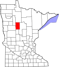 | |
| Townships | ||
| CDP | ||
| Unincorporated communities | ||
| Indian reservation | ||
| Footnotes | ‡This populated place also has portions in an adjacent county or counties | |
Coordinates: 46°55′N 95°03′W / 46.917°N 95.050°W