Payson, Utah
| Payson, Utah | |
|---|---|
| City | |
|
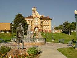
Peteetneet Museum in Payson | |
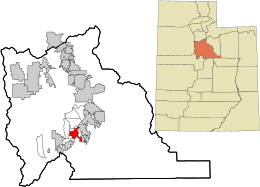 Location in Utah County and the state of Utah | |
| Coordinates: 40°2′20″N 111°43′59″W / 40.03889°N 111.73306°WCoordinates: 40°2′20″N 111°43′59″W / 40.03889°N 111.73306°W | |
| Country | United States |
| State | Utah |
| County | Utah |
| Founded | 1850 |
| Incorporated | January 21, 1853 |
| Government | |
| • Mayor | Rick Moore |
| Area | |
| • Total | 8.7 sq mi (22.5 km2) |
| • Land | 8.6 sq mi (22.4 km2) |
| • Water | 0.008 sq mi (0.02 km2) |
| Elevation | 4,700 ft (1,418 m) |
| Population (2012) | |
| • Total | 18,938 |
| • Density | 2,200/sq mi (840/km2) |
| Time zone | Mountain (UTC-7) |
| • Summer (DST) | Mountain (UTC-6) |
| ZIP code | 84651 |
| Area code(s) | 385, 801 |
| FIPS code | 49-58730[1] |
| GNIS feature ID | 1444252[2] |
| Website | http://www.paysonutah.org |
Payson is a city in Utah County, Utah, United States. It is part of the Provo–Orem Metropolitan Statistical Area. The population was 18,294 at the 2010 census.[3] The current mayor is Rick Moore, who in the 2009 election was the first write-in candidate to defeat an incumbent mayor in the state of Utah.[4]
History
The Latter-day Saints first settled in Payson in 1850.[5] It was originally named Peteetneet Creek, after Chief Peteetneet, a Timpanogos Indian chief who lived near Payson's current location. It was later renamed Payson by Brigham Young.
The Payson Tabernacle of The Church of Jesus Christ of Latter-day Saints was dedicated by Wilford Woodruff in 1872.[6]
In 1873 a high school was established in Payson, the first such institution in Utah south of Salt Lake City. It closed in 1876 due to the rise of Brigham Young Academy.[7] An opera house was built in Payson in 1883.[8] In the late 1800s, a factory making horse collars operated in Payson.[9]
When the Strawberry Valley Reclamation Project was completed in 1912, the Utah-Idaho Sugar Company decided to place a sugar beet processing factory in the area.[10] The plant was completed in October 1913.[10] By 1915, the biggest year for the factory, 5,014 acres (20.29 km2) were planted, yielding 36,915 tons of sugar beets, which were processed into 7,722 tons of sugar.[10] Due to low yields, the plant was closed in 1926 and dismantled in 1940; harvests were processed in the Utah-Idaho Sugar factories in Lehi and Spanish Fork.[10]
Demographics
| Historical population | |||
|---|---|---|---|
| Census | Pop. | %± | |
| 1860 | 830 | — | |
| 1870 | 1,436 | 73.0% | |
| 1880 | 1,788 | 24.5% | |
| 1890 | 2,135 | 19.4% | |
| 1900 | 2,636 | 23.5% | |
| 1910 | 2,397 | −9.1% | |
| 1920 | 3,031 | 26.4% | |
| 1930 | 3,045 | 0.5% | |
| 1940 | 3,591 | 17.9% | |
| 1950 | 3,998 | 11.3% | |
| 1960 | 4,237 | 6.0% | |
| 1970 | 4,501 | 6.2% | |
| 1980 | 8,246 | 83.2% | |
| 1990 | 9,510 | 15.3% | |
| 2000 | 12,716 | 33.7% | |
| 2010 | 18,294 | 43.9% | |
| Est. 2015 | 19,548 | [11] | 6.9% |
As of the census[1] of 2000, there were 12,716 people, 3,654 households, and 3,058 families residing in the city. The population density was 1,871.8 people per square mile (723.1/km²). There were 3,855 housing units at an average density of 567.5 per square mile (219.2/km²). The racial makeup of the city was 94.02% White, 0.13% African American, 0.39% Native American, 0.38% Asian, 0.24% Pacific Islander, 3.52% from other races, and 1.33% from two or more races. Hispanic or Latino of any race were 6.79% of the population.
There were 3,654 households out of which 51.8% had children under the age of 18 living with them, 70.8% were married couples living together, 9.6% had a female householder with no husband present, and 16.3% were non-families. 14.3% of all households were made up of individuals and 6.8% had someone living alone who was 65 years of age or older. The average household size was 3.47 and the average family size was 3.87.
In the city the population was spread out with 38.3% under the age of 18, 12.8% from 18 to 24, 26.0% from 25 to 44, 14.8% from 45 to 64, and 8.2% who were 65 years of age or older. The median age was 24 years. For every 100 females there were 101.8 males. For every 100 females age 18 and over, there were 96.7 males.
The median income for a household in the city was $43,539, and the median income for a family was $47,491. Males had a median income of $32,244 versus $20,869 for females. The per capita income for the city was $14,588. About 7.0% of families and 7.3% of the population were below the poverty line, including 7.9% of those under age 18 and 9.3% of those age 65 or over.
Payson's population has doubled since 1990, when the population was 8,700. Payson was at the southern end of Utah valley's real estate boom.
Culture

Payson is the site of the annual Scottish Heritage Festival, held every July. Other annual festivities include a salmon supper, held every August, and the annual Onion Days festival, held every Labor Day weekend. The city also has band concerts in the Memorial Park, and has had such concerts since the early 1950s.
Payson is where most of the 1984 hit movie Footloose was filmed, in settings such as Payson High School and Sudsie's, a local car wash. The town was also one of the locations for the 1985 thriller Warning Sign. Payson was the setting of the 1975 children's movie Banjo the Woodpile Cat. The town is a film favorite for seminary videos filmed by the LDS Church. The popular Mormon film Baptists at Our Barbecue was also shot on Payson's historic Main Street. Most recently, Payson was used to film most of the Disney Channel movie Hatching Pete.
Payson was originally named Peteetneet, after a Ute Indian chief who lived near Payson's current location. However, the pioneering residents decided to change the name to Payson, after James Pace, due to the fact that no one outside of Payson knew how to spell or say Peteetneet. A monument still stands to Chief Peteetneet at the Peteetneet Museum and Cultural Arts Center, originally the first school in Payson. The Peteetneet Museum is a historical gem in the community and is known for its historical significance, beauty, and great sledding. A committee headed by Marv Loy Egget has recently raised funds for the Peteetneet Museum glass elevator. Construction was completed on it the summer of 2008.[13]
Payson celebrates its heritage through monuments such as the historic Main Street, Peteetneet Museum and Cultural Arts Center, and several Payson Historical Society markers that note houses and other sites in the city over a hundred years old.
The city was the birthplace of singer-songwriter Jewel.
It is the hometown of Disney animator and film producer Don Bluth.[14]
The city has large numbers of persons with Scottish and Scots-Irish ancestry. However, the expansion of the Salt Lake City metropolitan area into Payson has changed the city's ethnic and religious makeup with additions of Catholic (including Eastern Rite Catholic and Greek Catholic brought in by Greek, Italian and Yugoslav settlers), Presbyterian, Evangelist, and Wiccan. Payson, like Provo, has a predominantly Mormon population, but other religious sects and denominations such as Lutherans, Methodists, Roman Catholics and Southern Baptists. The imprint of Scandinavian settlement is found in thousands of residents with Scandinavian (i.e. Danish, Norwegian and Swedish) surnames, as well thousands of Icelanders and Norwegians settled the Payson-Spanish Fork area in the 1850s; Swiss people and Austrians; and since the 1930s, Mexican Americans among a few other Hispanics and Latinos.[15][16]
On January 25, 2010, the LDS Church announced that a temple was to be built in Payson, the Payson Utah Temple.[17]
Schools
Payson is served by Nebo School District. Public schools in this district within Payson include the following: Payson High School, Payson Junior High School, Mt. Nebo Jr. High, Barnett Elementary, Parkview Elementary, Springlake Elementary, Taylor Elementary, Wilson Elementary. Payson High School is one of the very few schools in the USA that has its own Bagpipe Band.
Annual events
Payson is home to the Onion Days and Salmon Supper events held every August[18] and an annual Scottish Festival.[19]
Notable people
- Jesse Knight, rancher, mining magnate, industrialist
- O. Raymond Knight, rancher, rodeo champion, father of Canadian professional rodeo, hall of fame inductee
References
- 1 2 "American FactFinder". United States Census Bureau. Retrieved 2008-01-31.
- ↑ "US Board on Geographic Names". United States Geological Survey. 2007-10-25. Retrieved 2008-01-31.
- ↑ "Profile of General Population and Housing Characteristics: 2010 Demographic Profile Data (DP-1): Payson city, Utah". U.S. Census Bureau, American Factfinder. Retrieved March 7, 2012.
- ↑ http://www.sltrib.com/utahcounty/ci_14135001
- ↑ Jenson, Andrew. Encyclopedic History of The Church of Jesus Christ of Latter-day Saints. (Salt Lake City: Deseret News Press, 1941) p. 644
- ↑ Dixon, Madeline Cloward. Peteetneet Town: A History of Payson, Utah. (Provo, Free Publishing Ltd., 1974) p. 25
- ↑ Dixon. Peteetneet Town. p. 25
- ↑ Dixon. Peteetneet Town. p. 27
- ↑ Dixon. Peteetneet Town. p. 30
- 1 2 3 4 Arrington, Leonard J. (1966). Beet sugar in the West; a history of the Utah-Idaho Sugar Company, 1891-1966. University of Washington Press. pp. 75–76. OCLC 234150.
- ↑ "Annual Estimates of the Resident Population for Incorporated Places: April 1, 2010 to July 1, 2015". Retrieved July 2, 2016.
- ↑ "Census of Population and Housing". Census.gov. Archived from the original on May 11, 2015. Retrieved June 4, 2015.
- ↑
- ↑ http://mormonsinbusiness.org/mormon_businessmen/don-bluth
- ↑ http://www.media.utah.edu/UHE/p/PAYSON.html
- ↑ http://quickfacts.census.gov/qfd/states/49000.html
- ↑ http://newsroom.lds.org/ldsnewsroom/eng/news-releases-stories/president-monson-announces-new-temple-in-payson-utah
- ↑ Annual Salmon Supper and Annual Onion Days
- ↑ Payson Scottish Festival
External links
![]() Media related to Payson, Utah at Wikimedia Commons
Media related to Payson, Utah at Wikimedia Commons
 |
Eagle Mountain / Utah Lake | Provo | Spanish Fork | |
| Genola | |
Salem | ||
| ||||
| | ||||
| Santaquin | Fountain Green | Elk Ridge |
Municipalities and communities of Utah County, Utah, United States | ||
|---|---|---|
| Cities |  | |
| Towns | ||
| CDPs | ||
| Unincorporated communities | ||
| Indian reservation | ||
| Ghost towns | ||
| Footnotes | ‡This populated place also has portions in an adjacent county or counties | |