Peppermint Grove, Western Australia
| Peppermint Grove Perth, Western Australia | |||||||||||||
|---|---|---|---|---|---|---|---|---|---|---|---|---|---|
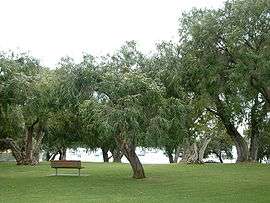 Grove of Peppermint trees overlooking Freshwater Bay on the Swan River | |||||||||||||
 Peppermint Grove | |||||||||||||
| Coordinates | 31°59′56″S 115°46′05″E / 31.999°S 115.768°ECoordinates: 31°59′56″S 115°46′05″E / 31.999°S 115.768°E | ||||||||||||
| Population | 1,529 (2011 census)[1] | ||||||||||||
| • Density | 1,390/km2 (3,600/sq mi) | ||||||||||||
| Established | 1830s | ||||||||||||
| Postcode(s) | 6011 | ||||||||||||
| Area | 1.1 km2 (0.4 sq mi) | ||||||||||||
| Location | 12 km (7 mi) SW of Perth CBD | ||||||||||||
| LGA(s) | Shire of Peppermint Grove | ||||||||||||
| State electorate(s) | Cottesloe | ||||||||||||
| Federal Division(s) | Curtin | ||||||||||||
| |||||||||||||
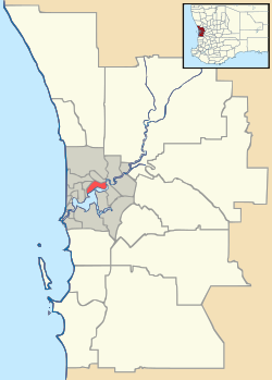
Peppermint Grove is an affluent western suburb of Perth, Western Australia on the north bank of the Swan River at Freshwater Bay. It has been rated as Australia's most expensive suburb, except for exclusive NSW suburbs.[2][3][4] Its local government area, the smallest in the country, is the Shire of Peppermint Grove. The suburb was named after its trademark "Peppermint trees" (Agonis flexuosa) lining many streets. The suburb has long been associated with Western Australia's wealthiest and oldest families: see Robert Pascoe's "Peppermint Grove: Western Australia's Capital Suburb". Their prosperity is reflected in historic houses in the area, such as 'St Just' and The Cliffe. Peppermint Grove remains, to this day, the suburb with the highest average weekly income in Western Australia.[5] Its Sydney and Melbourne equivalents, as Pascoe points out, would be Vaucluse and Toorak. Colin Barnett, Premier of Western Australia, has dubbed the suburb "Australia's Monaco" due to its small size and concentration of wealth.
History
At the time of European settlement and for some years after, the area was thickly wooded with tuart, jarrah, red gum, banksia as well as the peppermint trees which gave the suburb its name.
In 1830, John Butler, an innkeeper, was given a grant of 250 acres (1 km²) on Freshwater Bay, after unsuccessfully attempting to secure land at Claremont. From this location, he operated "The Bush Inn", a stone house he had built and rigged out with native mahogany, commonly known as jarrah. After a series of arguments with the colonial authorities of the day, Butler left for Sydney in October 1835, but did not dispose of the property.
After the death of Butler's wife, Ann, in 1886, a syndicate of businessmen, including Alexander Forrest and George Leake, persuaded Butler's children to sell the land.[6] In 1891, it was subdivided and lots were sold for £7 to £12 each. Two of the earliest residents were Edward Keane, Lord Mayor of Perth, and John Forrest, Premier of Western Australia. Just four years later, residents got a road board, later to become the Peppermint Grove Shire Council - to this day, the smallest in Australia at just 1.1 km².
Geography
Peppermint Grove is situated between Stirling Highway on the west and the Swan River at Freshwater Bay to the east. It spans six blocks, with its main streets named after the first post-subdivision residents of the suburb - McNeil, Forrest, Leake, Irvine, Keane, Johnston and Venn.
At the ABS 2011 census, Peppermint Grove had a high-income, mostly white population of 1,529 people living in 581 dwellings. The ABS noted that 69% of the suburb's workforce were managers or professionals.[7]

Facilities
Cottesloe Primary School and Presbyterian Ladies' College are located within the suburb, as is the council office and the Grove Library on Stirling Highway, a small shopping centre opposite the Cottesloe shopping area, and reserves along the riverfront, most notably Manners Hill Park and Keanes Point Reserve, which offer recreational facilities and jetties.
Churches
There are two churches in Peppermint Grove: St Columba's Presbyterian Church, a Presbyterian church located at the corner of Venn and Keane Streets, and St Mary Star of the Sea, a Roman Catholic church located on Stirling Highway, between McNeil and Forrest streets.[8]
Transport
The western edge of the suburb is serviced by the CircleRoute along Stirling Highway, and the Cottesloe railway station on the Fremantle line.[9] All services are operated by the Public Transport Authority.
Politics
Peppermint Grove is part of the federal division of Curtin. The federal seat is held by the centre right Liberal Party. It is regarded as a safe seat as it has been continually retained by the Liberal Party with the exception of former Liberal member Allan Rocher as an Independent politician between 1996 and 1998. For the parliament of Western Australia, the state electoral district of Cottesloe is also held by the Liberal Party.
Prominent residents and landowners
- Sir Charles Gairdner, Governor of Western Australia and Tasmania
- Members of the Burt family, such as Hon. Sir Francis Burt, former Governor and Chief Justice of Western Australia
- Members of the Lefroy family
- Members of the Lee-Steere family
- Members of the Forrest family, including Alexander Forrest and his brother, Sir John Forrest
- Members of the Bunnings family
- Heath Ledger, Deceased Australian actor
- Bessie Rischbieth
- Hon. David Malcolm, former Lieutenant-Governor and Chief Justice of Western Australia
- David McComb, lead singer of The Triffids
- Richard Goyder, CEO of Wesfarmers
- James Packer, son of Kerry Packer
References
- ↑ Australian Bureau of Statistics (31 October 2012). "State Suburbs: Peppermint Grove". 2011 Census QuickStats. Retrieved 4 July 2012.
- ↑
- ↑ Business Insider, accessed 17 October 2013.
- ↑ Yahoo News, accessed 17 October 2013.
- ↑ Perth has no poor suburbs (WA Today, 23 July 2008)
- ↑ Bolton, Geoffrey; Jenny Gregory (1999). Claremont - A History. Perth: University of WA Press. pp. 1–10. ISBN 1-876268-38-7.
- ↑ Australian Bureau of Statistics (25 October 2007). "Community Profile Series : Peppermint Grove (State Suburb)". 2006 Census of Population and Housing. Retrieved 2007-12-30.
- ↑ Peppermint Grove: Churches
- ↑ Transperth website, accessed 18 November 2006.