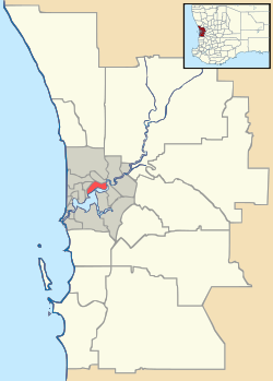
Subiaco, Western Australia
| Subiaco Perth, Western Australia | |||||||||||||
|---|---|---|---|---|---|---|---|---|---|---|---|---|---|
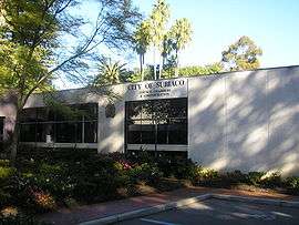 City of Subiaco council chambers | |||||||||||||
 Subiaco | |||||||||||||
| Coordinates | 31°56′56″S 115°49′37″E / 31.949°S 115.827°ECoordinates: 31°56′56″S 115°49′37″E / 31.949°S 115.827°E | ||||||||||||
| Population | 8,015 (2011 census)[1] | ||||||||||||
| • Density | 2,500/km2 (6,490/sq mi) | ||||||||||||
| Established | 1851 | ||||||||||||
| Postcode(s) | 6008 | ||||||||||||
| Area | 3.2 km2 (1.2 sq mi) | ||||||||||||
| Location | 4 km (2 mi) W of Perth CBD | ||||||||||||
| LGA(s) | City of Subiaco | ||||||||||||
| State electorate(s) | Nedlands | ||||||||||||
| Federal Division(s) | Curtin | ||||||||||||
| |||||||||||||
Subiaco (known colloquially as Subi) is an inner western suburb of Perth, Western Australia, north-west of Kings Park. Its local government area is the City of Subiaco.
History
Prior to European settlement the area was home to the Noongar Indigenous people.[2]
The area was settled in 1851 by Italian Benedictine monks. The monks named the area after Subiaco in Italy, the location where Benedict of Nursia, the founder of the Order of Saint Benedict, had begun his work.[2][3]
Landmarks
Landmarks of the suburb include Domain Stadium (aka Subiaco Oval), Mueller Park, the Regal Theatre, the Subiaco Hotel, the Victorian terraces on Catherine Street and the Subiaco Arts Centre.
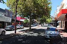
The main street of Subiaco is Rokeby Road, which was named after General Henry Montagu, 6th Baron Rokeby, who was commander of the 1st Infantry Division during the Crimean War. Another important commercial road is Hay Street.
Residential areas include Subi Centro, a modern housing development with the sunken Subiaco railway station on reclaimed industrial land near Wembley, and older heritage properties towards Shenton Park.
Major hospital facilities include St John of God Hospital, Princess Margaret Hospital for Children and King Edward Memorial Hospital for Women.
School facilities include Subiaco Primary School and Perth Modern School, the only academically selective school in Western Australia.
On the corner of Rokeby and Hamersley Roads is a clock tower war memorial, built in 1923 to commemorate soldiers from the district who died in World War I. The names of those who died in later conflicts have also been added.[4]
References
- ↑ Australian Bureau of Statistics (31 October 2012). "State Suburbs: Subiaco". 2011 Census QuickStats. Retrieved 4 July 2012.
- 1 2 "Subiaco History". City of Subiaco. Retrieved 2009-09-02.
- ↑ "History of metropolitan suburb names - S". Landgate. Archived from the original on 14 July 2009. Retrieved 2009-09-02.
- ↑ Stephens, John; Seal, Graham (2015). Remembering the Wars: Commemoration in Western Australian Communities. Black Swan Press. pp. 38–39. ISBN 9780987567079.
Further reading
- Spillman, Ken (1985) Identity Prized: A History of Subiaco Nedlands, University of Western Australia Press. ISBN 0 85564 239 4.
External links
-
 Media related to Subiaco, Western Australia at Wikimedia Commons
 - City of Subiaco