Perche Township, Boone County, Missouri
| Perche Township | |
|---|---|
| Township | |
| Coordinates: 39°05′30″N 92°25′28″W / 39.09171°N 92.42437°WCoordinates: 39°05′30″N 92°25′28″W / 39.09171°N 92.42437°W[1] | |
| Country | United States |
| State | Missouri |
| County | Boone |
| Area | |
| • Total | 83.2 sq mi (215 km2) |
| • Land | 83.0 sq mi (215 km2) |
| • Water | 0.2 sq mi (0.5 km2) |
| Population (2012) | |
| • Total | 4,037 |
| • Density | 49/sq mi (19/km2) |
| Area code(s) | 573 |
| GNIS Feature ID | 766334 |
Perche Township is one of ten townships in Boone County, Missouri, USA. As of the 2012, its population was 4,037.[2] The village of Harrisburg is the only incorporated settlement inside the township.
History
Perche Township was established in 1821.[3]
Settled mainly by settlers from the upland south (Kentucky, Virginia, and Tennessee), the township was named after the Roche Perche Creek, the largest stream in Boone County (save the Missouri) and flows from North to South through the middle of the township. The town of Perche, Missouri was located where the original path of the Boone's Lick Trail crossed Roche Perche Creek. The town site has long been obliterated. The Church and Cemetery of Red Rock are located near here.
Historical locations
The Geographic Names Information System (GNIS) has the following entries associated with the town of Perche:
- Perche (historical) 39°07′30″N 92°24′21″W / 39.12504°N 92.40574°W[4]
- Perche Church 39°11′58″N 92°25′23″W / 39.19948°N 92.42296°W[5]
- Perche Post Office (historical) 39°07′30″N 92°24′21″W / 39.12504°N 92.40574°W[6]
Geography
Perche Township covers an area of 83.2 square miles (215 km2) and is located in the northwest of Boone County. The township contains one incorporated settlement: Harrisburg. The unincorperated settlement of Dripping Springs is also located here. At least two major cemeteries are located within the township: Dripping Springs and Botner. The Roche Perche is the main stream along with the Silver Fork and Lick Fork. Lick Creek Conservation Area is located near the center of the township.
References
- ↑ "Township of Perche". Geographic Names Information System. United States Geological Survey. Retrieved 2014-01-25.
- ↑ "Perche township, Boone County, Missouri". U.S. Census Bureau, American FactFinder 2. Retrieved August 24, 2013.
- ↑ "Boone County Place Names, 1928–1945 (archived)". The State Historical Society of Missouri. Retrieved 4 September 2016.
- ↑ "Perche (historical)". Geographic Names Information System. United States Geological Survey. Retrieved 2014-01-25.
- ↑ "Perche Church". Geographic Names Information System. United States Geological Survey. Retrieved 2014-01-25.
- ↑ "Perche Post Office (historical)". Geographic Names Information System. United States Geological Survey. Retrieved 2014-01-25.
External links
Municipalities and communities of Boone County, Missouri, United States | ||
|---|---|---|
| Cities | 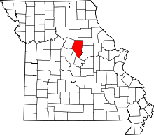 | |
| Villages | ||
| Townships | ||
| Unincorporated communities | ||
| Ghost towns | ||
| Footnotes | ‡This populated place also has portions in an adjacent county or counties | |