Perry Township, Franklin County, Ohio
| Perry Township, Franklin County, Ohio | |
|---|---|
| Township | |
|
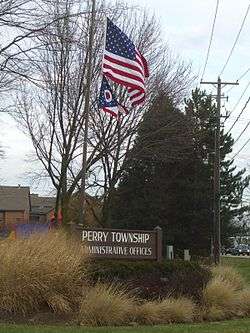
Township administrative offices | |
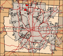 Location of Perry Township in Franklin County. | |
| Coordinates: 40°5′30″N 83°4′14″W / 40.09167°N 83.07056°WCoordinates: 40°5′30″N 83°4′14″W / 40.09167°N 83.07056°W | |
| Country | United States |
| State | Ohio |
| County | Franklin |
| Area[1] | |
| • Total | 2.2 sq mi (6 km2) |
| • Land | 2.2 sq mi (6 km2) |
| • Water | 0 sq mi (0 km2) |
| Elevation[2] | 896 ft (273 m) |
| Population (2010) | |
| • Total | 3,637 |
| • Density | 1,700/sq mi (640/km2) |
| Time zone | Eastern (EST) (UTC-5) |
| • Summer (DST) | EDT (UTC-4) |
| FIPS code | 39-61840[3] |
| GNIS feature ID | 1086110[2] |
Perry Township is one of the seventeen townships of Franklin County, Ohio, United States. The 2010 census found 3,637 people in the township, down from 4,087 in 2000.[4]
Geography
Most of Perry Township is now part of one of these four cities:
- Columbus, the county seat of Franklin County, in the center
- Dublin, in the northwest
- Upper Arlington, in the southwest
- Worthington, in the east
Today, the township is composed of many small "islands," all of which are surrounded by the city of Columbus, except for three: the farthest south "island", which borders Upper Arlington to the south; the largest "island" in the center of the original township, which borders Worthington to the east; and the most northerly "island", which borders three other townships:
- Liberty Township, Delaware County - north
- Orange Township, Delaware County - northeast corner
- Sharon Township - east
Name and history
It is one of twenty-six Perry Townships statewide.[5]
Perry Township was established in 1820.[6]
Government
The township is governed by a three-member board of trustees, who are elected in November of odd-numbered years to a four-year term beginning on the following January 1. Two are elected in the year after the presidential election and one is elected in the year before it. There is also an elected township fiscal officer,[7] who serves a four-year term beginning on April 1 of the year after the election, which is held in November of the year before the presidential election. Vacancies in the fiscal officership or on the board of trustees are filled by the remaining trustees.
The trustees appoint a Township Administrator who administers the day-to-day activities of the township government.
References
- ↑ "2010 Census U.S. Gazetteer Files for County Subdivisions". U.S. Census Bureau, Geography Division. 2 February 2011. Retrieved 18 February 2012.
- 1 2 "US Board on Geographic Names". United States Geological Survey. 2007-10-25. Retrieved 2008-01-31.
- ↑ "American FactFinder". United States Census Bureau. Retrieved 2008-01-31.
- ↑ "Population and Household Counts for Governmental Units: 2010, 2000, 1990" (PDF). Ohio Department of Development. August 2011. Retrieved 18 February 2012.
- ↑ "Detailed map of Ohio" (PDF). United States Census Bureau. 2000. Retrieved 2007-02-16.
- ↑ Kilbourn, John (1833). "The Ohio Gazetteer, or, a Topographical Dictionary". Scott and Wright. p. 365. Retrieved 12 December 2013.
- ↑ §503.24, §505.01, and §507.01 of the Ohio Revised Code. Accessed 4/30/2009.
External links
Municipalities and communities of Franklin County, Ohio, United States | ||
|---|---|---|
| Cities |  | |
| Villages | ||
| Townships | ||
| CDPs | ||
| Unincorporated communities | ||
| Footnotes | ‡This populated place also has portions in an adjacent county or counties | |