Pierce Township, DeKalb County, Illinois
| Pierce Township | |
|---|---|
| Township | |
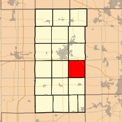 Location in DeKalb County | |
 DeKalb County's location in Illinois | |
| Coordinates: 41°50′54″N 88°39′29″W / 41.84833°N 88.65806°WCoordinates: 41°50′54″N 88°39′29″W / 41.84833°N 88.65806°W | |
| Country |
|
| State |
|
| County | DeKalb |
| Established | Prior to 1853 |
| Area | |
| • Total | 35.11 sq mi (90.9 km2) |
| • Land | 35.03 sq mi (90.7 km2) |
| • Water | 0.09 sq mi (0.2 km2) 0.26% |
| Elevation | 804 ft (245 m) |
| Population (2010) | |
| • Total | 454 |
| • Density | 13/sq mi (5/km2) |
| Time zone | CST (UTC-6) |
| • Summer (DST) | CDT (UTC-5) |
| ZIP codes | 60115, 60119, 60151, 60520 |
| GNIS feature ID | 0429561 |
Pierce Township is one of nineteen townships in DeKalb County, Illinois, USA. As of the 2010 census, its population was 454 and it contained 187 housing units.[1] Pierce Township was formed from Squaw Grove and Pampas Township before 1853.
Geography
According to the 2010 census, the township has a total area of 35.11 square miles (90.9 km2), of which 35.03 square miles (90.7 km2) (or 99.77%) is land and 0.09 square miles (0.23 km2) (or 0.26%) is water.[1]
Cities, towns, villages
- Maple Park (partial)
Cemeteries
The township contains these two cemeteries: Community Methodist and Saint Marys.
School districts
- Dekalb Community Unit School District 428
- Hinckley-Big Rock Community Unit School District 429
- Indian Creek Community Unit District 425
- Kaneland Community Unit School District 302
Political districts
- Illinois's 14th congressional district
- State House District 70
- State Senate District 35
References
- "Pierce Township, DeKalb County, Illinois". Geographic Names Information System. United States Geological Survey. Retrieved 2010-07-04.
- United States Census Bureau 2009 TIGER/Line Shapefiles
- United States National Atlas
- 1 2 "Population, Housing Units, Area, and Density: 2010 - County -- County Subdivision and Place -- 2010 Census Summary File 1". United States Census. Retrieved 2013-05-28.
External links
 |
DeKalb Township | Cortland Township | Virgil Township, Kane County | |
| Afton Township | |
Kaneville Township, Kane County | ||
| ||||
| | ||||
| Clinton Township | Squaw Grove Township | Big Rock Township, Kane County |
Municipalities and communities of DeKalb County, Illinois, United States | ||
|---|---|---|
| Cities | ||
| Town | ||
| Villages | ||
| Townships | ||
| Unincorporated communities | ||
| Ghost towns | ||
| Footnotes | ‡This populated place also has portions in an adjacent county or counties | |
This article is issued from Wikipedia - version of the 12/3/2013. The text is available under the Creative Commons Attribution/Share Alike but additional terms may apply for the media files.