Pierre Part, Louisiana
| Pierre Part, Louisiana | |
| Census-designated place | |
| Country | United States |
|---|---|
| State | Louisiana |
| Parish | Assumption |
| Elevation | 3 ft (0.9 m) |
| Coordinates | 29°57′40″N 91°12′24″W / 29.96111°N 91.20667°WCoordinates: 29°57′40″N 91°12′24″W / 29.96111°N 91.20667°W |
| Area | 7.98 km2 (3.08 sq mi) |
| - land | 7.95 km2 (3.07 sq mi) |
| - water | 0.03 km2 (0.01 sq mi), 0.38% |
| Population | 3,169 (2010) |
| Density | 398.4/km2 (1,031.9/sq mi) |
| Timezone | CST (UTC-6) |
| - summer (DST) | CDT (UTC-5) |
| Area code | 985 |
|
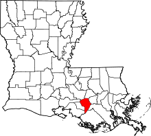
Location of Pierre Part in Louisiana | |
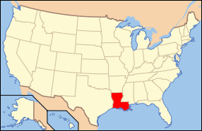
 Location of Louisiana in the United States | |
Pierre Part (French: Ville de Pierre Part) is a census-designated place (CDP) in Assumption Parish, Louisiana, United States. The population was 3,169 at the 2010 census.[1]
History

Pierre Part was founded by Acadian French settlers after the Great Upheaval of 1755, during which much of the French population of Acadia was expelled by its British conquerors. The town remained isolated from most of the world, since it is surrounded by water and was inaccessible by land until the mid-twentieth century. Before the Great Depression, the inhabitants of Pierre Part were fishermen; after the Depression, many men of the town were forced to find work in other fields including logging, levee building, and the growing petroleum industry in Louisiana. Fewer people continue the traditional ways of fishing and living off the land with each generation.
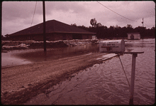
Pierre Part experienced flooding when the Morganza Spillway was opened during the 1973 Mississippi River flooding.
The people of Pierre Part are predominantly of French ancestry, of families who either came directly from France or those whose came from Canada (Acadia), and before that, France. Until the early- to mid-twentieth century the people almost exclusively spoke Cajun French at home. This caused the people of Pierre Part and the rest of the Cajun community to be labeled as "backwards" or "ignorant" by outsiders, and in many cases from the 1910s to the 1970s, students whose first language was French were punished corporally in school for speaking it. From the 1970s onward, extremely few children were taught Cajun French as a first language, since the previous generations were taught to be ashamed of their heritage. In the 1990s an effort was made to reintroduce French into the school systems. This became somewhat controversial as the French taught in school was not Cajun French. Many of the teachers brought in were Belgian, French, and Canadian who taught their own dialect of French. However, there are still many who contend that the "Standard French" taught in French Immersion classes at Pierre Part Elementary School is the best chance that local Cajuns have at preserving their language and culture, since there is no written standard for teaching the Cajun dialect of the French language.
The History Channel's reality show, Swamp People, features the Landry family, a Cajun family who lives in Pierre Part; the series debuted on History in 2010.
Geography
Pierre Part is located at 29°57′40″N 91°12′24″W / 29.96111°N 91.20667°W (29.960975, -91.206612).[2] According to the United States Census Bureau, the CDP has a total area of 3.08 square miles (7.98 km2), of which 3.07 square miles (7.95 km2) is land and 0.012 square miles (0.03 km2), or 0.37%, is water.[1]
Demographics
It is the principal city of the Pierre Part Micropolitan Statistical Area, which includes all of Assumption Parish. It is also part of the larger Baton Rouge–Pierre Part Combined Statistical Area.
As of the census[3] of 2000, there were 3,239 people, 1,236 households, and 928 families residing in the CDP. The population density was 1,072.4 people per square mile (414.1/km²). There were 1,355 housing units at an average density of 448.6 per square mile (173.2/km²). The racial makeup of the CDP was 99.23% White, 0.09% African American, 0.22% Native American, and 0.46% from two or more races. Hispanic or Latino of any race were 0.62% of the population. In 2005, 60.7% of the population over the age of five spoke English at home, and 38.8% of the population spoke French.[4]
There were 1,236 households out of which 39.4% had children under the age of 18 living with them, 62.0% were married couples living together, 9.7% had a female householder with no husband present, and 24.9% were non-families. 22.1% of all households were made up of individuals and 9.8% had someone living alone who was 65 years of age or older. The average household size was 2.62 and the average family size was 3.06.
In the CDP the population was spread out with 27.3% under the age of 18, 9.4% from 18 to 24, 29.9% from 25 to 44, 22.2% from 45 to 64, and 11.2% who were 65 years of age or older. The median age was 35 years. For every 100 females there were 94.5 males. For every 100 females age 18 and over, there were 91.9 males.
The median income for a household in the CDP was $37,431, and the median income for a family was $43,393. Males had a median income of $39,185 versus $18,418 for females. The per capita income for the CDP was $14,939. About 13.4% of families and 13.6% of the population were below the poverty line, including 17.3% of those under age 18 and 17.3% of those age 65 or over.
Education
Transportation
Louisiana Highway 70 runs through Pierre Part.
References
- 1 2 "Geographic Identifiers: 2010 Demographic Profile Data (G001): Pierre Part CDP, Louisiana". U.S. Census Bureau, American Factfinder. Retrieved May 16, 2013.
- ↑ "US Gazetteer files: 2010, 2000, and 1990". United States Census Bureau. 2011-02-12. Retrieved 2011-04-23.
- ↑ "American FactFinder". United States Census Bureau. Retrieved 2008-01-31.
- ↑ http://www.mla.org/cgi-shl/docstudio/docs.pl?map_data_results
