Pila-Canale
| Pila-Canale | |
|---|---|
|
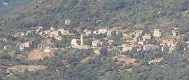
A general view of Pila-Canale | |
 Pila-Canale | |
|
Location within Corsica region  Pila-Canale | |
| Coordinates: 41°48′49″N 8°54′37″E / 41.8136°N 8.9103°ECoordinates: 41°48′49″N 8°54′37″E / 41.8136°N 8.9103°E | |
| Country | France |
| Region | Corsica |
| Department | Corse-du-Sud |
| Arrondissement | Ajaccio |
| Canton | Santa-Maria-Siché |
| Government | |
| • Mayor (2008–2014) | Antoine de Peretti |
| Area1 | 18.8 km2 (7.3 sq mi) |
| Population (2008)2 | 283 |
| • Density | 15/km2 (39/sq mi) |
| Time zone | CET (UTC+1) |
| • Summer (DST) | CEST (UTC+2) |
| INSEE/Postal code | 2A232 / 20123 |
| Elevation |
13–561 m (43–1,841 ft) (avg. 350 m or 1,150 ft) |
|
1 French Land Register data, which excludes lakes, ponds, glaciers > 1 km² (0.386 sq mi or 247 acres) and river estuaries. 2 Population without double counting: residents of multiple communes (e.g., students and military personnel) only counted once. | |
Pila-Canale is a commune in the Corse-du-Sud department of France on the island of Corsica.
First section straight then first bend to the right.
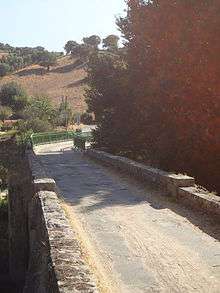
Calzola bridge
The Calzola bridge, at the border with Casalabriva, has two bends seemingly due to a misalignment of the two extremities of the bridge.
Population
| Historical population | ||
|---|---|---|
| Year | Pop. | ±% |
| 1962 | 461 | — |
| 1968 | 488 | +5.9% |
| 1975 | 408 | −16.4% |
| 1982 | 305 | −25.2% |
| 1990 | 265 | −13.1% |
| 1999 | 278 | +4.9% |
| 2008 | 283 | +1.8% |
See also
References
| Wikimedia Commons has media related to Pila-Canale. |
This article is issued from Wikipedia - version of the 1/28/2015. The text is available under the Creative Commons Attribution/Share Alike but additional terms may apply for the media files.