Zoza
| Zoza | |
|---|---|
|
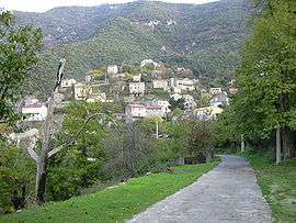
A general view of the village of Zoza | |
 Zoza | |
|
Location within Corsica region  Zoza | |
| Coordinates: 41°43′07″N 9°04′14″E / 41.7186°N 9.0706°ECoordinates: 41°43′07″N 9°04′14″E / 41.7186°N 9.0706°E | |
| Country | France |
| Region | Corsica |
| Department | Corse-du-Sud |
| Arrondissement | Sartène |
| Canton | Tallano-Scopamène |
| Intercommunality | l'Alta Rocca |
| Government | |
| • Mayor (2008–2014) | Pierre Marcellesi |
| Area1 | 5.05 km2 (1.95 sq mi) |
| Population (2008)2 | 60 |
| • Density | 12/km2 (31/sq mi) |
| Time zone | CET (UTC+1) |
| • Summer (DST) | CEST (UTC+2) |
| INSEE/Postal code | 2A363 / 20112 |
| Elevation |
158–826 m (518–2,710 ft) (avg. 450 m or 1,480 ft) |
|
1 French Land Register data, which excludes lakes, ponds, glaciers > 1 km² (0.386 sq mi or 247 acres) and river estuaries. 2 Population without double counting: residents of multiple communes (e.g., students and military personnel) only counted once. | |
Zoza is a commune in the Corse-du-Sud department of France on the island of Corsica.
Geography
The Rizzanese River runs through the village which is located 88 km from Ajaccio.
Demographics
| Historical population | ||
|---|---|---|
| Year | Pop. | ±% |
| 1962 | 51 | — |
| 1968 | 84 | +64.7% |
| 1975 | 80 | −4.8% |
| 1982 | 67 | −16.2% |
| 1990 | 55 | −17.9% |
| 1999 | 51 | −7.3% |
| 2008 | 60 | +17.6% |
See also
References
| Wikimedia Commons has media related to Zoza. |
This article is issued from Wikipedia - version of the 7/21/2016. The text is available under the Creative Commons Attribution/Share Alike but additional terms may apply for the media files.