Pine Point, Northwest Territories
Pine Point was a townsite on the south shore of Great Slave Lake in the Northwest Territories of Canada that lay between the towns of Hay River and Fort Resolution. It was built to serve the work force at the Pine Point Mine, an open-pit mine that produced lead and zinc ores. The town reached a peak population of about 2,000 in 1976, but was abandoned and deconstructed soon after the mine closed in 1988.

| Pine Point | |
|---|---|
| Country | Canada |
| Province | Northwest Territories |
| Established | 1963 |
| Extinct | Early 1990s |
| Government | |
| • Type | Mayor-council government |
| • Mayor | Michael Lenton (1988) |
| Population (2016) | |
| • Total | 0 |
History
The first buildings were erected in 1952 during the original exploration and development campaign, and even before that a number of log cabins had been built in the late 1920s. The modern town was surveyed in 1962 and became operational by 1963.
The town was a joint-venture between the Canadian Government and the mine owner, Cominco. It became a territorial settlement in the 1970s with private businesses. As an unincorporated place, it recorded a population of 1,225 in the 1971 census.[1] Pine Point had an elementary school (kindergarten to grade 5)—Galena Heights—and a grade 6 to 12 school, called Matonabbee School. The last graduating class was in 1988 as the mine was closing. Mike Lenton was the town's last mayor.[2]
More than 15 million tonnes grading over 7% zinc plus lead (about 5 years of normal production) was depleted from the 1985 and 1986 ore reserves.
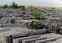
The mine was closed in 1988, forcing the single-industry town to close. Pine Point houses were sold cheaply, and many of the buildings were then moved to Fort Resolution (including the hockey arena), Hay River and northern Alberta. The remaining buildings were demolished, and today the site is completely abandoned, although there is still evidence of the street layout.[3]
Pine Point is the subject of a 2011 web documentary Welcome to Pine Point, created by Michael Simons and Paul Shoebridge and produced by the National Film Board of Canada. The web documentary includes audiovisual material and mementos compiled by ex-Pine Point resident Richard Cloutier for his own website, Pine Point Revisited.[4][5]
Demographics
| Historical population | ||
|---|---|---|
| Year | Pop. | ±% |
| 1966 | 675 | — |
| 1971 | 1,225 | +81.5% |
| 1976 | 1,975 | +61.2% |
| 1981 | 1,850 | −6.3% |
| 1986 | 1,600 | −13.5% |
| 1991 | 9 | −99.4% |
| 1996 | 0 | −100.0% |
Pine Point was first settled in 1952, but did not become an established settlement until 1963. As the mine expanded during the 1970s, so did the population, reaching a peak of nearly 2,000 by the 1976 census.[6]
Education
- Galena Heights Elementary School
Matonabbee School Information Closed 1988 Grades 9-12 Colour(s) Purple & yellow Team name Polar bears (grades K-5)
- Matonabbee School (grades 6-12)
The Matonabbee School burned down sometime during the 1980s, after which it was relocated.
Places of worship
- Anglican Church, the name of which is not known[7]
- Catholic Church, the name of which is not known[7]
- Pine Point Pentecostal Church[8]
- Pines Point Church of the Nazarene
Transportation
Pine Point was served by Northwest Territories Highway 5, and by the Mackenzie Northern Railway which was owned by the Canadian National Railway. Ore concentrates from the mine were moved south by the railroad. The town also had a small airport.
Notable people
- Geoff Sanderson, professional ice hockey player
In popular culture
The song "Pine Point" by the Canadian punk rock band PUP is named after the town.
Further reading
- Andersen Management Services Inc. (1987). Socio-economic impact assessment for the town of Pine Point, NWT. [s.l.]: Andersen Management Services.
- Deprez, P. (1973). The Pine Point Mine and the development of the area south of Great Slave Lake. Winnipeg: Center for Settlement Studies, University of Manitoba.
- Pine Point Mines Limited. (1978). Zinc/lead mining at Pine Point, N.W.T. Pine Point, N.W.T.: The Mines.
- Wilson, J., & Petruk, W. (1985). Quantitative mineralogy of Pine Point tailings. [Ottawa?]: CANMET, Energy, Mines and Resources Canada.
- Gibbins, W. (1988) Metallic mineral potential of the Western Interior Platform of the Northwest Territories. Geoscience Canada. Vol 15 NO. 2 pp 117–119
References
- ↑ 1976 Census of Canada Supplementary Bulletin, Populations: Geographic and Demographic, Population of Unincorporated Places—Canada, Bulletin 8SG.1. Statistics Canada. May 1978. p. 86.
- ↑ "People_of_Pine_Point3". pinepointrevisited.homestead.com. Retrieved 2016-01-19.
- ↑ Keeling, Arn; Sandlos, John (2012). "Claiming the New North: Development and Colonialism at the Pine Point Mine, Northwest Territories, Canada" (PDF). Faculty of Arts. Memorial University of Newfoundland: 18. ISSN 1752-7023. Lay summary – Memorial University Research Repository.
- ↑ Quenneville, Guy (31 January 2011). "Remembering a lost mining town". Northern News Services. Retrieved 1 February 2011.
- ↑ MacKie, John (14 April 2011). "Lost northern town is back, on the Net". Vancouver Sun. Retrieved 14 April 2011.
- ↑ Bone, Robert M. (September 1988). "Resource Towns in the Mackenzie Basin" (PDF). Cahiers de Géographie du Québec. University of Saskatchewan: Érudit. 42: 249–259. doi:10.7202/022739ar. Retrieved 18 January 2016.
- 1 2 "Photos_of_Pine4". pinepointrevisited.homestead.com. Retrieved 2016-01-19.
- ↑ "People_of_Pine_Point8". pinepointrevisited.homestead.com. Retrieved 2016-01-19.
External links
- Pine Point Revisited
- 1926 Ted Nagle and the Pine Point Discovery NWT Historical Timeline, Prince of Wales Northern Heritage Centre
- NFB - Welcome to Pine Point produced by the National Film Board, created by The Goggles: Paul Shoebridge and Michael Simons
| Census divisions | |||||||||||
|---|---|---|---|---|---|---|---|---|---|---|---|
| Former census divisions | |||||||||||
| Dehcho Region |
| ||||||||||
| Inuvik Region |
| ||||||||||
| North Slave Region |
| ||||||||||
| Sahtu Region |
| ||||||||||
| South Slave Region |
| ||||||||||
| Weather stations (outside of communities) | |||||||||||
| Mine sites |
| ||||||||||
| DEW line and NWS sites |
| ||||||||||
| Hudson's Bay Company trading posts | |||||||||||
| Former districts |
| ||||||||||
| |||||||||||
Coordinates: 60°50′N 114°28′W / 60.833°N 114.467°W